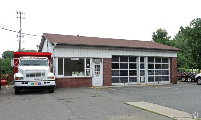
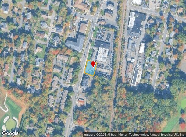
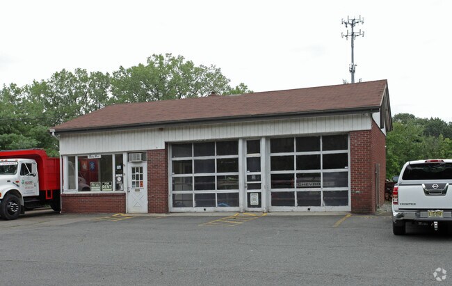
Property Record
39 Kinderkamack Rd, Emerson, NJ 07630
NEARBY LISTINGS FOR SALE OR LEASE
Property Detail
39 Kinderkamack Rd
New York-Jersey City-White Plains, NY-NJ
125X100 5LT
14-00610-0000-00008
Bergen
Commercialnec
New Jersey
X
8
34003C0182H
0.29 AC
2024
North Central Bergen
2025
Northern New Jersey
014000
DEMOGRAPHICS near 39 Kinderkamack Rd
1 Mile
3 Mile
5 Mile
2024 Total Population
9,822
106,871
305,915
2029 Population
9,781
106,570
305,269
Pop Growth 2024-2029
(0.42%)
(0.28%)
(0.21%)
Average Age
43
43
42
2024 Total Households
3,429
36,647
104,546
HH Growth 2024-2029
(0.47%)
(0.38%)
(0.24%)
Median Household Inc
$131,930
$136,830
$134,571
Avg Household Size
2.80
2.80
2.80
2024 Avg HH Vehicles
2.00
2.00
2.00
Median Home Value
$658,858
$621,293
$646,751
Median Year Built
1958
1956
1957
Nearby Places
Map Layers
Map Styles
 Street
 Aerial
- Restaurants
- Banks
- Shops
- Fitness
- Groceries
PUBLIC TRANSPORTATION
COMMUTER RAIL
Emerson (Pascack Valley Line - NJ Transit Commuter Rail (NJ Transit))
DRIVE
WALK
Distance
Emerson (Pascack Valley Line - NJ Transit Commuter Rail (NJ Transit))
0 min
5 min
0.3 mi
Oradell (Pascack Valley Line - NJ Transit Commuter Rail (NJ Transit))
DRIVE
WALK
Distance
Oradell (Pascack Valley Line - NJ Transit Commuter Rail (NJ Transit))
2 min
1.3 mi
AIRPORT
LaGuardia
DRIVE
WALK
Distance
LaGuardia
35 min
21.8 mi
Newark Liberty International
DRIVE
WALK
Distance
Newark Liberty International
31 min
24.4 mi
Westchester County
DRIVE
WALK
Distance
Westchester County
46 min
30.4 mi
Freight Ports
NY - Red Hook Container Terminal
DRIVE
WALK
Distance
NY - Red Hook Container Terminal
44 min
25.6 mi
Nearby Properties
Address
Land Use
TOTAL SIZE
Lot Size
Zoning
Address
Land Use
TOTAL SIZE
Lot Size
Zoning
1,267 SF
0.14 AC
BML
Address
Land Use
TOTAL SIZE
Lot Size
Zoning
45,191 SF
3.11 AC
BL
Address
Land Use
TOTAL SIZE
Lot Size
Zoning
62.88 AC
R100
Address
Land Use
TOTAL SIZE
Lot Size
Zoning
19.96 AC
HSO
Address
Land Use
TOTAL SIZE
Lot Size
Zoning
394,039 SF
24.31 AC
BG
Address
Land Use
TOTAL SIZE
Lot Size
Zoning
164,588 SF
14.60 AC
BG
Address
Land Use
TOTAL SIZE
Lot Size
Zoning
8.78 AC
HSO
Address
Land Use
TOTAL SIZE
Lot Size
Zoning
59 AC
AA
Address
Land Use
TOTAL SIZE
Lot Size
Zoning
185,878 SF
33.44 AC
B
Address
Land Use
TOTAL SIZE
Lot Size
Zoning
23,572 SF
98.75 AC
CR
Address
Land Use
TOTAL SIZE
Lot Size
Zoning
296,562 SF
20.49 AC
BIL
Address
Land Use
TOTAL SIZE
Lot Size
Zoning
205,856 SF
12.49 AC
BIL
Address
Land Use
TOTAL SIZE
Lot Size
Zoning
205,856 SF
12.12 AC
BIL
Address
Land Use
TOTAL SIZE
Lot Size
Zoning
9.20 AC
OR
Address
Land Use
TOTAL SIZE
Lot Size
Zoning
21.48 AC
Address
Land Use
TOTAL SIZE
Lot Size
Zoning
156,877 SF
12.60 AC
BG
Address
Land Use
TOTAL SIZE
Lot Size
Zoning
29,018 SF
4.40 AC
BG
Address
Land Use
TOTAL SIZE
Lot Size
Zoning
47,623 SF
88.60 AC
B
Address
Land Use
TOTAL SIZE
Lot Size
Zoning
45,269 SF
5.66 AC
BG
Address
Land Use
TOTAL SIZE
Lot Size
Zoning
161,352 SF
14.02 AC
BG
Address
Land Use
TOTAL SIZE
Lot Size
Zoning
192,486 SF
11.82 AC
BL
Address
Land Use
TOTAL SIZE
Lot Size
Zoning
82.73 AC
Address
Land Use
TOTAL SIZE
Lot Size
Zoning
92,778 SF
8.86 AC
BIL
Address
Land Use
TOTAL SIZE
Lot Size
Zoning
4.55 AC
BIL
Address
Land Use
TOTAL SIZE
Lot Size
Zoning
21.74 AC
SC
Address
Land Use
TOTAL SIZE
Lot Size
Zoning
144,868 SF
11.14 AC
BG
Address
Land Use
TOTAL SIZE
Lot Size
Zoning
82,969 SF
9.99 AC
R1
Address
Land Use
TOTAL SIZE
Lot Size
Zoning
Address
Land Use
TOTAL SIZE
Lot Size
Zoning
0.78 AC
B
Address
Land Use
TOTAL SIZE
Lot Size
Zoning
157,100 SF
11.84 AC
BG
The World's #1 Commercial Real Estate Marketplace
Connect with us
© 2026 CoStar Group
The information above has been obtained from sources believed reliable. While we do not doubt its accuracy we have not verified it and make no guarantee, warranty or representation about it. It is your responsibility to independently confirm its accuracy and completeness. Any projections, opinions, assumptions, or estimates used are for example only and do not represent the current or future performance of the property. The value of this transaction to you depends on tax and other factors which should be evaluated by your tax, financial, and legal advisors. You and your advisors should conduct a careful, independent investigation of the property to determine to your satisfaction the suitability of the property for your needs.