Property Record
39 Ky Hwy S, Crab Orchard, KY 40419

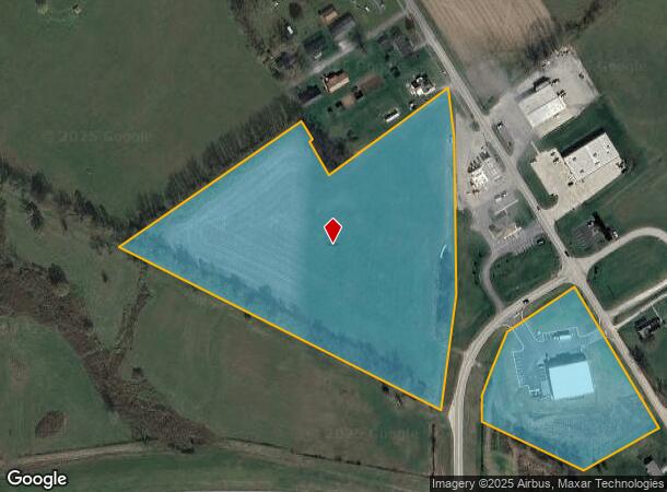

This Property Is For Sale
NEARBY LISTINGS FOR SALE OR LEASE
-
-
View all Crab Orchard listings for sale on LoopNet.com
Property Detail
39 Ky Hwy S
Danville, KY
C N Scot Estate Property
089-04-11-003.00
TR 1 [10.142 ACS]
Farms
Lincoln
X
Kentucky
21137C0184C
10.14 AC
2024
Kentucky East Area
2025
Other Market Areas
920400
DEMOGRAPHICS near 39 Ky Hwy S
1 Mile
3 Mile
5 Mile
2024 Total Population
833
1,963
3,677
2029 Population
841
1,985
3,732
Pop Growth 2024-2029
+ 0.96%
+ 1.12%
+ 1.50%
Average Age
41
41
41
2024 Total Households
333
783
1,455
HH Growth 2024-2029
+ 0.90%
+ 1.02%
+ 1.51%
Median Household Inc
$40,469
$40,660
$41,052
Avg Household Size
2.50
2.50
2.50
2024 Avg HH Vehicles
2.00
2.00
2.00
Median Home Value
$114,474
$114,208
$120,893
Median Year Built
1984
1985
1986
Nearby Places
Map Layers
Map Styles
 Street
 Aerial
- Restaurants
- Banks
- Shops
- Fitness
- Groceries
Nearby Properties
Address
Land Use
TOTAL SIZE
Lot Size
Zoning
Address
Land Use
TOTAL SIZE
Lot Size
Zoning
3.24 AC
#N/A
Address
Land Use
TOTAL SIZE
Lot Size
Zoning
14.50 AC
COMMERCIAL
Address
Land Use
TOTAL SIZE
Lot Size
Zoning
1.49 AC
Address
Land Use
TOTAL SIZE
Lot Size
Zoning
1.45 AC
COMMERCIAL
Address
Land Use
TOTAL SIZE
Lot Size
Zoning
1.67 AC
COM
Address
Land Use
TOTAL SIZE
Lot Size
Zoning
Address
Land Use
TOTAL SIZE
Lot Size
Zoning
156.20 AC
AG
Address
Land Use
TOTAL SIZE
Lot Size
Zoning
401.32 AC
Address
Land Use
TOTAL SIZE
Lot Size
Zoning
27.01 AC
Address
Land Use
TOTAL SIZE
Lot Size
Zoning
149.80 AC
Address
Land Use
TOTAL SIZE
Lot Size
Zoning
1.38 AC
Address
Land Use
TOTAL SIZE
Lot Size
Zoning
9.72 AC
COM
Address
Land Use
TOTAL SIZE
Lot Size
Zoning
2,992 SF
0.31 AC
COM
Address
Land Use
TOTAL SIZE
Lot Size
Zoning
52 SF
56.51 AC
COM
Address
Land Use
TOTAL SIZE
Lot Size
Zoning
1.43 AC
COM
Address
Land Use
TOTAL SIZE
Lot Size
Zoning
273.75 AC
AG
Address
Land Use
TOTAL SIZE
Lot Size
Zoning
50.24 AC
Address
Land Use
TOTAL SIZE
Lot Size
Zoning
2.01 AC
Address
Land Use
TOTAL SIZE
Lot Size
Zoning
Address
Land Use
TOTAL SIZE
Lot Size
Zoning
0.22 AC
COM
Address
Land Use
TOTAL SIZE
Lot Size
Zoning
Address
Land Use
TOTAL SIZE
Lot Size
Zoning
Address
Land Use
TOTAL SIZE
Lot Size
Zoning
9.60 AC
AG
Address
Land Use
TOTAL SIZE
Lot Size
Zoning
1,554 SF
249 AC
Address
Land Use
TOTAL SIZE
Lot Size
Zoning
0.34 AC
COM
Address
Land Use
TOTAL SIZE
Lot Size
Zoning
0.75 AC
Address
Land Use
TOTAL SIZE
Lot Size
Zoning
369.40 AC
Address
Land Use
TOTAL SIZE
Lot Size
Zoning
2,602 SF
27.34 AC
Address
Land Use
TOTAL SIZE
Lot Size
Zoning
2,308 SF
274 AC
AG
Address
Land Use
TOTAL SIZE
Lot Size
Zoning
0.45 AC
RESIDENTIA
The World's #1 Commercial Real Estate Marketplace
Connect with us
© 2025 CoStar Group
The information above has been obtained from sources believed reliable. While we do not doubt its accuracy we have not verified it and make no guarantee, warranty or representation about it. It is your responsibility to independently confirm its accuracy and completeness. Any projections, opinions, assumptions, or estimates used are for example only and do not represent the current or future performance of the property. The value of this transaction to you depends on tax and other factors which should be evaluated by your tax, financial, and legal advisors. You and your advisors should conduct a careful, independent investigation of the property to determine to your satisfaction the suitability of the property for your needs.