Property Record
39 Perkins St, Lowell, MA 01854

Save to a Folder
{{folder.Name}}
{{folder.ListingIds.length}} Properties
{{folder.ListingIds.length}} Property
Create a New Folder
Property Detail
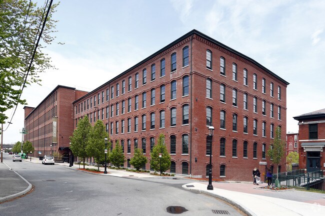
39 Perkins St
LOWE-000136-004605-000039
Middlesex
Publicschool
Massachusetts
INST
39
B and X Area of moderate flood hazard, usually the area between the limits of the 100-year and 500-year floods.
0.80 AC
2024
The Acre
2025
Boston
388300
Boston-Cambridge-Newton, MA-NH
142,490 SF
NEARBY LISTINGS FOR SALE OR LEASE
DEMOGRAPHICS near 39 Perkins St
1 mile
3 mile
5 mile
2025 Total Population
41,990
140,525
206,726
2030 Population
43,275
144,751
213,641
Pop Growth 2025-2030
+ 3.06%
+ 3.01%
+ 3.35%
Average Age
36
39
40
2025 Total Households
15,675
50,827
75,487
HH Growth 2025-2030
+ 3.40%
+ 3.22%
+ 3.53%
Median Household Inc
$60,030
$83,711
$95,796
Avg Household Size
2.30
2.60
2.60
2025 Avg HH Vehicles
1.00
2.00
2.00
Median Home Value
$365,891
$448,869
$497,346
Median Year Built
1948
1956
1965
Nearby Places
Map Layers
Map Styles
 Street
 Aerial
Layers
 Traffic
 Biking
Places
Listings with unknown addresses are not visible on the map
- Restaurants
- Banks
- Shops
- Fitness
- Groceries
PUBLIC TRANSPORTATION
COMMUTER RAIL
Lowell (Lowell Line - Massachusetts Bay Transportation Authority Commuter Rail (Purple Line))
Drive
Walk
Distance
Lowell (Lowell Line - Massachusetts Bay Transportation Authority Commuter Rail (Purple Line))
4 min
1.6 mi
North Billerica (Lowell Line - Massachusetts Bay Transportation Authority Commuter Rail (Purple Line))
Drive
Walk
Distance
North Billerica (Lowell Line - Massachusetts Bay Transportation Authority Commuter Rail (Purple Line))
13 min
5.9 mi
AIRPORT
Manchester Boston Regional
Drive
Walk
Distance
Manchester Boston Regional
46 min
29.4 mi
General Edward Lawrence Logan International
Drive
Walk
Distance
General Edward Lawrence Logan International
48 min
31.6 mi
Freight Ports
Port of Boston
Drive
Walk
Distance
Port of Boston
49 min
31.4 mi
Nearby Properties
Address
Land Use
TOTAL SIZE
Lot Size
Zoning
Address
Land Use
TOTAL SIZE
Lot Size
Zoning
9.73 AC
INST
Address
Land Use
TOTAL SIZE
Lot Size
Zoning
14.73 AC
HRC
Address
Land Use
TOTAL SIZE
Lot Size
Zoning
70.20 AC
R3
Address
Land Use
TOTAL SIZE
Lot Size
Zoning
30,744 SF
31.28 AC
INST
Address
Land Use
TOTAL SIZE
Lot Size
Zoning
275,574 SF
6.66 AC
HRCO
Address
Land Use
TOTAL SIZE
Lot Size
Zoning
224,076 SF
1.15 AC
HCD
Address
Land Use
TOTAL SIZE
Lot Size
Zoning
803 SF
3.29 AC
R1
Address
Land Use
TOTAL SIZE
Lot Size
Zoning
215,884 SF
1.55 AC
DMU
Address
Land Use
TOTAL SIZE
Lot Size
Zoning
134,439 SF
3.29 AC
DMU
Address
Land Use
TOTAL SIZE
Lot Size
Zoning
6.30 AC
UMU
Address
Land Use
TOTAL SIZE
Lot Size
Zoning
11.45 AC
TTF
Address
Land Use
TOTAL SIZE
Lot Size
Zoning
2.15 AC
INST
Address
Land Use
TOTAL SIZE
Lot Size
Zoning
15.16 AC
SMF
Address
Land Use
TOTAL SIZE
Lot Size
Zoning
19.97 AC
SSF
Address
Land Use
TOTAL SIZE
Lot Size
Zoning
59.09 AC
SSF
Address
Land Use
TOTAL SIZE
Lot Size
Zoning
6.27 AC
DMU
Address
Land Use
TOTAL SIZE
Lot Size
Zoning
225,252 SF
2.31 AC
DMU
Address
Land Use
TOTAL SIZE
Lot Size
Zoning
262,607 SF
4.33 AC
INST
Address
Land Use
TOTAL SIZE
Lot Size
Zoning
10.48 AC
INST
Address
Land Use
TOTAL SIZE
Lot Size
Zoning
7.18 AC
SMF
Address
Land Use
TOTAL SIZE
Lot Size
Zoning
168,114 SF
0.17 AC
UMU
Address
Land Use
TOTAL SIZE
Lot Size
Zoning
2.62 AC
INST
Address
Land Use
TOTAL SIZE
Lot Size
Zoning
7.25 AC
INST
Address
Land Use
TOTAL SIZE
Lot Size
Zoning
167,201 SF
6.31 AC
DMU
Address
Land Use
TOTAL SIZE
Lot Size
Zoning
20.88 AC
TSF
Address
Land Use
TOTAL SIZE
Lot Size
Zoning
185,172 SF
2.93 AC
DMU
Address
Land Use
TOTAL SIZE
Lot Size
Zoning
245,562 SF
1.44 AC
DMU
Address
Land Use
TOTAL SIZE
Lot Size
Zoning
13.74 AC
SSF
Address
Land Use
TOTAL SIZE
Lot Size
Zoning
63,768 SF
8.83 AC
SMU
Address
Land Use
TOTAL SIZE
Lot Size
Zoning
95,745 SF
20.32 AC
TMF
The World's #1 Commercial Real Estate Marketplace
Connect with us
© 2026 CoStar Group
The information above has been obtained from sources believed reliable. While we do not doubt its accuracy we have not verified it and make no guarantee, warranty or representation about it. It is your responsibility to independently confirm its accuracy and completeness. Any projections, opinions, assumptions, or estimates used are for example only and do not represent the current or future performance of the property. The value of this transaction to you depends on tax and other factors which should be evaluated by your tax, financial, and legal advisors. You and your advisors should conduct a careful, independent investigation of the property to determine to your satisfaction the suitability of the property for your needs.