Property Record
39 Sheep Davis Rd, Pembroke, NH 03275
NEARBY LISTINGS FOR SALE OR LEASE
Property Detail
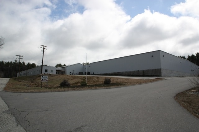
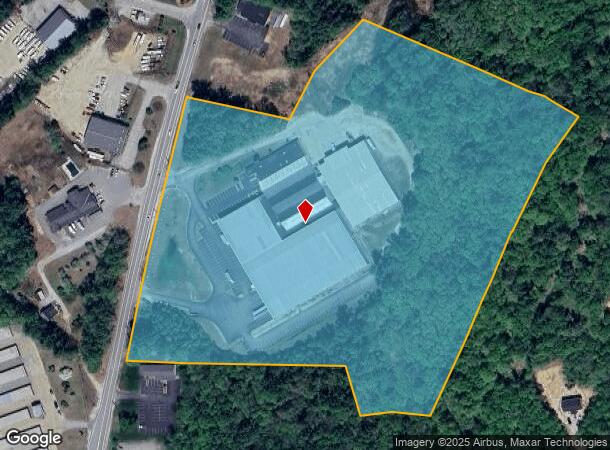
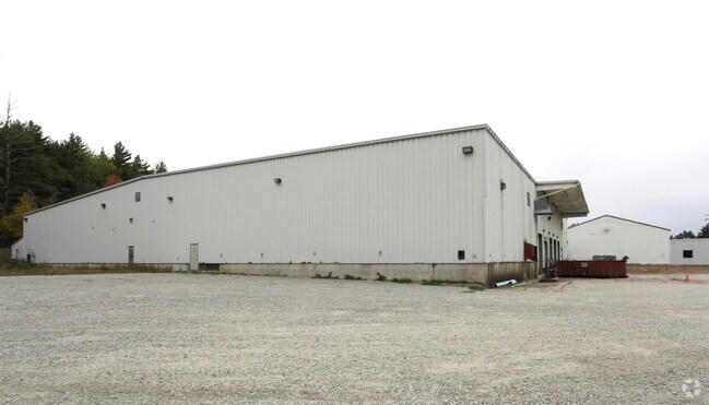
39 Sheep Davis Rd
Industrialgeneral
Merrimack
X
New Hampshire
33013C0561E
20.51 AC
2024
Concord/New Hampshire North Area
2024
Other Market Areas
003202
Concord, NH
14,210 SF
PMBR-000563-000000-000002
DEMOGRAPHICS near 39 Sheep Davis Rd
1 Mile
3 Mile
5 Mile
2024 Total Population
755
18,222
45,281
2029 Population
805
19,184
47,645
Pop Growth 2024-2029
+ 6.62%
+ 5.28%
+ 5.22%
Average Age
43
43
43
2024 Total Households
307
8,015
19,237
HH Growth 2024-2029
+ 6.19%
+ 5.15%
+ 5.21%
Median Household Inc
$91,826
$72,201
$75,885
Avg Household Size
2.40
2.20
2.20
2024 Avg HH Vehicles
2.00
2.00
2.00
Median Home Value
$287,096
$264,316
$300,061
Median Year Built
1977
1970
1970
Nearby Places
Map Layers
Map Styles
 Street
 Aerial
- Restaurants
- Banks
- Shops
- Fitness
- Groceries
PUBLIC TRANSPORTATION
AIRPORT
Manchester Boston Regional
DRIVE
WALK
Distance
Manchester Boston Regional
41 min
25.5 mi
Freight Ports
Port of Boston
DRIVE
WALK
Distance
Port of Boston
107 min
74.0 mi
SALE & LEASE HISTORY
LISTING DATE
SALE/LEASE

Mar 28, 2017
For Lease
Nearby Properties
Address
Land Use
TOTAL SIZE
Lot Size
Zoning
Address
Land Use
TOTAL SIZE
Lot Size
Zoning
293,984 SF
IS
Address
Land Use
TOTAL SIZE
Lot Size
Zoning
283,455 SF
80 AC
LO-A
Address
Land Use
TOTAL SIZE
Lot Size
Zoning
156 AC
IS
Address
Land Use
TOTAL SIZE
Lot Size
Zoning
65.25 AC
IN
Address
Land Use
TOTAL SIZE
Lot Size
Zoning
20 AC
RH
Address
Land Use
TOTAL SIZE
Lot Size
Zoning
11,576 SF
191 AC
C-1A
Address
Land Use
TOTAL SIZE
Lot Size
Zoning
147,477 SF
41.81 AC
R-1A
Address
Land Use
TOTAL SIZE
Lot Size
Zoning
41.49 AC
CG
Address
Land Use
TOTAL SIZE
Lot Size
Zoning
110 AC
IN
Address
Land Use
TOTAL SIZE
Lot Size
Zoning
75,917 SF
0.30 AC
CBP
Address
Land Use
TOTAL SIZE
Lot Size
Zoning
5 AC
C
Address
Land Use
TOTAL SIZE
Lot Size
Zoning
13.23 AC
RH
Address
Land Use
TOTAL SIZE
Lot Size
Zoning
142,137 SF
10.23 AC
OFP
Address
Land Use
TOTAL SIZE
Lot Size
Zoning
15.22 AC
OCP
Address
Land Use
TOTAL SIZE
Lot Size
Zoning
121,292 SF
10.69 AC
GWP
Address
Land Use
TOTAL SIZE
Lot Size
Zoning
41.95 AC
IN
Address
Land Use
TOTAL SIZE
Lot Size
Zoning
26.72 AC
IN
Address
Land Use
TOTAL SIZE
Lot Size
Zoning
50.19 AC
GWP
Address
Land Use
TOTAL SIZE
Lot Size
Zoning
114,620 SF
12.89 AC
GWP
Address
Land Use
TOTAL SIZE
Lot Size
Zoning
65,868 SF
10.60 AC
GWP
Address
Land Use
TOTAL SIZE
Lot Size
Zoning
132,828 SF
1.31 AC
CBP
Address
Land Use
TOTAL SIZE
Lot Size
Zoning
64,843 SF
6.60 AC
C
Address
Land Use
TOTAL SIZE
Lot Size
Zoning
76,705 SF
11.11 AC
CH
Address
Land Use
TOTAL SIZE
Lot Size
Zoning
100,826 SF
0.64 AC
IS
Address
Land Use
TOTAL SIZE
Lot Size
Zoning
63,634 SF
0.53 AC
CBP
Address
Land Use
TOTAL SIZE
Lot Size
Zoning
14.13 AC
GWP
Address
Land Use
TOTAL SIZE
Lot Size
Zoning
35,043 SF
10.40 AC
C
Address
Land Use
TOTAL SIZE
Lot Size
Zoning
5,052 SF
111.66 AC
RH
Address
Land Use
TOTAL SIZE
Lot Size
Zoning
98,070 SF
0.94 AC
IS
Address
Land Use
TOTAL SIZE
Lot Size
Zoning
7,475 SF
49.90 AC
C-1D
The World's #1 Commercial Real Estate Marketplace
Connect with us
© 2025 CoStar Group
The information above has been obtained from sources believed reliable. While we do not doubt its accuracy we have not verified it and make no guarantee, warranty or representation about it. It is your responsibility to independently confirm its accuracy and completeness. Any projections, opinions, assumptions, or estimates used are for example only and do not represent the current or future performance of the property. The value of this transaction to you depends on tax and other factors which should be evaluated by your tax, financial, and legal advisors. You and your advisors should conduct a careful, independent investigation of the property to determine to your satisfaction the suitability of the property for your needs.