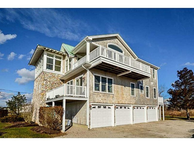
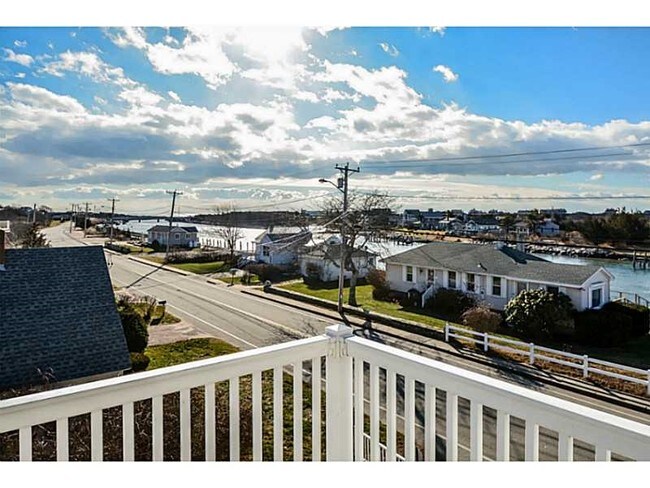
Property Record
39 Weekapaug Rd, Westerly, RI 02891

Property Detail
39 Weekapaug Rd
Condominium
Washington
AE
Rhode Island
44009C0259J
1
2025
Washington County
2025
Providence
051000
Providence-Warwick, RI-MA
946 SF
WEST-000143-000119-000001
NEARBY LISTINGS FOR SALE OR LEASE
-
-
View all Westerly listings for sale on LoopNet.com
DEMOGRAPHICS near 39 Weekapaug Rd
1 mile
3 mile
5 mile
2024 Total Population
2,063
8,341
28,143
2029 Population
2,206
8,793
28,559
Pop Growth 2024-2029
+ 6.93%
+ 5.42%
+ 1.48%
Average Age
52
51
47
2024 Total Households
932
3,765
12,634
HH Growth 2024-2029
+ 7.19%
+ 5.76%
+ 1.55%
Median Household Inc
$112,423
$113,351
$90,378
Avg Household Size
2.20
2.20
2.20
2024 Avg HH Vehicles
2.00
2.00
2.00
Median Home Value
$626,231
$571,507
$414,741
Median Year Built
1983
1981
1972
Nearby Places
Map Layers
Map Styles
 Street
 Aerial
Transit
 Traffic
 Biking
Places
Listings with unknown addresses are not visible on the map
- Restaurants
- Banks
- Shops
- Fitness
- Groceries
PUBLIC TRANSPORTATION
COMMUTER RAIL
Westerly Amtrak Station (Northeast Regional - Amtrak)
Drive
Walk
Distance
Westerly Amtrak Station (Northeast Regional - Amtrak)
9 min
5.6 mi
Freight Ports
Port of Davisville, RI
Drive
Walk
Distance
Port of Davisville, RI
51 min
33.1 mi
SALE & LEASE HISTORY
LISTING DATE
SALE/LEASE

Sep 05, 2017
For Sale
Oct 18, 2018
For Sale
Nearby Properties
Address
Land Use
TOTAL SIZE
Lot Size
Zoning
Address
Land Use
TOTAL SIZE
Lot Size
Zoning
157,662 SF
27.62 AC
Address
Land Use
TOTAL SIZE
Lot Size
Zoning
25.60 AC
Address
Land Use
TOTAL SIZE
Lot Size
Zoning
21.25 AC
Address
Land Use
TOTAL SIZE
Lot Size
Zoning
3,713 SF
1.80 AC
Address
Land Use
TOTAL SIZE
Lot Size
Zoning
5,785 SF
0.65 AC
Address
Land Use
TOTAL SIZE
Lot Size
Zoning
4,919 SF
0.95 AC
Address
Land Use
TOTAL SIZE
Lot Size
Zoning
290.30 AC
Address
Land Use
TOTAL SIZE
Lot Size
Zoning
5,500 SF
14.88 AC
Address
Land Use
TOTAL SIZE
Lot Size
Zoning
117,852 SF
19.78 AC
Address
Land Use
TOTAL SIZE
Lot Size
Zoning
4,910 SF
0.42 AC
Address
Land Use
TOTAL SIZE
Lot Size
Zoning
43,251 SF
Address
Land Use
TOTAL SIZE
Lot Size
Zoning
1.48 AC
Address
Land Use
TOTAL SIZE
Lot Size
Zoning
248.11 AC
Address
Land Use
TOTAL SIZE
Lot Size
Zoning
3,394 SF
0.64 AC
Address
Land Use
TOTAL SIZE
Lot Size
Zoning
3,590 SF
2.23 AC
Address
Land Use
TOTAL SIZE
Lot Size
Zoning
4,269 SF
0.92 AC
Address
Land Use
TOTAL SIZE
Lot Size
Zoning
4,291 SF
0.54 AC
Address
Land Use
TOTAL SIZE
Lot Size
Zoning
2.78 AC
R2A
Address
Land Use
TOTAL SIZE
Lot Size
Zoning
4,735 SF
1 AC
Address
Land Use
TOTAL SIZE
Lot Size
Zoning
3,430 SF
1.23 AC
Address
Land Use
TOTAL SIZE
Lot Size
Zoning
5,116 SF
Address
Land Use
TOTAL SIZE
Lot Size
Zoning
5,627 SF
1.23 AC
Address
Land Use
TOTAL SIZE
Lot Size
Zoning
7,412 SF
1.22 AC
Address
Land Use
TOTAL SIZE
Lot Size
Zoning
4,222 SF
2.97 AC
Address
Land Use
TOTAL SIZE
Lot Size
Zoning
4,950 SF
0.70 AC
Address
Land Use
TOTAL SIZE
Lot Size
Zoning
3,175 SF
2.97 AC
Address
Land Use
TOTAL SIZE
Lot Size
Zoning
7,177 SF
2.84 AC
Address
Land Use
TOTAL SIZE
Lot Size
Zoning
5,686 SF
1.53 AC
Address
Land Use
TOTAL SIZE
Lot Size
Zoning
2.12 AC
R2A
Address
Land Use
TOTAL SIZE
Lot Size
Zoning
4,332 SF
0.95 AC
The World's #1 Commercial Real Estate Marketplace
Connect with us
© 2026 CoStar Group
The information above has been obtained from sources believed reliable. While we do not doubt its accuracy we have not verified it and make no guarantee, warranty or representation about it. It is your responsibility to independently confirm its accuracy and completeness. Any projections, opinions, assumptions, or estimates used are for example only and do not represent the current or future performance of the property. The value of this transaction to you depends on tax and other factors which should be evaluated by your tax, financial, and legal advisors. You and your advisors should conduct a careful, independent investigation of the property to determine to your satisfaction the suitability of the property for your needs.