Property Record
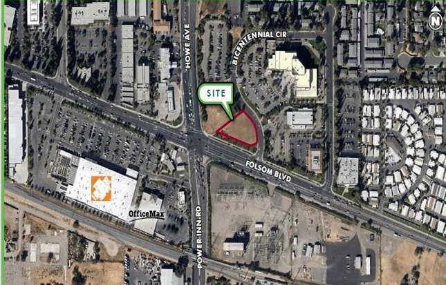
390 Bicentennial Cir, Sacramento, CA 95826
NEARBY LISTINGS FOR SALE OR LEASE
-
-
-
No Photo
-
SE Corner of Jackson Rd and Florin Perkins Rd Rd
Sacramento, CA 95826
$30,000 - $7,730,000
0.04 - 50.47 AC Lot
Land
-
-
-
-
-
-
-
View all Sacramento listings for lease on LoopNet.com
Property Detail
390 Bicentennial Cir
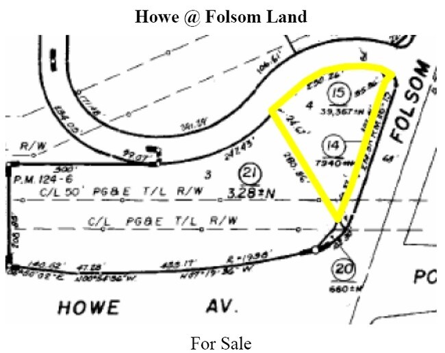
079-0420-015
Bicentennial Subdivision
Restaurantdrivein
PCL 4 PM BK 126 PG 6, EXC POR DES AS BEG AT MOST WL'Y COR SDPCL 4; TH FR SD POB N58%04'20E 22.82 FT; TH S71%43'32E302.41 FT; TH N63%16'28E 28.14 FT; TH CURVING RT ON RAD197.99 FT, CH BRG S15%29'11W 17.06 FT; TH S17%57'20W 0.85 FT;TH CURVING
X
Sacramento
06067C0195H
California
2024
0.90 AC
2025
Highway 50 Corridor
005205
Sacramento
4,745 SF
Sacramento--Roseville--Arden-Arcade, CA
DEMOGRAPHICS near 390 Bicentennial Cir
1 Mile
3 Mile
5 Mile
2024 Total Population
14,908
141,020
376,722
2029 Population
15,189
142,437
379,987
Pop Growth 2024-2029
+ 1.88%
+ 1.00%
+ 0.87%
Average Age
34
39
39
2024 Total Households
5,817
56,261
147,206
HH Growth 2024-2029
+ 2.37%
+ 1.07%
+ 0.97%
Median Household Inc
$58,075
$71,671
$67,712
Avg Household Size
2.10
2.30
2.40
2024 Avg HH Vehicles
2.00
2.00
2.00
Median Home Value
$435,323
$462,896
$448,233
Median Year Built
1973
1968
1967
Nearby Places
Map Layers
Map Styles
 Street
 Aerial
- Restaurants
- Banks
- Shops
- Fitness
- Groceries
PUBLIC TRANSPORTATION
TRANSIT/SUBWAY
Power Inn (Gold Line - Sacramento Regional Transit District Light Rail (The RT))
DRIVE
WALK
Distance
Power Inn (Gold Line - Sacramento Regional Transit District Light Rail (The RT))
1 min
7 min
0.4 mi
College Greens (Gold Line - Sacramento Regional Transit District Light Rail (The RT))
DRIVE
WALK
Distance
College Greens (Gold Line - Sacramento Regional Transit District Light Rail (The RT))
2 min
16 min
0.9 mi
COMMUTER RAIL
Sacramento (Capitol Corridor - Capitol Corridor Joint Powers Authority)
DRIVE
WALK
Distance
Sacramento (Capitol Corridor - Capitol Corridor Joint Powers Authority)
11 min
6.0 mi
AIRPORT
Sacramento International
DRIVE
WALK
Distance
Sacramento International
25 min
17.8 mi
Freight Ports
Port of Stockton
DRIVE
WALK
Distance
Port of Stockton
61 min
51.4 mi
SALE & LEASE HISTORY
LISTING DATE
SALE/LEASE

Sep 13, 2017
For Lease
Nearby Properties
Address
Land Use
TOTAL SIZE
Lot Size
Zoning
Address
Land Use
TOTAL SIZE
Lot Size
Zoning
10.28 AC
H
Address
Land Use
TOTAL SIZE
Lot Size
Zoning
7,742 SF
12.66 AC
M-1S-SWR
Address
Land Use
TOTAL SIZE
Lot Size
Zoning
299,943 SF
4.95 AC
H
Address
Land Use
TOTAL SIZE
Lot Size
Zoning
1.33 AC
R-1
Address
Land Use
TOTAL SIZE
Lot Size
Zoning
2,317,288 SF
220.58 AC
M-2-SPD
Address
Land Use
TOTAL SIZE
Lot Size
Zoning
9.29 AC
R-1 OB-R-P
Address
Land Use
TOTAL SIZE
Lot Size
Zoning
1.15 AC
R-1
Address
Land Use
TOTAL SIZE
Lot Size
Zoning
490,607 SF
32.63 AC
RD-30
Address
Land Use
TOTAL SIZE
Lot Size
Zoning
31,163 SF
1.57 AC
C-2-TO-SPD
Address
Land Use
TOTAL SIZE
Lot Size
Zoning
350,049 SF
8.51 AC
MRD-SWR
Address
Land Use
TOTAL SIZE
Lot Size
Zoning
45.93 AC
M-2S
Address
Land Use
TOTAL SIZE
Lot Size
Zoning
281,448 SF
13.42 AC
RMX-TO R-2
Address
Land Use
TOTAL SIZE
Lot Size
Zoning
320,072 SF
2.65 AC
C-2
Address
Land Use
TOTAL SIZE
Lot Size
Zoning
149,566 SF
9.68 AC
M-2S
Address
Land Use
TOTAL SIZE
Lot Size
Zoning
179,178 SF
3.35 AC
RO
Address
Land Use
TOTAL SIZE
Lot Size
Zoning
2.59 AC
OB-R
Address
Land Use
TOTAL SIZE
Lot Size
Zoning
119,380 SF
18.92 AC
M-2S
Address
Land Use
TOTAL SIZE
Lot Size
Zoning
1.15 AC
R-1
Address
Land Use
TOTAL SIZE
Lot Size
Zoning
148,642 SF
7.15 AC
RD-30
Address
Land Use
TOTAL SIZE
Lot Size
Zoning
156,462 SF
8.36 AC
R-3
Address
Land Use
TOTAL SIZE
Lot Size
Zoning
40.67 AC
M-2-SPD
Address
Land Use
TOTAL SIZE
Lot Size
Zoning
584,820 SF
29.12 AC
M-2S
Address
Land Use
TOTAL SIZE
Lot Size
Zoning
190,723 SF
9.10 AC
RD-30
Address
Land Use
TOTAL SIZE
Lot Size
Zoning
345,600 SF
14.84 AC
M-1S-SWR
Address
Land Use
TOTAL SIZE
Lot Size
Zoning
164,981 SF
3.95 AC
OB-SWR-PUD
Address
Land Use
TOTAL SIZE
Lot Size
Zoning
53,386 SF
7.75 AC
C-2-SPD
Address
Land Use
TOTAL SIZE
Lot Size
Zoning
171,405 SF
13.80 AC
R-1
Address
Land Use
TOTAL SIZE
Lot Size
Zoning
192,308 SF
5.42 AC
C-2
Address
Land Use
TOTAL SIZE
Lot Size
Zoning
303,950 SF
19.34 AC
R-2A-R
Address
Land Use
TOTAL SIZE
Lot Size
Zoning
82,936 SF
7.66 AC
SC-PUD
The World's #1 Commercial Real Estate Marketplace
Connect with us
© 2025 CoStar Group
The information above has been obtained from sources believed reliable. While we do not doubt its accuracy we have not verified it and make no guarantee, warranty or representation about it. It is your responsibility to independently confirm its accuracy and completeness. Any projections, opinions, assumptions, or estimates used are for example only and do not represent the current or future performance of the property. The value of this transaction to you depends on tax and other factors which should be evaluated by your tax, financial, and legal advisors. You and your advisors should conduct a careful, independent investigation of the property to determine to your satisfaction the suitability of the property for your needs.