Property Record
390 Capistrano Rd, El Granada, CA 94018

Save to a Folder
{{folder.Name}}
{{folder.ListingIds.length}} Properties
{{folder.ListingIds.length}} Property
Create a New Folder
Property Detail
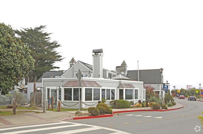
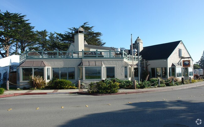
390 Capistrano Rd
047-081-450
1.32 AC MOL ON NLY LN OF CAPISTRANO RD BND NLY & NWLY BY PAR C PM VOL 67/90-91 ACREAGE CABRILLO UNIF SCH DIST
Restaurantbuilding
SAN MATEO
H10000
California
C and X Area of minimal flood hazard, usually depicted on FIRMs as above the 500-year flood level.
1.32 AC
2025
Peninsula Coastline
2026
San Francisco
613502
San Francisco-San Mateo-Redwood City, CA
NEARBY LISTINGS FOR SALE OR LEASE
-
-
View all El Granada listings for sale on LoopNet.com
DEMOGRAPHICS near 390 Capistrano Rd
1 mile
3 mile
5 mile
2025 Total Population
3,972
10,938
19,045
2030 Population
3,844
10,587
18,671
Pop Growth 2025-2030
(3.22%)
(3.21%)
(1.96%)
Average Age
44
46
46
2025 Total Households
1,451
3,996
6,928
HH Growth 2025-2030
(3.51%)
(3.48%)
(2.09%)
Median Household Inc
$146,577
$187,244
$161,903
Avg Household Size
2.60
2.60
2.60
2025 Avg HH Vehicles
3.00
3.00
2.00
Median Home Value
$1,076,327
$1,103,427
$1,094,139
Median Year Built
1977
1978
1978
Nearby Places
Map Layers
Map Styles
 Street
 Aerial
Layers
 Traffic
 Biking
Places
Listings with unknown addresses are not visible on the map
- Restaurants
- Banks
- Shops
- Fitness
- Groceries
PUBLIC TRANSPORTATION
AIRPORT
San Francisco International
Drive
Walk
Distance
San Francisco International
33 min
18.7 mi
Metro Oakland International
Drive
Walk
Distance
Metro Oakland International
57 min
40.7 mi
Norman Y Mineta San Jose International
Drive
Walk
Distance
Norman Y Mineta San Jose International
58 min
42.0 mi
Freight Ports
Port of Redwood City
Drive
Walk
Distance
Port of Redwood City
39 min
24.8 mi
Nearby Properties
Address
Land Use
TOTAL SIZE
Lot Size
Zoning
Address
Land Use
TOTAL SIZE
Lot Size
Zoning
94,688 SF
3.54 AC
H10000
Address
Land Use
TOTAL SIZE
Lot Size
Zoning
6.21 AC
R10S17
Address
Land Use
TOTAL SIZE
Lot Size
Zoning
20.61 AC
Address
Land Use
TOTAL SIZE
Lot Size
Zoning
Address
Land Use
TOTAL SIZE
Lot Size
Zoning
15,724 SF
0.37 AC
R300S3
Address
Land Use
TOTAL SIZE
Lot Size
Zoning
7,295 SF
1.30 AC
RM0000
Address
Land Use
TOTAL SIZE
Lot Size
Zoning
10,883 SF
0.25 AC
R20000
Address
Land Use
TOTAL SIZE
Lot Size
Zoning
24,275 SF
1.74 AC
Address
Land Use
TOTAL SIZE
Lot Size
Zoning
5,290 SF
0.31 AC
R300S
Address
Land Use
TOTAL SIZE
Lot Size
Zoning
12,675 SF
0.60 AC
Address
Land Use
TOTAL SIZE
Lot Size
Zoning
34,320 SF
1.67 AC
M10000
Address
Land Use
TOTAL SIZE
Lot Size
Zoning
5,856 SF
0.19 AC
R30000
Address
Land Use
TOTAL SIZE
Lot Size
Zoning
0.18 AC
R30000
Address
Land Use
TOTAL SIZE
Lot Size
Zoning
5.48 AC
Address
Land Use
TOTAL SIZE
Lot Size
Zoning
178.20 AC
RM0000
Address
Land Use
TOTAL SIZE
Lot Size
Zoning
12,262 SF
0.19 AC
C100S1
Address
Land Use
TOTAL SIZE
Lot Size
Zoning
6,500 SF
0.32 AC
H10000
Address
Land Use
TOTAL SIZE
Lot Size
Zoning
10,980 SF
0.48 AC
MAR0DR
Address
Land Use
TOTAL SIZE
Lot Size
Zoning
11,700 SF
0.40 AC
MAR0DR
Address
Land Use
TOTAL SIZE
Lot Size
Zoning
Address
Land Use
TOTAL SIZE
Lot Size
Zoning
3,540 SF
0.16 AC
ML00M1
Address
Land Use
TOTAL SIZE
Lot Size
Zoning
3.42 AC
R10006
Address
Land Use
TOTAL SIZE
Lot Size
Zoning
161,809 SF
8.86 AC
A10000
Address
Land Use
TOTAL SIZE
Lot Size
Zoning
17,100 SF
0.80 AC
Address
Land Use
TOTAL SIZE
Lot Size
Zoning
9,756 SF
0.32 AC
Address
Land Use
TOTAL SIZE
Lot Size
Zoning
0.88 AC
R10000
Address
Land Use
TOTAL SIZE
Lot Size
Zoning
6,852 SF
0.34 AC
CL00C1
Address
Land Use
TOTAL SIZE
Lot Size
Zoning
4,209 SF
0.18 AC
Address
Land Use
TOTAL SIZE
Lot Size
Zoning
4,260 SF
0.18 AC
CL00C1
The World's #1 Commercial Real Estate Marketplace
Connect with us
© 2026 CoStar Group
The information above has been obtained from sources believed reliable. While we do not doubt its accuracy we have not verified it and make no guarantee, warranty or representation about it. It is your responsibility to independently confirm its accuracy and completeness. Any projections, opinions, assumptions, or estimates used are for example only and do not represent the current or future performance of the property. The value of this transaction to you depends on tax and other factors which should be evaluated by your tax, financial, and legal advisors. You and your advisors should conduct a careful, independent investigation of the property to determine to your satisfaction the suitability of the property for your needs.