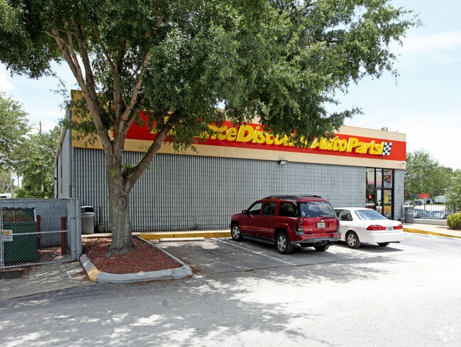
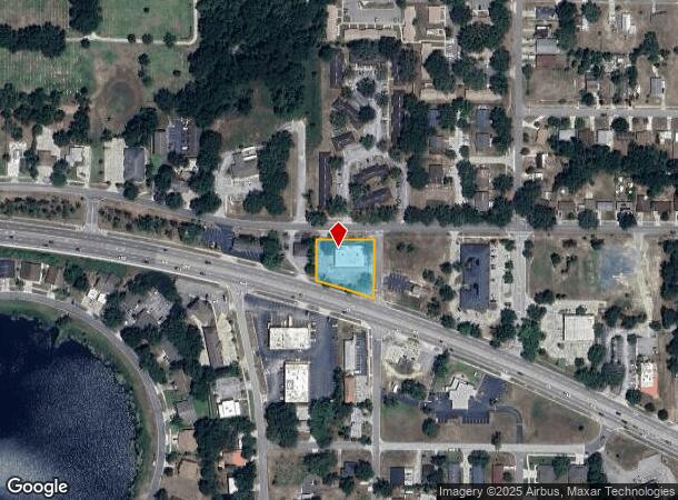
Property Record
390 E Highway 50, Clermont, FL 34711

NEARBY LISTINGS FOR SALE OR LEASE
Property Detail
390 E Highway 50
Orlando-Kissimmee-Sanford, FL
Clermont Clermont Heights
30-22-26-0400-000-10200
CLERMONT CLERMONT HEIGHTS THAT PART OF LOTS 102 & 103 LYING E OF A LINE DESCRIBED AS FROM INTERSECTION OF WLY R/W LINE OF ANDERSON ST & SLY R/W LINE OF HIGHLAND AVE PER CITY ORDINANCE NO 59-M RUN NWLY ALONG S LINE OF HIGHLAND AVE 179.99 FT FOR POB RU
Storemultistory
Lake
X
Florida
12069C0570E
102
2024
0.64 AC
2026
Lake County
031312
Orlando
5,850 SF
DEMOGRAPHICS near 390 E Highway 50
1 Mile
3 Mile
5 Mile
2024 Total Population
7,522
45,991
104,297
2029 Population
8,608
53,429
122,176
Pop Growth 2024-2029
+ 14.44%
+ 16.17%
+ 17.14%
Average Age
40
40
42
2024 Total Households
3,000
16,799
38,471
HH Growth 2024-2029
+ 14.37%
+ 15.91%
+ 16.90%
Median Household Inc
$57,558
$80,797
$82,409
Avg Household Size
2.40
2.70
2.70
2024 Avg HH Vehicles
2.00
2.00
2.00
Median Home Value
$256,324
$319,683
$319,128
Median Year Built
1978
2002
2004
Nearby Places
Map Layers
Map Styles
 Street
 Aerial
- Restaurants
- Banks
- Shops
- Fitness
- Groceries
PUBLIC TRANSPORTATION
AIRPORT
Orlando International
DRIVE
WALK
Distance
Orlando International
45 min
33.1 mi
SALE & LEASE HISTORY
LISTING DATE
SALE/LEASE

Jun 16, 2025
For Sale
Apr 07, 2025
For Lease
Nearby Properties
Address
Land Use
TOTAL SIZE
Lot Size
Zoning
Address
Land Use
TOTAL SIZE
Lot Size
Zoning
403,970 SF
30.99 AC
PUD
Address
Land Use
TOTAL SIZE
Lot Size
Zoning
337,218 SF
16.38 AC
Address
Land Use
TOTAL SIZE
Lot Size
Zoning
285,581 SF
19.34 AC
CFD
Address
Land Use
TOTAL SIZE
Lot Size
Zoning
326,899 SF
20.77 AC
Address
Land Use
TOTAL SIZE
Lot Size
Zoning
299,214 SF
25.01 AC
PUD
Address
Land Use
TOTAL SIZE
Lot Size
Zoning
321,012 SF
22.55 AC
PUD
Address
Land Use
TOTAL SIZE
Lot Size
Zoning
2,000 SF
35.96 AC
PUD
Address
Land Use
TOTAL SIZE
Lot Size
Zoning
269,594 SF
25.23 AC
PUD
Address
Land Use
TOTAL SIZE
Lot Size
Zoning
179,290 SF
23.79 AC
Address
Land Use
TOTAL SIZE
Lot Size
Zoning
212,649 SF
4.20 AC
Address
Land Use
TOTAL SIZE
Lot Size
Zoning
192,907 SF
16.43 AC
PUD
Address
Land Use
TOTAL SIZE
Lot Size
Zoning
2,000 SF
26.79 AC
PUD
Address
Land Use
TOTAL SIZE
Lot Size
Zoning
273,592 SF
91.55 AC
R6
Address
Land Use
TOTAL SIZE
Lot Size
Zoning
Address
Land Use
TOTAL SIZE
Lot Size
Zoning
52,986 SF
18.27 AC
Address
Land Use
TOTAL SIZE
Lot Size
Zoning
2,000 SF
30.62 AC
CFD
Address
Land Use
TOTAL SIZE
Lot Size
Zoning
2,000 SF
63.78 AC
Address
Land Use
TOTAL SIZE
Lot Size
Zoning
124,634 SF
18.57 AC
Address
Land Use
TOTAL SIZE
Lot Size
Zoning
142,824 SF
9.90 AC
C2
Address
Land Use
TOTAL SIZE
Lot Size
Zoning
126,067 SF
9.34 AC
Address
Land Use
TOTAL SIZE
Lot Size
Zoning
62,794 SF
2.31 AC
Address
Land Use
TOTAL SIZE
Lot Size
Zoning
203,762 SF
18.28 AC
R1
Address
Land Use
TOTAL SIZE
Lot Size
Zoning
227,034 SF
29.20 AC
Address
Land Use
TOTAL SIZE
Lot Size
Zoning
109,254 SF
5.54 AC
Address
Land Use
TOTAL SIZE
Lot Size
Zoning
95,182 SF
12.34 AC
PUD
Address
Land Use
TOTAL SIZE
Lot Size
Zoning
102,086 SF
5.32 AC
Address
Land Use
TOTAL SIZE
Lot Size
Zoning
158,351 SF
19.10 AC
C2
Address
Land Use
TOTAL SIZE
Lot Size
Zoning
178,735 SF
20.68 AC
PUD
Address
Land Use
TOTAL SIZE
Lot Size
Zoning
87,951 SF
5.88 AC
Address
Land Use
TOTAL SIZE
Lot Size
Zoning
80,774 SF
6.61 AC
The World's #1 Commercial Real Estate Marketplace
Connect with us
© 2025 CoStar Group
The information above has been obtained from sources believed reliable. While we do not doubt its accuracy we have not verified it and make no guarantee, warranty or representation about it. It is your responsibility to independently confirm its accuracy and completeness. Any projections, opinions, assumptions, or estimates used are for example only and do not represent the current or future performance of the property. The value of this transaction to you depends on tax and other factors which should be evaluated by your tax, financial, and legal advisors. You and your advisors should conduct a careful, independent investigation of the property to determine to your satisfaction the suitability of the property for your needs.