Property Record
5432 W Escuda Rd, Avondale, AZ 85323
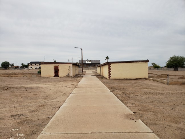
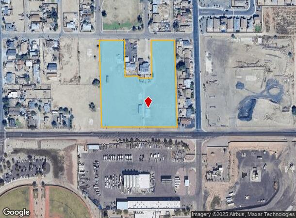
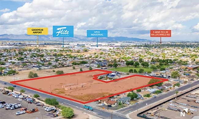
This Property Is For Sale
NEARBY LISTINGS FOR SALE OR LEASE
Property Detail
5432 W Escuda Rd
Phoenix-Mesa-Chandler, AZ
Rnls Properties Lot Split Mld
500-56-043
Maricopa
Duplex
Arizona
X
5.81 AC
04013C2165P
West I-10
1,987 SF
Phoenix
DEMOGRAPHICS near 5432 W Escuda Rd
1 Mile
3 Mile
5 Mile
2024 Total Population
8,559
52,037
164,510
2029 Population
9,242
56,361
179,134
Pop Growth 2024-2029
+ 7.98%
+ 8.31%
+ 8.89%
Average Age
32
33
35
2024 Total Households
2,467
15,310
51,021
HH Growth 2024-2029
+ 8.11%
+ 8.48%
+ 9.04%
Median Household Inc
$48,569
$68,206
$79,557
Avg Household Size
3.40
3.30
3.10
2024 Avg HH Vehicles
2.00
2.00
2.00
Median Home Value
$258,041
$285,893
$336,688
Median Year Built
1990
2001
2004
Nearby Places
Map Layers
Map Styles
 Street
 Aerial
- Restaurants
- Banks
- Shops
- Fitness
- Groceries
PUBLIC TRANSPORTATION
AIRPORT
Phoenix Sky Harbor International
DRIVE
WALK
Distance
Phoenix Sky Harbor International
34 min
24.6 mi
Freight Ports
Port of San Diego
DRIVE
WALK
Distance
Port of San Diego
381 min
341.5 mi
Nearby Properties
Address
Land Use
TOTAL SIZE
Lot Size
Zoning
Address
Land Use
TOTAL SIZE
Lot Size
Zoning
16.70 AC
Address
Land Use
TOTAL SIZE
Lot Size
Zoning
12.80 AC
Address
Land Use
TOTAL SIZE
Lot Size
Zoning
206.08 AC
PAD
Address
Land Use
TOTAL SIZE
Lot Size
Zoning
49,475 SF
5.70 AC
PAD
Address
Land Use
TOTAL SIZE
Lot Size
Zoning
370,726 SF
23.41 AC
PAD
Address
Land Use
TOTAL SIZE
Lot Size
Zoning
324,374 SF
18.26 AC
PAD
Address
Land Use
TOTAL SIZE
Lot Size
Zoning
90,008 SF
20.42 AC
M-H
Address
Land Use
TOTAL SIZE
Lot Size
Zoning
563,328 SF
24.43 AC
C2
Address
Land Use
TOTAL SIZE
Lot Size
Zoning
901,699 SF
49.92 AC
I1
Address
Land Use
TOTAL SIZE
Lot Size
Zoning
301,329 SF
50.60 AC
AG
Address
Land Use
TOTAL SIZE
Lot Size
Zoning
855,336 SF
45.11 AC
Address
Land Use
TOTAL SIZE
Lot Size
Zoning
802,671 SF
48.81 AC
I1
Address
Land Use
TOTAL SIZE
Lot Size
Zoning
790,980 SF
42.95 AC
I1
Address
Land Use
TOTAL SIZE
Lot Size
Zoning
78 AC
AG
Address
Land Use
TOTAL SIZE
Lot Size
Zoning
663,150 SF
34.49 AC
Address
Land Use
TOTAL SIZE
Lot Size
Zoning
450,619 SF
28.95 AC
I2
Address
Land Use
TOTAL SIZE
Lot Size
Zoning
54,562 SF
7.65 AC
PAD
Address
Land Use
TOTAL SIZE
Lot Size
Zoning
422,300 SF
21.26 AC
I1
Address
Land Use
TOTAL SIZE
Lot Size
Zoning
229,266 SF
10.25 AC
PAD
Address
Land Use
TOTAL SIZE
Lot Size
Zoning
9.73 AC
AU
Address
Land Use
TOTAL SIZE
Lot Size
Zoning
191,303 SF
37.42 AC
R-6
Address
Land Use
TOTAL SIZE
Lot Size
Zoning
6,472 SF
1.14 AC
PAD
Address
Land Use
TOTAL SIZE
Lot Size
Zoning
232,797 SF
25.43 AC
PAD
Address
Land Use
TOTAL SIZE
Lot Size
Zoning
1,038,407 SF
59.55 AC
R-43
Address
Land Use
TOTAL SIZE
Lot Size
Zoning
291,805 SF
16.48 AC
PAD
Address
Land Use
TOTAL SIZE
Lot Size
Zoning
457,432 SF
29.78 AC
Address
Land Use
TOTAL SIZE
Lot Size
Zoning
60,562 SF
597.40 AC
AG
Address
Land Use
TOTAL SIZE
Lot Size
Zoning
450,240 SF
25.56 AC
Address
Land Use
TOTAL SIZE
Lot Size
Zoning
299,050 SF
16.29 AC
A1
Address
Land Use
TOTAL SIZE
Lot Size
Zoning
93,605 SF
10.99 AC
PAD
The World's #1 Commercial Real Estate Marketplace
Connect with us
© 2026 CoStar Group
The information above has been obtained from sources believed reliable. While we do not doubt its accuracy we have not verified it and make no guarantee, warranty or representation about it. It is your responsibility to independently confirm its accuracy and completeness. Any projections, opinions, assumptions, or estimates used are for example only and do not represent the current or future performance of the property. The value of this transaction to you depends on tax and other factors which should be evaluated by your tax, financial, and legal advisors. You and your advisors should conduct a careful, independent investigation of the property to determine to your satisfaction the suitability of the property for your needs.