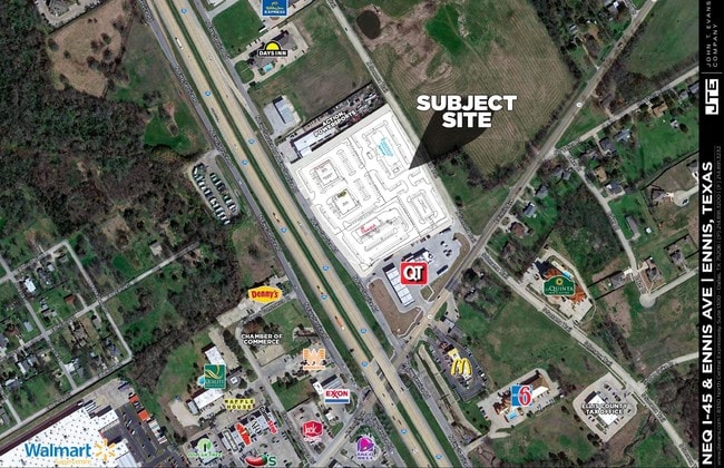
Property Record
390 N Interstate Highway 45, Ennis, TX 75119

Save to a Folder
{{folder.Name}}
{{folder.ListingIds.length}} Properties
{{folder.ListingIds.length}} Property
Create a New Folder
Property Detail
390 N Interstate Highway 45
Dallas-Fort Worth-Arlington, TX
LOT 3 ENNIS CROSSING ADDN 1.703 AC
275590
ELLIS
Commercialnec
Texas
B and X Area of moderate flood hazard, usually the area between the limits of the 100-year and 500-year floods.
3
2024
1.70 AC
2025
Southeast Outlying
061600
Dallas/Ft Worth
4,836 SF
NEARBY LISTINGS FOR SALE OR LEASE
DEMOGRAPHICS near 390 N Interstate Highway 45
1 mile
3 mile
5 mile
2025 Total Population
5,107
25,810
28,949
2030 Population
5,943
30,079
33,717
Pop Growth 2025-2030
+ 16.37%
+ 16.54%
+ 16.47%
Average Age
35
36
37
2025 Total Households
1,680
8,811
9,900
HH Growth 2025-2030
+ 16.37%
+ 16.63%
+ 16.56%
Median Household Inc
$65,244
$68,238
$70,149
Avg Household Size
3.00
2.80
2.80
2025 Avg HH Vehicles
2.00
2.00
2.00
Median Home Value
$164,024
$239,392
$255,596
Median Year Built
1993
1992
1992
Nearby Places
Map Layers
Map Styles
 Street
 Aerial
Layers
 Traffic
 Biking
Places
Listings with unknown addresses are not visible on the map
- Restaurants
- Banks
- Shops
- Fitness
- Groceries
SALE & LEASE HISTORY
LISTING DATE
SALE/LEASE

Nov 08, 2019
For Lease
Nearby Properties
Address
Land Use
TOTAL SIZE
Lot Size
Zoning
Address
Land Use
TOTAL SIZE
Lot Size
Zoning
253.82 AC
Address
Land Use
TOTAL SIZE
Lot Size
Zoning
908,121 SF
211.87 AC
Address
Land Use
TOTAL SIZE
Lot Size
Zoning
219,936 SF
12.88 AC
Address
Land Use
TOTAL SIZE
Lot Size
Zoning
123,972 SF
18.13 AC
Address
Land Use
TOTAL SIZE
Lot Size
Zoning
419,714 SF
34.32 AC
Address
Land Use
TOTAL SIZE
Lot Size
Zoning
309,344 SF
12.90 AC
Address
Land Use
TOTAL SIZE
Lot Size
Zoning
250,382 SF
36.10 AC
Address
Land Use
TOTAL SIZE
Lot Size
Zoning
291,675 SF
17.10 AC
Address
Land Use
TOTAL SIZE
Lot Size
Zoning
101,700 SF
24.70 AC
Address
Land Use
TOTAL SIZE
Lot Size
Zoning
449,750 SF
22.33 AC
Address
Land Use
TOTAL SIZE
Lot Size
Zoning
69,375 SF
31.57 AC
Address
Land Use
TOTAL SIZE
Lot Size
Zoning
65,756 SF
6.94 AC
Address
Land Use
TOTAL SIZE
Lot Size
Zoning
184,050 SF
19.46 AC
Address
Land Use
TOTAL SIZE
Lot Size
Zoning
54,156 SF
12.59 AC
Address
Land Use
TOTAL SIZE
Lot Size
Zoning
63,831 SF
19.71 AC
Address
Land Use
TOTAL SIZE
Lot Size
Zoning
98,935 SF
4.41 AC
Address
Land Use
TOTAL SIZE
Lot Size
Zoning
40,154 SF
15.15 AC
Address
Land Use
TOTAL SIZE
Lot Size
Zoning
300,744 SF
51.57 AC
Address
Land Use
TOTAL SIZE
Lot Size
Zoning
105,050 SF
4.34 AC
Address
Land Use
TOTAL SIZE
Lot Size
Zoning
38,065 SF
6.96 AC
Address
Land Use
TOTAL SIZE
Lot Size
Zoning
102,000 SF
22.87 AC
Address
Land Use
TOTAL SIZE
Lot Size
Zoning
203,790 SF
40.38 AC
Address
Land Use
TOTAL SIZE
Lot Size
Zoning
237,817 SF
12.97 AC
Address
Land Use
TOTAL SIZE
Lot Size
Zoning
229,950 SF
15.53 AC
Address
Land Use
TOTAL SIZE
Lot Size
Zoning
311,250 SF
29.40 AC
Address
Land Use
TOTAL SIZE
Lot Size
Zoning
100,636 SF
7.08 AC
Address
Land Use
TOTAL SIZE
Lot Size
Zoning
83,172 SF
5.69 AC
Address
Land Use
TOTAL SIZE
Lot Size
Zoning
116,051 SF
9.17 AC
Address
Land Use
TOTAL SIZE
Lot Size
Zoning
93,758 SF
12.66 AC
Address
Land Use
TOTAL SIZE
Lot Size
Zoning
3,796 SF
11.16 AC
The World's #1 Commercial Real Estate Marketplace
Connect with us
© 2026 CoStar Group
The information above has been obtained from sources believed reliable. While we do not doubt its accuracy we have not verified it and make no guarantee, warranty or representation about it. It is your responsibility to independently confirm its accuracy and completeness. Any projections, opinions, assumptions, or estimates used are for example only and do not represent the current or future performance of the property. The value of this transaction to you depends on tax and other factors which should be evaluated by your tax, financial, and legal advisors. You and your advisors should conduct a careful, independent investigation of the property to determine to your satisfaction the suitability of the property for your needs.