No Photo
Property Record
390 Se Church St, Sublimity, OR 97385
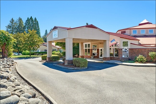

Property Detail
390 Se Church St
105524
SUBLIMITY TOWN PLAT BLOCK 21 LOT FR 7-9 ACRES 3.00
Officebuilding
Marion
C
Oregon
B and X Area of moderate flood hazard, usually the area between the limits of the 100-year and 500-year floods.
7-9
2024
3 AC
2025
Outlying Marion County
010702
Portland
32,488 SF
Salem, OR
NEARBY LISTINGS FOR SALE OR LEASE
-
-
View all Sublimity listings for sale on LoopNet.com
DEMOGRAPHICS near 390 Se Church St
1 mile
3 mile
5 mile
2024 Total Population
3,617
13,411
20,174
2029 Population
3,741
13,674
20,478
Pop Growth 2024-2029
+ 3.43%
+ 1.96%
+ 1.51%
Average Age
47
42
41
2024 Total Households
1,370
5,006
7,305
HH Growth 2024-2029
+ 3.58%
+ 2.12%
+ 1.70%
Median Household Inc
$77,056
$72,332
$77,690
Avg Household Size
2.40
2.60
2.70
2024 Avg HH Vehicles
2.00
2.00
2.00
Median Home Value
$487,830
$464,770
$457,442
Median Year Built
1995
1989
1988
Nearby Places
Map Layers
Map Styles
 Street
 Aerial
Transit
 Traffic
 Biking
Places
Listings with unknown addresses are not visible on the map
- Restaurants
- Banks
- Shops
- Fitness
- Groceries
Nearby Properties
Address
Land Use
TOTAL SIZE
Lot Size
Zoning
Address
Land Use
TOTAL SIZE
Lot Size
Zoning
110,833 SF
7.20 AC
P
Address
Land Use
TOTAL SIZE
Lot Size
Zoning
Address
Land Use
TOTAL SIZE
Lot Size
Zoning
Address
Land Use
TOTAL SIZE
Lot Size
Zoning
15.76 AC
IL
Address
Land Use
TOTAL SIZE
Lot Size
Zoning
103,745 SF
5.02 AC
HD; CG
Address
Land Use
TOTAL SIZE
Lot Size
Zoning
7.25 AC
IL
Address
Land Use
TOTAL SIZE
Lot Size
Zoning
549,542 SF
50.91 AC
IL; LD
Address
Land Use
TOTAL SIZE
Lot Size
Zoning
4 AC
P; R-1
Address
Land Use
TOTAL SIZE
Lot Size
Zoning
53,890 SF
3.27 AC
HD
Address
Land Use
TOTAL SIZE
Lot Size
Zoning
29,891 SF
10.75 AC
ID; P; AR
Address
Land Use
TOTAL SIZE
Lot Size
Zoning
32,552 SF
7.47 AC
P
Address
Land Use
TOTAL SIZE
Lot Size
Zoning
47,638 SF
7.48 AC
CG
Address
Land Use
TOTAL SIZE
Lot Size
Zoning
49,450 SF
1.20 AC
C
Address
Land Use
TOTAL SIZE
Lot Size
Zoning
42,969 SF
4.10 AC
CG
Address
Land Use
TOTAL SIZE
Lot Size
Zoning
35,837 SF
2.94 AC
C
Address
Land Use
TOTAL SIZE
Lot Size
Zoning
27,787 SF
2.19 AC
C
Address
Land Use
TOTAL SIZE
Lot Size
Zoning
174,640 SF
15 AC
IL
Address
Land Use
TOTAL SIZE
Lot Size
Zoning
188,422 SF
95 AC
EFU
Address
Land Use
TOTAL SIZE
Lot Size
Zoning
Address
Land Use
TOTAL SIZE
Lot Size
Zoning
27,060 SF
2.36 AC
MD
Address
Land Use
TOTAL SIZE
Lot Size
Zoning
21,704 SF
110.82 AC
UT-20
Address
Land Use
TOTAL SIZE
Lot Size
Zoning
39,168 SF
2.33 AC
HD
Address
Land Use
TOTAL SIZE
Lot Size
Zoning
25,566 SF
3.49 AC
P
Address
Land Use
TOTAL SIZE
Lot Size
Zoning
41,871 SF
3 AC
CG; CR
Address
Land Use
TOTAL SIZE
Lot Size
Zoning
8.22 AC
IL
Address
Land Use
TOTAL SIZE
Lot Size
Zoning
20,200 SF
6.05 AC
IL
Address
Land Use
TOTAL SIZE
Lot Size
Zoning
32,736 SF
1.92 AC
HD
Address
Land Use
TOTAL SIZE
Lot Size
Zoning
69,292 SF
8.36 AC
IL
Address
Land Use
TOTAL SIZE
Lot Size
Zoning
33,954 SF
1.59 AC
R-2
The World's #1 Commercial Real Estate Marketplace
Connect with us
© 2026 CoStar Group
The information above has been obtained from sources believed reliable. While we do not doubt its accuracy we have not verified it and make no guarantee, warranty or representation about it. It is your responsibility to independently confirm its accuracy and completeness. Any projections, opinions, assumptions, or estimates used are for example only and do not represent the current or future performance of the property. The value of this transaction to you depends on tax and other factors which should be evaluated by your tax, financial, and legal advisors. You and your advisors should conduct a careful, independent investigation of the property to determine to your satisfaction the suitability of the property for your needs.