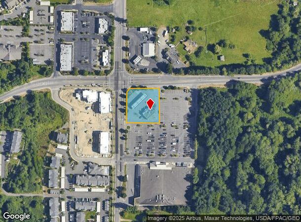
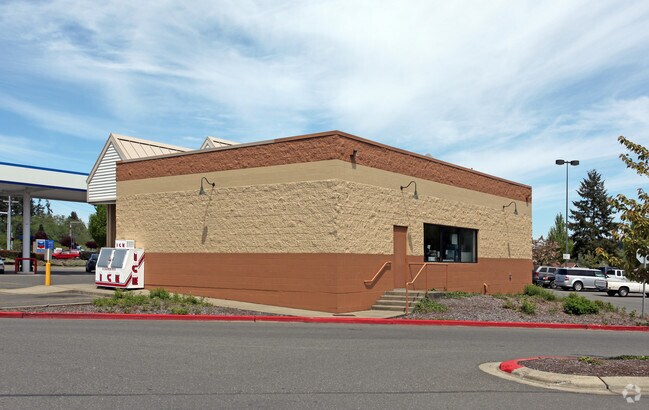
Property Record
390 Sw Sedgwick Rd, Port Orchard, WA 98367

NEARBY LISTINGS FOR SALE OR LEASE
Property Detail
390 Sw Sedgwick Rd
Bremerton-Silverdale, WA
Port Orchard
112301-3-050-2008
LOT A, CITY OF PORT ORCHARD SHORT PLAT NO. PO-143 (S-1157), RECORDED UNDER AUDITORS FILE NO. 201109130428, IN VOLUME 21 OF SHORT PLATS, PAGE 190, BEING A PORTION OF THE NORTHWEST QUARTER OF THE SOUTHWEST QUARTER, SECTION 11, TOWNSHIP 23 NORTH, RANGE
Servicestation
Kitsap
X
Washington
53053C0050E
a
2025
0.74 AC
2026
South Kitsap County
092101
Bremerton/Silverdale
1,700 SF
DEMOGRAPHICS near 390 Sw Sedgwick Rd
1 Mile
3 Mile
5 Mile
2024 Total Population
2,960
33,485
73,589
2029 Population
3,093
34,056
74,613
Pop Growth 2024-2029
+ 4.49%
+ 1.71%
+ 1.39%
Average Age
42
40
39
2024 Total Households
1,182
12,435
26,518
HH Growth 2024-2029
+ 4.57%
+ 1.73%
+ 1.63%
Median Household Inc
$82,375
$77,763
$77,935
Avg Household Size
2.40
2.60
2.50
2024 Avg HH Vehicles
2.00
2.00
2.00
Median Home Value
$475,914
$421,495
$411,734
Median Year Built
1997
1990
1986
Nearby Places
Map Layers
Map Styles
 Street
 Aerial
- Restaurants
- Banks
- Shops
- Fitness
- Groceries
PUBLIC TRANSPORTATION
AIRPORT
Seattle-Tacoma International
DRIVE
WALK
Distance
Seattle-Tacoma International
64 min
45.6 mi
Freight Ports
Port of Seattle
DRIVE
WALK
Distance
Port of Seattle
74 min
55.9 mi
Nearby Properties
Address
Land Use
TOTAL SIZE
Lot Size
Zoning
Address
Land Use
TOTAL SIZE
Lot Size
Zoning
552 SF
17.39 AC
CITY
Address
Land Use
TOTAL SIZE
Lot Size
Zoning
143,022 SF
11.24 AC
R4
Address
Land Use
TOTAL SIZE
Lot Size
Zoning
127,853 SF
7.41 AC
R4
Address
Land Use
TOTAL SIZE
Lot Size
Zoning
135,371 SF
6.04 AC
R4
Address
Land Use
TOTAL SIZE
Lot Size
Zoning
17,592 SF
11.61 AC
UM
Address
Land Use
TOTAL SIZE
Lot Size
Zoning
25,973 SF
8.20 AC
CC
Address
Land Use
TOTAL SIZE
Lot Size
Zoning
110,994 SF
5.35 AC
R4
Address
Land Use
TOTAL SIZE
Lot Size
Zoning
1,092 SF
5.70 AC
CC
Address
Land Use
TOTAL SIZE
Lot Size
Zoning
125,582 SF
4.02 AC
NC
Address
Land Use
TOTAL SIZE
Lot Size
Zoning
110,778 SF
9.24 AC
CC
Address
Land Use
TOTAL SIZE
Lot Size
Zoning
158,870 SF
14.62 AC
CC
Address
Land Use
TOTAL SIZE
Lot Size
Zoning
185,893 SF
17.89 AC
CC
Address
Land Use
TOTAL SIZE
Lot Size
Zoning
14,660 SF
6.14 AC
UM
Address
Land Use
TOTAL SIZE
Lot Size
Zoning
14,660 SF
6.07 AC
UM
Address
Land Use
TOTAL SIZE
Lot Size
Zoning
62,642 SF
4.91 AC
UM
Address
Land Use
TOTAL SIZE
Lot Size
Zoning
73,200 SF
10.25 AC
RI
Address
Land Use
TOTAL SIZE
Lot Size
Zoning
45,379 SF
6.74 AC
UM
Address
Land Use
TOTAL SIZE
Lot Size
Zoning
138,087 SF
14.24 AC
CC
Address
Land Use
TOTAL SIZE
Lot Size
Zoning
68,708 SF
7.89 AC
PF
Address
Land Use
TOTAL SIZE
Lot Size
Zoning
520 SF
7.79 AC
C
Address
Land Use
TOTAL SIZE
Lot Size
Zoning
39,800 SF
4.69 AC
CC
Address
Land Use
TOTAL SIZE
Lot Size
Zoning
43,318 SF
2.54 AC
R4
Address
Land Use
TOTAL SIZE
Lot Size
Zoning
85,187 SF
4.30 AC
CC
Address
Land Use
TOTAL SIZE
Lot Size
Zoning
75,000 SF
3.61 AC
LI
Address
Land Use
TOTAL SIZE
Lot Size
Zoning
65,956 SF
5.32 AC
CC
Address
Land Use
TOTAL SIZE
Lot Size
Zoning
49,222 SF
3.39 AC
BPMU
Address
Land Use
TOTAL SIZE
Lot Size
Zoning
60,244 SF
8.83 AC
CC
Address
Land Use
TOTAL SIZE
Lot Size
Zoning
29,079 SF
9.95 AC
PF
Address
Land Use
TOTAL SIZE
Lot Size
Zoning
52,180 SF
2.97 AC
CC
Address
Land Use
TOTAL SIZE
Lot Size
Zoning
54,200 SF
2.70 AC
CC
The World's #1 Commercial Real Estate Marketplace
Connect with us
© 2025 CoStar Group
The information above has been obtained from sources believed reliable. While we do not doubt its accuracy we have not verified it and make no guarantee, warranty or representation about it. It is your responsibility to independently confirm its accuracy and completeness. Any projections, opinions, assumptions, or estimates used are for example only and do not represent the current or future performance of the property. The value of this transaction to you depends on tax and other factors which should be evaluated by your tax, financial, and legal advisors. You and your advisors should conduct a careful, independent investigation of the property to determine to your satisfaction the suitability of the property for your needs.