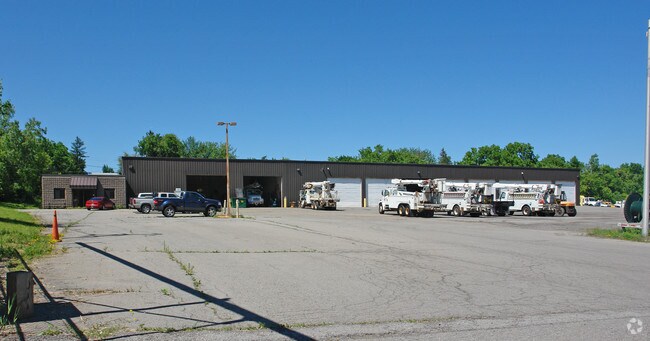
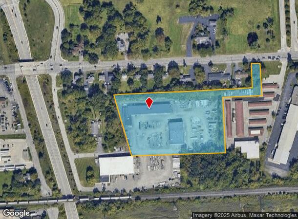
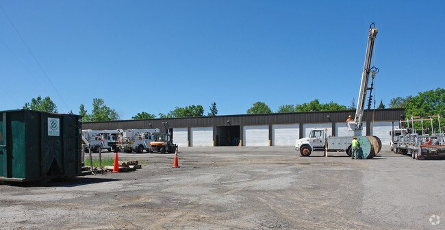
Property Record
390 Systems Rd, Rochester, NY 14623
NEARBY LISTINGS FOR SALE OR LEASE
Property Detail
390 Systems Rd
263200-149-180-0001-021-100
T LOT 3 3RD R 14300 1987 PARCELS B-4 & B-5
Officebuilding
Monroe
X
New York
36055C0351G
21.100
2025
5.42 AC
2024
South Central
013101
Rochester
17,448 SF
Rochester, NY
DEMOGRAPHICS near 390 Systems Rd
1 Mile
3 Mile
5 Mile
2024 Total Population
4,859
55,992
187,690
2029 Population
4,829
55,334
185,206
Pop Growth 2024-2029
(0.62%)
(1.18%)
(1.32%)
Average Age
37
40
39
2024 Total Households
1,901
24,162
81,669
HH Growth 2024-2029
(0.63%)
(1.30%)
(1.36%)
Median Household Inc
$53,880
$62,288
$60,370
Avg Household Size
1.90
2.10
2.10
2024 Avg HH Vehicles
1.00
1.00
1.00
Median Home Value
$158,284
$175,007
$188,758
Median Year Built
1973
1965
1956
Nearby Places
- Restaurants
- Banks
- Shops
- Fitness
- Groceries
PUBLIC TRANSPORTATION
COMMUTER RAIL
Rochester (Empire Service - VIA Rail, Lake Shore Limited - VIA Rail, Maple Leaf - VIA Rail, Toronto - New York - VIA Rail)
DRIVE
WALK
Distance
Rochester (Empire Service - VIA Rail, Lake Shore Limited - VIA Rail, Maple Leaf - VIA Rail, Toronto - New York - VIA Rail)
12 min
5.3 mi
AIRPORT
Frederick Douglass/Greater Rochester International
DRIVE
WALK
Distance
Frederick Douglass/Greater Rochester International
9 min
4.7 mi
Freight Ports
Albany, NY Port
DRIVE
WALK
Distance
Albany, NY Port
267 min
223.9 mi
Nearby Properties
Address
Land Use
TOTAL SIZE
Lot Size
Zoning
Address
Land Use
TOTAL SIZE
Lot Size
Zoning
216,267 SF
112.82 AC
02 - SINGL
Address
Land Use
TOTAL SIZE
Lot Size
Zoning
57,638 SF
227.96 AC
02 - SINGL
Address
Land Use
TOTAL SIZE
Lot Size
Zoning
446,748 SF
14.10 AC
06 - INDUS
Address
Land Use
TOTAL SIZE
Lot Size
Zoning
323,859 SF
19.12 AC
05 - COMME
Address
Land Use
TOTAL SIZE
Lot Size
Zoning
173,649 SF
85.98 AC
Address
Land Use
TOTAL SIZE
Lot Size
Zoning
1,216,095 SF
22.89 AC
Address
Land Use
TOTAL SIZE
Lot Size
Zoning
Address
Land Use
TOTAL SIZE
Lot Size
Zoning
400,000 SF
43.50 AC
06 - INDUS
Address
Land Use
TOTAL SIZE
Lot Size
Zoning
60,120 SF
12.90 AC
Address
Land Use
TOTAL SIZE
Lot Size
Zoning
7,800 SF
166.42 AC
02 - SINGL
Address
Land Use
TOTAL SIZE
Lot Size
Zoning
1,878,160 SF
4.05 AC
Address
Land Use
TOTAL SIZE
Lot Size
Zoning
01 - NOT Z
Address
Land Use
TOTAL SIZE
Lot Size
Zoning
Address
Land Use
TOTAL SIZE
Lot Size
Zoning
614,053 SF
9.30 AC
Address
Land Use
TOTAL SIZE
Lot Size
Zoning
01 - NOT Z
Address
Land Use
TOTAL SIZE
Lot Size
Zoning
330,090 SF
62.41 AC
Address
Land Use
TOTAL SIZE
Lot Size
Zoning
01 - NOT Z
Address
Land Use
TOTAL SIZE
Lot Size
Zoning
0.01 AC
Address
Land Use
TOTAL SIZE
Lot Size
Zoning
6,056 SF
37.65 AC
Address
Land Use
TOTAL SIZE
Lot Size
Zoning
37,632 SF
29.06 AC
06 - INDUS
Address
Land Use
TOTAL SIZE
Lot Size
Zoning
01 - NOT Z
Address
Land Use
TOTAL SIZE
Lot Size
Zoning
128,539 SF
15.01 AC
Address
Land Use
TOTAL SIZE
Lot Size
Zoning
Address
Land Use
TOTAL SIZE
Lot Size
Zoning
3.09 AC
02 - SINGL
Address
Land Use
TOTAL SIZE
Lot Size
Zoning
01 - NOT Z
Address
Land Use
TOTAL SIZE
Lot Size
Zoning
01 - NOT Z
Address
Land Use
TOTAL SIZE
Lot Size
Zoning
Address
Land Use
TOTAL SIZE
Lot Size
Zoning
241,650 SF
23.77 AC
Address
Land Use
TOTAL SIZE
Lot Size
Zoning
06 - INDUS
Address
Land Use
TOTAL SIZE
Lot Size
Zoning
94,000 SF
15.49 AC
02 - SINGL
The World's #1 Commercial Real Estate Marketplace
Connect with us
© 2025 CoStar Group
The information above has been obtained from sources believed reliable. While we do not doubt its accuracy we have not verified it and make no guarantee, warranty or representation about it. It is your responsibility to independently confirm its accuracy and completeness. Any projections, opinions, assumptions, or estimates used are for example only and do not represent the current or future performance of the property. The value of this transaction to you depends on tax and other factors which should be evaluated by your tax, financial, and legal advisors. You and your advisors should conduct a careful, independent investigation of the property to determine to your satisfaction the suitability of the property for your needs.