Property Record
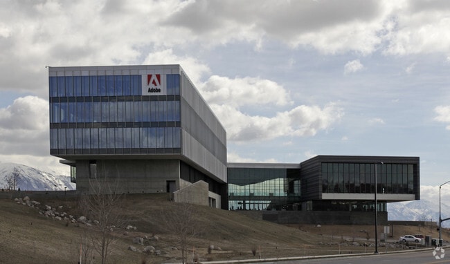
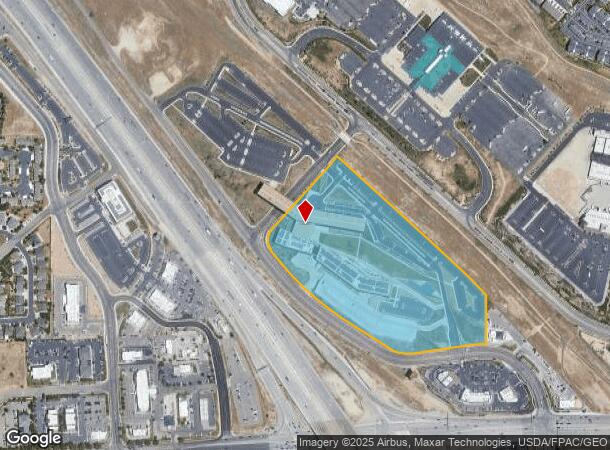
3900 N Adobe Way, Lehi, UT 84043
NEARBY LISTINGS FOR SALE OR LEASE
Property Detail
3900 N Adobe Way
Salt Lake City
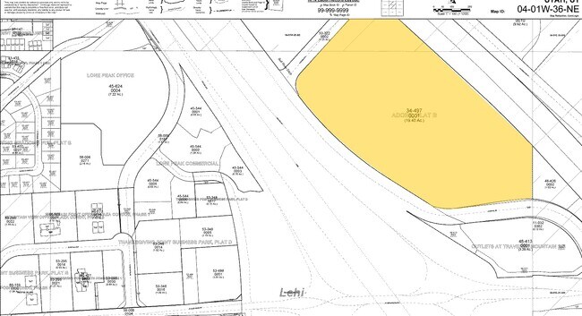
Adobe Sub
Provo-Orem, UT
LOT 1, PLAT B, ADOBE SUB AREA 19.457 AC.
34-497-0001
Utah
Officebuilding
Utah
2024
1
2025
19.46 AC
010212
Utah County
705,130 SF
DEMOGRAPHICS near 3900 N Adobe Way
1 Mile
3 Mile
5 Mile
2024 Total Population
11,527
62,496
159,532
2029 Population
13,825
74,069
182,665
Pop Growth 2024-2029
+ 19.94%
+ 18.52%
+ 14.50%
Average Age
28
29
31
2024 Total Households
3,323
17,287
43,637
HH Growth 2024-2029
+ 20.28%
+ 18.89%
+ 14.73%
Median Household Inc
$109,913
$121,884
$117,770
Avg Household Size
3.40
3.60
3.60
2024 Avg HH Vehicles
2.00
2.00
2.00
Median Home Value
$504,360
$537,595
$586,962
Median Year Built
2010
2010
2009
Nearby Places
Map Layers
Map Styles
 Street
 Aerial
- Restaurants
- Banks
- Shops
- Fitness
- Groceries
PUBLIC TRANSPORTATION
COMMUTER RAIL
Lehi Station (FrontRunner - Utah Transit Authority (UTA))
DRIVE
WALK
Distance
Lehi Station (FrontRunner - Utah Transit Authority (UTA))
5 min
1.8 mi
American Fork Station (FrontRunner - Utah Transit Authority (UTA))
DRIVE
WALK
Distance
American Fork Station (FrontRunner - Utah Transit Authority (UTA))
15 min
7.2 mi
AIRPORT
Provo Municipal
DRIVE
WALK
Distance
Provo Municipal
33 min
22.5 mi
Salt Lake City International
DRIVE
WALK
Distance
Salt Lake City International
36 min
29.9 mi
Freight Ports
Port of Stockton
DRIVE
WALK
Distance
Port of Stockton
737 min
720.2 mi
Nearby Properties
Address
Land Use
TOTAL SIZE
Lot Size
Zoning
Address
Land Use
TOTAL SIZE
Lot Size
Zoning
264,805 SF
16.20 AC
Address
Land Use
TOTAL SIZE
Lot Size
Zoning
81,925 SF
10.13 AC
MU
Address
Land Use
TOTAL SIZE
Lot Size
Zoning
130,480 SF
27.19 AC
Address
Land Use
TOTAL SIZE
Lot Size
Zoning
36.17 AC
Address
Land Use
TOTAL SIZE
Lot Size
Zoning
313,847 SF
35.44 AC
Address
Land Use
TOTAL SIZE
Lot Size
Zoning
130,480 SF
25.12 AC
Address
Land Use
TOTAL SIZE
Lot Size
Zoning
376,499 SF
5.22 AC
Address
Land Use
TOTAL SIZE
Lot Size
Zoning
330,039 SF
10.08 AC
Address
Land Use
TOTAL SIZE
Lot Size
Zoning
386,065 SF
26.62 AC
Address
Land Use
TOTAL SIZE
Lot Size
Zoning
301,411 SF
13.27 AC
Address
Land Use
TOTAL SIZE
Lot Size
Zoning
166,233 SF
8.70 AC
Address
Land Use
TOTAL SIZE
Lot Size
Zoning
118,569 SF
23.63 AC
Address
Land Use
TOTAL SIZE
Lot Size
Zoning
53,777 SF
229.36 AC
SF-1
Address
Land Use
TOTAL SIZE
Lot Size
Zoning
374,937 SF
18.37 AC
Address
Land Use
TOTAL SIZE
Lot Size
Zoning
193.06 AC
1115
Address
Land Use
TOTAL SIZE
Lot Size
Zoning
545,572 SF
182.84 AC
Address
Land Use
TOTAL SIZE
Lot Size
Zoning
281,215 SF
15.30 AC
Address
Land Use
TOTAL SIZE
Lot Size
Zoning
186,256 SF
4.19 AC
Address
Land Use
TOTAL SIZE
Lot Size
Zoning
131,961 SF
7.57 AC
Address
Land Use
TOTAL SIZE
Lot Size
Zoning
247,594 SF
19.01 AC
Address
Land Use
TOTAL SIZE
Lot Size
Zoning
194,033 SF
7.76 AC
Address
Land Use
TOTAL SIZE
Lot Size
Zoning
214,607 SF
7.31 AC
Address
Land Use
TOTAL SIZE
Lot Size
Zoning
194,767 SF
7.35 AC
Address
Land Use
TOTAL SIZE
Lot Size
Zoning
216,478 SF
7.38 AC
Address
Land Use
TOTAL SIZE
Lot Size
Zoning
255,672 SF
6.21 AC
Address
Land Use
TOTAL SIZE
Lot Size
Zoning
206,456 SF
6.55 AC
Address
Land Use
TOTAL SIZE
Lot Size
Zoning
215,516 SF
4.93 AC
Address
Land Use
TOTAL SIZE
Lot Size
Zoning
153,475 SF
3.37 AC
Address
Land Use
TOTAL SIZE
Lot Size
Zoning
181,908 SF
1.43 AC
The World's #1 Commercial Real Estate Marketplace
Connect with us
© 2025 CoStar Group
The information above has been obtained from sources believed reliable. While we do not doubt its accuracy we have not verified it and make no guarantee, warranty or representation about it. It is your responsibility to independently confirm its accuracy and completeness. Any projections, opinions, assumptions, or estimates used are for example only and do not represent the current or future performance of the property. The value of this transaction to you depends on tax and other factors which should be evaluated by your tax, financial, and legal advisors. You and your advisors should conduct a careful, independent investigation of the property to determine to your satisfaction the suitability of the property for your needs.