Property Record
3900 Pascal Ave, Curtis Bay, MD 21226
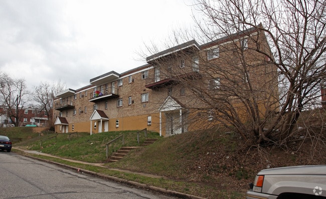

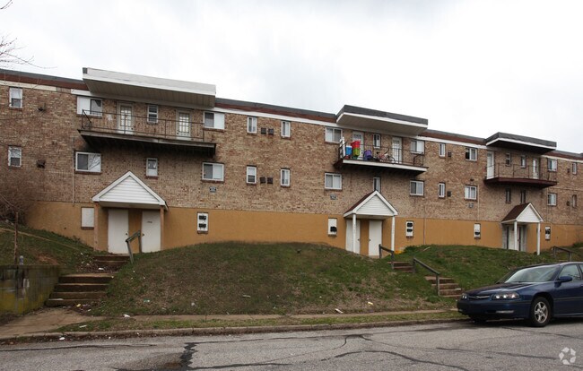
Property Detail
3900 Pascal Ave
Baltimore-Columbia-Towson, MD
0.364 ACRES
7257-132
Baltimore City
Apartment
Maryland
R-6
132
B and X Area of moderate flood hazard, usually the area between the limits of the 100-year and 500-year floods.
0.36 AC
2024
Curtis Bay
2025
Baltimore
250500
NEARBY LISTINGS FOR SALE OR LEASE
DEMOGRAPHICS near 3900 Pascal Ave
1 mile
3 mile
5 mile
2025 Total Population
14,531
57,980
271,243
2030 Population
14,439
57,807
270,879
Pop Growth 2025-2030
(0.63%)
(0.30%)
(0.13%)
Average Age
36
37
37
2025 Total Households
5,134
22,011
114,145
HH Growth 2025-2030
(0.68%)
(0.53%)
(0.28%)
Median Household Inc
$43,799
$67,687
$73,598
Avg Household Size
2.70
2.50
2.30
2025 Avg HH Vehicles
1.00
1.00
1.00
Median Home Value
$186,731
$261,755
$302,558
Median Year Built
1949
1957
1954
Nearby Places
Map Layers
Map Styles
 Street
 Aerial
Layers
 Traffic
 Biking
Places
Listings with unknown addresses are not visible on the map
- Restaurants
- Banks
- Shops
- Fitness
- Groceries
PUBLIC TRANSPORTATION
COMMUTER RAIL
Drive
Walk
Distance
14 min
5.4 mi
Drive
Walk
Distance
18 min
7.6 mi
AIRPORT
Baltimore/Washington International Thurgood Marshall
Drive
Walk
Distance
Baltimore/Washington International Thurgood Marshall
20 min
10.3 mi
Ronald Reagan Washington Ntl
Drive
Walk
Distance
Ronald Reagan Washington Ntl
67 min
42.7 mi
Freight Ports
Port of Baltimore
Drive
Walk
Distance
Port of Baltimore
14 min
5.6 mi
Nearby Properties
Address
Land Use
TOTAL SIZE
Lot Size
Zoning
Address
Land Use
TOTAL SIZE
Lot Size
Zoning
467.03 AC
W2
Address
Land Use
TOTAL SIZE
Lot Size
Zoning
642,817 SF
1.91 AC
PC-2
Address
Land Use
TOTAL SIZE
Lot Size
Zoning
520,407 SF
16.85 AC
H
Address
Land Use
TOTAL SIZE
Lot Size
Zoning
309,558 SF
3.01 AC
C-2
Address
Land Use
TOTAL SIZE
Lot Size
Zoning
315,605 SF
1.80 AC
Address
Land Use
TOTAL SIZE
Lot Size
Zoning
289,829 SF
24.56 AC
C3
Address
Land Use
TOTAL SIZE
Lot Size
Zoning
234,439 SF
1.02 AC
Address
Land Use
TOTAL SIZE
Lot Size
Zoning
290,000 SF
1.51 AC
PC-2
Address
Land Use
TOTAL SIZE
Lot Size
Zoning
19.20 AC
R15
Address
Land Use
TOTAL SIZE
Lot Size
Zoning
12.90 AC
R15
Address
Land Use
TOTAL SIZE
Lot Size
Zoning
233,408 SF
24.73 AC
C3
Address
Land Use
TOTAL SIZE
Lot Size
Zoning
132,655 SF
0.74 AC
Address
Land Use
TOTAL SIZE
Lot Size
Zoning
263,024 SF
6.87 AC
C3
Address
Land Use
TOTAL SIZE
Lot Size
Zoning
18.86 AC
DR16
Address
Land Use
TOTAL SIZE
Lot Size
Zoning
111.20 AC
W3
Address
Land Use
TOTAL SIZE
Lot Size
Zoning
173,735 SF
17.31 AC
PC-4
Address
Land Use
TOTAL SIZE
Lot Size
Zoning
552,387 SF
88.86 AC
MI
Address
Land Use
TOTAL SIZE
Lot Size
Zoning
374,715 SF
2.96 AC
C-2
Address
Land Use
TOTAL SIZE
Lot Size
Zoning
16.26 AC
R15
Address
Land Use
TOTAL SIZE
Lot Size
Zoning
239,476 SF
19.02 AC
MI
Address
Land Use
TOTAL SIZE
Lot Size
Zoning
12 AC
C3
Address
Land Use
TOTAL SIZE
Lot Size
Zoning
190,650 SF
20.80 AC
I-2
Address
Land Use
TOTAL SIZE
Lot Size
Zoning
393,126 SF
2.18 AC
OR-2
Address
Land Use
TOTAL SIZE
Lot Size
Zoning
119,220 SF
6.99 AC
W1
Address
Land Use
TOTAL SIZE
Lot Size
Zoning
227,704 SF
23.52 AC
C4
Address
Land Use
TOTAL SIZE
Lot Size
Zoning
265,423 SF
22.26 AC
MI
Address
Land Use
TOTAL SIZE
Lot Size
Zoning
945,677 SF
18.74 AC
MI
Address
Land Use
TOTAL SIZE
Lot Size
Zoning
518,536 SF
136.14 AC
MI
Address
Land Use
TOTAL SIZE
Lot Size
Zoning
209,044 SF
17.28 AC
C3
Address
Land Use
TOTAL SIZE
Lot Size
Zoning
299,200 SF
2.43 AC
R-8
The World's #1 Commercial Real Estate Marketplace
Connect with us
© 2026 CoStar Group
The information above has been obtained from sources believed reliable. While we do not doubt its accuracy we have not verified it and make no guarantee, warranty or representation about it. It is your responsibility to independently confirm its accuracy and completeness. Any projections, opinions, assumptions, or estimates used are for example only and do not represent the current or future performance of the property. The value of this transaction to you depends on tax and other factors which should be evaluated by your tax, financial, and legal advisors. You and your advisors should conduct a careful, independent investigation of the property to determine to your satisfaction the suitability of the property for your needs.