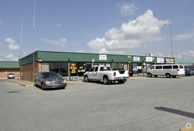
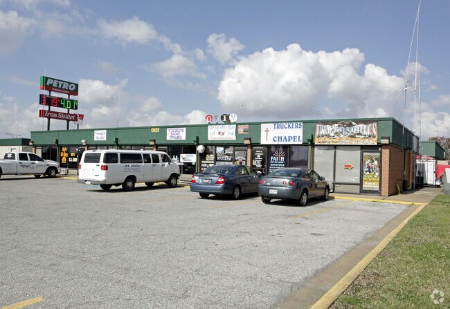
Property Record
3900 Petro Dr, West Memphis, AR 72301

Property Detail
3900 Petro Dr
Memphis, TN-MS-AR
EAST .95 A. OF LOT 2
376-703000-000
Crittenden
Truckstopfuelanddiner
Arkansas
AE The base floodplain where base flood elevations are provided. AE Zones are now used on new format FIRMs instead of A1-A30 Zones.
2
2025
0.94 AC
2025
Crittenden County
030602
Memphis
16,572 SF
NEARBY LISTINGS FOR SALE OR LEASE
DEMOGRAPHICS near 3900 Petro Dr
1 mile
3 mile
5 mile
2025 Total Population
2,390
11,394
43,357
2030 Population
2,411
11,405
42,683
Pop Growth 2025-2030
+ 0.88%
+ 0.10%
(1.55%)
Average Age
33
37
39
2025 Total Households
920
4,412
19,919
HH Growth 2025-2030
+ 0.87%
+ 0.09%
(1.44%)
Median Household Inc
$31,875
$35,816
$58,925
Avg Household Size
2.50
2.50
2.10
2025 Avg HH Vehicles
1.00
1.00
1.00
Median Home Value
$56,521
$79,858
$198,222
Median Year Built
1975
1974
1986
Nearby Places
Map Layers
Map Styles
 Street
 Aerial
Layers
 Traffic
 Biking
Places
Listings with unknown addresses are not visible on the map
- Restaurants
- Banks
- Shops
- Fitness
- Groceries
PUBLIC TRANSPORTATION
COMMUTER RAIL
Central Station (Riverfront Loop - Memphis Area Transit Authority Trolley (MataTrolley))
Drive
Walk
Distance
Central Station (Riverfront Loop - Memphis Area Transit Authority Trolley (MataTrolley))
9 min
6.0 mi
AIRPORT
Memphis International
Drive
Walk
Distance
Memphis International
22 min
15.2 mi
Freight Ports
Port of Shreveport
Drive
Walk
Distance
Port of Shreveport
391 min
363.1 mi
Nearby Properties
Address
Land Use
TOTAL SIZE
Lot Size
Zoning
Address
Land Use
TOTAL SIZE
Lot Size
Zoning
148,005 SF
134.67 AC
Address
Land Use
TOTAL SIZE
Lot Size
Zoning
69,600 SF
38.09 AC
Address
Land Use
TOTAL SIZE
Lot Size
Zoning
46,927 SF
7.52 AC
Address
Land Use
TOTAL SIZE
Lot Size
Zoning
72,051 SF
1.98 AC
Address
Land Use
TOTAL SIZE
Lot Size
Zoning
70,994 SF
3.06 AC
Address
Land Use
TOTAL SIZE
Lot Size
Zoning
46,035 SF
2.31 AC
Address
Land Use
TOTAL SIZE
Lot Size
Zoning
43,781 SF
1.65 AC
Address
Land Use
TOTAL SIZE
Lot Size
Zoning
43,570 SF
1.80 AC
Address
Land Use
TOTAL SIZE
Lot Size
Zoning
64,791 SF
3.57 AC
Address
Land Use
TOTAL SIZE
Lot Size
Zoning
2,817 SF
7.30 AC
Address
Land Use
TOTAL SIZE
Lot Size
Zoning
23,900 SF
11.23 AC
Address
Land Use
TOTAL SIZE
Lot Size
Zoning
3,456 SF
6.09 AC
Address
Land Use
TOTAL SIZE
Lot Size
Zoning
8,178 SF
6.06 AC
Address
Land Use
TOTAL SIZE
Lot Size
Zoning
8,178 SF
3.99 AC
Address
Land Use
TOTAL SIZE
Lot Size
Zoning
31,630 SF
9.58 AC
Address
Land Use
TOTAL SIZE
Lot Size
Zoning
13,015 SF
11.60 AC
Address
Land Use
TOTAL SIZE
Lot Size
Zoning
67,750 SF
5.24 AC
Address
Land Use
TOTAL SIZE
Lot Size
Zoning
15,748 SF
11.54 AC
Address
Land Use
TOTAL SIZE
Lot Size
Zoning
Address
Land Use
TOTAL SIZE
Lot Size
Zoning
13,595 SF
13.05 AC
Address
Land Use
TOTAL SIZE
Lot Size
Zoning
4,800 SF
23.50 AC
Address
Land Use
TOTAL SIZE
Lot Size
Zoning
10,290 SF
4.57 AC
Address
Land Use
TOTAL SIZE
Lot Size
Zoning
8,321 SF
5.27 AC
Address
Land Use
TOTAL SIZE
Lot Size
Zoning
84,830 SF
19.30 AC
Address
Land Use
TOTAL SIZE
Lot Size
Zoning
24,990 SF
4.36 AC
Address
Land Use
TOTAL SIZE
Lot Size
Zoning
20,169 SF
2.66 AC
Address
Land Use
TOTAL SIZE
Lot Size
Zoning
13,740 SF
2.21 AC
Address
Land Use
TOTAL SIZE
Lot Size
Zoning
4,800 SF
Address
Land Use
TOTAL SIZE
Lot Size
Zoning
12,234 SF
9.38 AC
Address
Land Use
TOTAL SIZE
Lot Size
Zoning
136,686 SF
9.39 AC
The World's #1 Commercial Real Estate Marketplace
Connect with us
© 2026 CoStar Group
The information above has been obtained from sources believed reliable. While we do not doubt its accuracy we have not verified it and make no guarantee, warranty or representation about it. It is your responsibility to independently confirm its accuracy and completeness. Any projections, opinions, assumptions, or estimates used are for example only and do not represent the current or future performance of the property. The value of this transaction to you depends on tax and other factors which should be evaluated by your tax, financial, and legal advisors. You and your advisors should conduct a careful, independent investigation of the property to determine to your satisfaction the suitability of the property for your needs.