Property Record
3900 W Northside Dr, Jackson, MS 39209
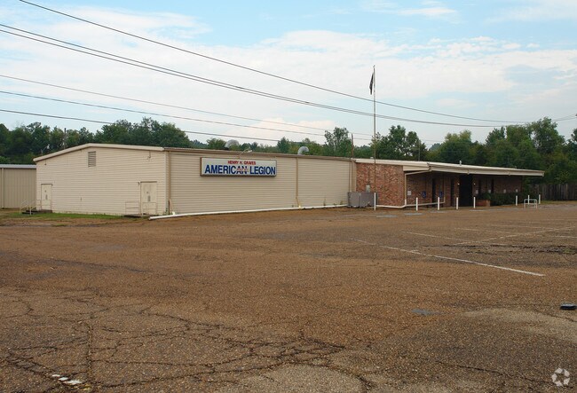

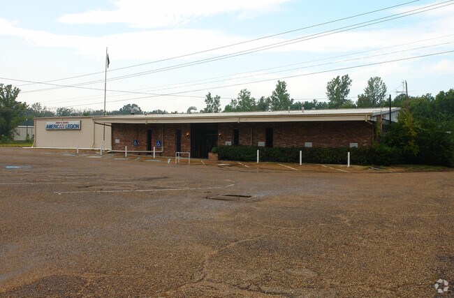
Property Detail
3900 W Northside Dr
0805-0013-000
BEG SE COR SEC 13 T6N R1W W 726 FT TO POB N 660 FT W 367 FT S 660 FT E 366 FT TO POB IN SE 1/4 OF SE 1/4 SEC 13 T6N R1W CONT 5.5 AC LESS 30 FT OFF N/SIDE TO COUNTY FOR ST
Religious
Hinds
B and X Area of moderate flood hazard, usually the area between the limits of the 100-year and 500-year floods.
Mississippi
0
0.50 AC
2025
North Jackson
010301
Jackson
12,604 SF
Jackson, MS
NEARBY LISTINGS FOR SALE OR LEASE
DEMOGRAPHICS near 3900 W Northside Dr
1 mile
3 mile
5 mile
2025 Total Population
1,319
23,746
84,273
2030 Population
1,241
23,073
82,078
Pop Growth 2025-2030
(5.91%)
(2.83%)
(2.60%)
Average Age
44
40
39
2025 Total Households
497
9,779
34,500
HH Growth 2025-2030
(6.04%)
(3.04%)
(2.68%)
Median Household Inc
$43,154
$36,067
$39,895
Avg Household Size
2.40
2.30
2.30
2025 Avg HH Vehicles
2.00
2.00
2.00
Median Home Value
$90,533
$72,854
$101,506
Median Year Built
1974
1968
1968
Nearby Places
Map Layers
Map Styles
 Street
 Aerial
Layers
 Traffic
 Biking
Places
Listings with unknown addresses are not visible on the map
- Restaurants
- Banks
- Shops
- Fitness
- Groceries
PUBLIC TRANSPORTATION
COMMUTER RAIL
Jackson (City of New Orleans - Amtrak)
Drive
Walk
Distance
Jackson (City of New Orleans - Amtrak)
12 min
6.0 mi
AIRPORT
Jackson-Medgar Wiley Evers International
Drive
Walk
Distance
Jackson-Medgar Wiley Evers International
29 min
15.8 mi
Freight Ports
Port of Greater Baton Rouge
Drive
Walk
Distance
Port of Greater Baton Rouge
204 min
181.1 mi
Nearby Properties
Address
Land Use
TOTAL SIZE
Lot Size
Zoning
Address
Land Use
TOTAL SIZE
Lot Size
Zoning
10,100 SF
548 AC
Address
Land Use
TOTAL SIZE
Lot Size
Zoning
16,932 SF
41.60 AC
Address
Land Use
TOTAL SIZE
Lot Size
Zoning
126,628 SF
6.74 AC
Address
Land Use
TOTAL SIZE
Lot Size
Zoning
Address
Land Use
TOTAL SIZE
Lot Size
Zoning
108,979 SF
5 AC
Address
Land Use
TOTAL SIZE
Lot Size
Zoning
132,342 SF
4 AC
Address
Land Use
TOTAL SIZE
Lot Size
Zoning
50,314 SF
115 AC
Address
Land Use
TOTAL SIZE
Lot Size
Zoning
Address
Land Use
TOTAL SIZE
Lot Size
Zoning
40,000 SF
63.11 AC
Address
Land Use
TOTAL SIZE
Lot Size
Zoning
242,035 SF
15.80 AC
Address
Land Use
TOTAL SIZE
Lot Size
Zoning
253,477 SF
23 AC
Address
Land Use
TOTAL SIZE
Lot Size
Zoning
39,928 SF
1 AC
Address
Land Use
TOTAL SIZE
Lot Size
Zoning
582,942 SF
31.22 AC
Address
Land Use
TOTAL SIZE
Lot Size
Zoning
8,610 SF
2 AC
Address
Land Use
TOTAL SIZE
Lot Size
Zoning
108,570 SF
8 AC
Address
Land Use
TOTAL SIZE
Lot Size
Zoning
61,865 SF
4 AC
Address
Land Use
TOTAL SIZE
Lot Size
Zoning
357,468 SF
15 AC
Address
Land Use
TOTAL SIZE
Lot Size
Zoning
1,550 SF
19.71 AC
Address
Land Use
TOTAL SIZE
Lot Size
Zoning
41 AC
Address
Land Use
TOTAL SIZE
Lot Size
Zoning
33,519 SF
5.94 AC
Address
Land Use
TOTAL SIZE
Lot Size
Zoning
4,370 SF
70 AC
Address
Land Use
TOTAL SIZE
Lot Size
Zoning
96,367 SF
6.44 AC
Address
Land Use
TOTAL SIZE
Lot Size
Zoning
11,025 SF
1.41 AC
Address
Land Use
TOTAL SIZE
Lot Size
Zoning
105,000 SF
10.80 AC
Address
Land Use
TOTAL SIZE
Lot Size
Zoning
7,500 SF
129,803.95 AC
Address
Land Use
TOTAL SIZE
Lot Size
Zoning
19,925 SF
13.36 AC
Address
Land Use
TOTAL SIZE
Lot Size
Zoning
Address
Land Use
TOTAL SIZE
Lot Size
Zoning
103,814 SF
8.54 AC
Address
Land Use
TOTAL SIZE
Lot Size
Zoning
Address
Land Use
TOTAL SIZE
Lot Size
Zoning
8,090 SF
6.96 AC
The World's #1 Commercial Real Estate Marketplace
Connect with us
© 2026 CoStar Group
The information above has been obtained from sources believed reliable. While we do not doubt its accuracy we have not verified it and make no guarantee, warranty or representation about it. It is your responsibility to independently confirm its accuracy and completeness. Any projections, opinions, assumptions, or estimates used are for example only and do not represent the current or future performance of the property. The value of this transaction to you depends on tax and other factors which should be evaluated by your tax, financial, and legal advisors. You and your advisors should conduct a careful, independent investigation of the property to determine to your satisfaction the suitability of the property for your needs.