Property Record
3911 W Van Buren St, Phoenix, AZ 85009


Current Lease Availabilities
NEARBY LISTINGS FOR SALE OR LEASE
Property Detail
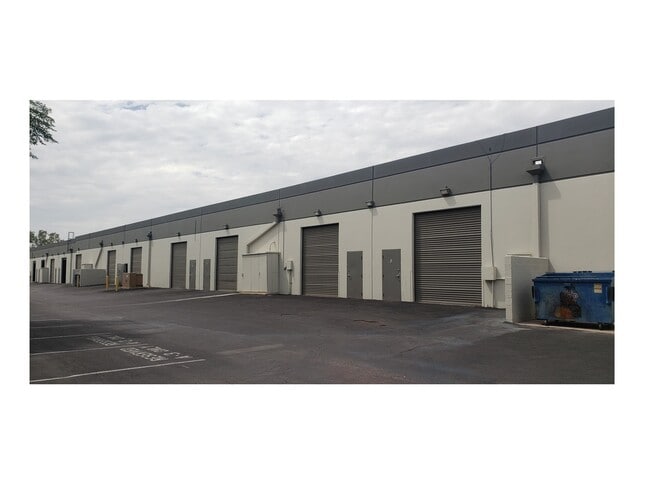
3911 W Van Buren St
Phoenix-Mesa-Scottsdale, AZ
Reywest Industrial Center Unit 1
106-16-015B
REYWEST INDUSTRIAL CENTER UNIT 1 MCR 208-50
Warehouse
Maricopa
X
Arizona
04013C2185L
8
2025
2.64 AC
2025
SW N of Buckeye Road
114600
Phoenix
41,267 SF
DEMOGRAPHICS near 3911 W Van Buren St
1 Mile
3 Mile
5 Mile
2024 Total Population
13,602
95,021
367,755
2029 Population
14,493
101,868
396,987
Pop Growth 2024-2029
+ 6.55%
+ 7.21%
+ 7.95%
Average Age
32
33
33
2024 Total Households
3,757
26,853
114,597
HH Growth 2024-2029
+ 6.60%
+ 7.37%
+ 8.53%
Median Household Inc
$40,853
$46,270
$51,722
Avg Household Size
3.40
3.30
3.00
2024 Avg HH Vehicles
2.00
2.00
2.00
Median Home Value
$117,442
$194,346
$252,803
Median Year Built
1971
1969
1975
Nearby Places
Map Layers
Map Styles
 Street
 Aerial
- Restaurants
- Banks
- Shops
- Fitness
- Groceries
PUBLIC TRANSPORTATION
AIRPORT
Phoenix Sky Harbor International
DRIVE
WALK
Distance
Phoenix Sky Harbor International
18 min
11.0 mi
Phoenix-Mesa Gateway
DRIVE
WALK
Distance
Phoenix-Mesa Gateway
51 min
38.1 mi
Nearby Properties
Address
Land Use
TOTAL SIZE
Lot Size
Zoning
Address
Land Use
TOTAL SIZE
Lot Size
Zoning
569,517 SF
33.38 AC
PUD
Address
Land Use
TOTAL SIZE
Lot Size
Zoning
270,000 SF
12.90 AC
I-1
Address
Land Use
TOTAL SIZE
Lot Size
Zoning
781,334 SF
59.96 AC
I-1
Address
Land Use
TOTAL SIZE
Lot Size
Zoning
182,984 SF
146.12 AC
I-1
Address
Land Use
TOTAL SIZE
Lot Size
Zoning
1,378,775 SF
86.09 AC
M-H
Address
Land Use
TOTAL SIZE
Lot Size
Zoning
91,000 SF
7.57 AC
I-1
Address
Land Use
TOTAL SIZE
Lot Size
Zoning
86,350 SF
25.82 AC
I-1
Address
Land Use
TOTAL SIZE
Lot Size
Zoning
33.15 AC
Address
Land Use
TOTAL SIZE
Lot Size
Zoning
20,430 SF
24.57 AC
I-1
Address
Land Use
TOTAL SIZE
Lot Size
Zoning
440,160 SF
42.43 AC
A1
Address
Land Use
TOTAL SIZE
Lot Size
Zoning
61,508 SF
23.76 AC
I-1
Address
Land Use
TOTAL SIZE
Lot Size
Zoning
69,542 SF
4.92 AC
I-P
Address
Land Use
TOTAL SIZE
Lot Size
Zoning
377,037 SF
35.46 AC
R1-6
Address
Land Use
TOTAL SIZE
Lot Size
Zoning
1,205,743 SF
59.34 AC
I-1
Address
Land Use
TOTAL SIZE
Lot Size
Zoning
1,063,188 SF
59.94 AC
Address
Land Use
TOTAL SIZE
Lot Size
Zoning
416,837 SF
5.35 AC
C-2
Address
Land Use
TOTAL SIZE
Lot Size
Zoning
42,631 SF
2.90 AC
A-2
Address
Land Use
TOTAL SIZE
Lot Size
Zoning
335,897 SF
2.07 AC
R-5
Address
Land Use
TOTAL SIZE
Lot Size
Zoning
550,683 SF
1.98 AC
C-C
Address
Land Use
TOTAL SIZE
Lot Size
Zoning
250,448 SF
3.59 AC
C-3
Address
Land Use
TOTAL SIZE
Lot Size
Zoning
659,834 SF
42.04 AC
R-6
Address
Land Use
TOTAL SIZE
Lot Size
Zoning
14.16 AC
Address
Land Use
TOTAL SIZE
Lot Size
Zoning
449,802 SF
27.08 AC
A-1
Address
Land Use
TOTAL SIZE
Lot Size
Zoning
592,330 SF
36.89 AC
I-2
Address
Land Use
TOTAL SIZE
Lot Size
Zoning
554,011 SF
26.10 AC
I-P
Address
Land Use
TOTAL SIZE
Lot Size
Zoning
489,284 SF
28.64 AC
I-1
Address
Land Use
TOTAL SIZE
Lot Size
Zoning
662,796 SF
42.11 AC
I-1
Address
Land Use
TOTAL SIZE
Lot Size
Zoning
532,713 SF
27.31 AC
Address
Land Use
TOTAL SIZE
Lot Size
Zoning
474,532 SF
26.17 AC
I-1
Address
Land Use
TOTAL SIZE
Lot Size
Zoning
347,565 SF
21.44 AC
A1
The World's #1 Commercial Real Estate Marketplace
Connect with us
© 2025 CoStar Group
The information above has been obtained from sources believed reliable. While we do not doubt its accuracy we have not verified it and make no guarantee, warranty or representation about it. It is your responsibility to independently confirm its accuracy and completeness. Any projections, opinions, assumptions, or estimates used are for example only and do not represent the current or future performance of the property. The value of this transaction to you depends on tax and other factors which should be evaluated by your tax, financial, and legal advisors. You and your advisors should conduct a careful, independent investigation of the property to determine to your satisfaction the suitability of the property for your needs.