Property Record
3901 Brickit Ct, Ceres, CA 95307


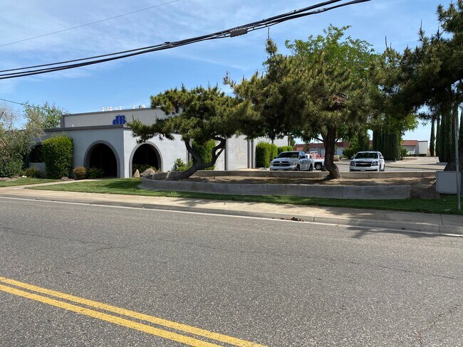

Property Detail
3901 Brickit Ct
Modesto, CA
PCL 1 27 PM 112
053-13-11
Stanislaus
Warehouse
California
B and X Area of moderate flood hazard, usually the area between the limits of the 100-year and 500-year floods.
1
2025
1.04 AC
2025
Ceres
002602
Stockton/Modesto
6,372 SF
NEARBY LISTINGS FOR SALE OR LEASE
DEMOGRAPHICS near 3901 Brickit Ct
1 mile
3 mile
5 mile
2025 Total Population
9,676
62,757
140,187
2030 Population
9,757
63,147
140,733
Pop Growth 2025-2030
+ 0.84%
+ 0.62%
+ 0.39%
Average Age
35
35
35
2025 Total Households
2,853
17,479
39,829
HH Growth 2025-2030
+ 0.88%
+ 0.65%
+ 0.37%
Median Household Inc
$69,342
$80,869
$74,517
Avg Household Size
3.40
3.50
3.40
2025 Avg HH Vehicles
2.00
2.00
2.00
Median Home Value
$412,917
$441,519
$417,996
Median Year Built
1976
1983
1978
Nearby Places
Map Layers
Map Styles
 Street
 Aerial
Transit
 Traffic
 Biking
Places
Listings with unknown addresses are not visible on the map
- Restaurants
- Banks
- Shops
- Fitness
- Groceries
PUBLIC TRANSPORTATION
AIRPORT
Stockton Metro
Drive
Walk
Distance
Stockton Metro
40 min
30.0 mi
Freight Ports
Port of Stockton
Drive
Walk
Distance
Port of Stockton
48 min
38.5 mi
SALE & LEASE HISTORY
LISTING DATE
SALE/LEASE

Sep 02, 2020
For Lease
Jul 15, 2021
For Lease
Jul 01, 2020
For Sale
Nearby Properties
Address
Land Use
TOTAL SIZE
Lot Size
Zoning
Address
Land Use
TOTAL SIZE
Lot Size
Zoning
877,788 SF
103.22 AC
MI
Address
Land Use
TOTAL SIZE
Lot Size
Zoning
726,299 SF
38.86 AC
M2
Address
Land Use
TOTAL SIZE
Lot Size
Zoning
774,633 SF
39.18 AC
MODM2
Address
Land Use
TOTAL SIZE
Lot Size
Zoning
1,897,790 SF
92.04 AC
M2
Address
Land Use
TOTAL SIZE
Lot Size
Zoning
697,000 SF
37.82 AC
MODM2
Address
Land Use
TOTAL SIZE
Lot Size
Zoning
194,384 SF
17.34 AC
MODM2
Address
Land Use
TOTAL SIZE
Lot Size
Zoning
21,802 SF
10.96 AC
COUM
Address
Land Use
TOTAL SIZE
Lot Size
Zoning
186,058 SF
14.35 AC
CERRC
Address
Land Use
TOTAL SIZE
Lot Size
Zoning
204,801 SF
12.99 AC
M2
Address
Land Use
TOTAL SIZE
Lot Size
Zoning
326,176 SF
14.92 AC
MODM2
Address
Land Use
TOTAL SIZE
Lot Size
Zoning
255,404 SF
17.49 AC
Address
Land Use
TOTAL SIZE
Lot Size
Zoning
71,572 SF
5.35 AC
Address
Land Use
TOTAL SIZE
Lot Size
Zoning
362,384 SF
19.43 AC
Address
Land Use
TOTAL SIZE
Lot Size
Zoning
61,640 SF
5.39 AC
Address
Land Use
TOTAL SIZE
Lot Size
Zoning
174,524 SF
11.61 AC
M
Address
Land Use
TOTAL SIZE
Lot Size
Zoning
63,527 SF
5.18 AC
MI
Address
Land Use
TOTAL SIZE
Lot Size
Zoning
172,380 SF
11.92 AC
M2
Address
Land Use
TOTAL SIZE
Lot Size
Zoning
102,489 SF
10.27 AC
C2
Address
Land Use
TOTAL SIZE
Lot Size
Zoning
75,262 SF
2.31 AC
C1
Address
Land Use
TOTAL SIZE
Lot Size
Zoning
217,998 SF
15.02 AC
Address
Land Use
TOTAL SIZE
Lot Size
Zoning
325,000 SF
14.26 AC
Address
Land Use
TOTAL SIZE
Lot Size
Zoning
57,395 SF
3.43 AC
CERIP
Address
Land Use
TOTAL SIZE
Lot Size
Zoning
88,283 SF
11.48 AC
Address
Land Use
TOTAL SIZE
Lot Size
Zoning
62,761 SF
5.27 AC
Address
Land Use
TOTAL SIZE
Lot Size
Zoning
87,361 SF
3.84 AC
CERPC
Address
Land Use
TOTAL SIZE
Lot Size
Zoning
66,169 SF
4.06 AC
Address
Land Use
TOTAL SIZE
Lot Size
Zoning
98,100 SF
5.65 AC
Address
Land Use
TOTAL SIZE
Lot Size
Zoning
2.14 AC
CERRC
Address
Land Use
TOTAL SIZE
Lot Size
Zoning
64,747 SF
3.85 AC
Address
Land Use
TOTAL SIZE
Lot Size
Zoning
41,223 SF
18.03 AC
CERPC
The World's #1 Commercial Real Estate Marketplace
Connect with us
© 2026 CoStar Group
The information above has been obtained from sources believed reliable. While we do not doubt its accuracy we have not verified it and make no guarantee, warranty or representation about it. It is your responsibility to independently confirm its accuracy and completeness. Any projections, opinions, assumptions, or estimates used are for example only and do not represent the current or future performance of the property. The value of this transaction to you depends on tax and other factors which should be evaluated by your tax, financial, and legal advisors. You and your advisors should conduct a careful, independent investigation of the property to determine to your satisfaction the suitability of the property for your needs.