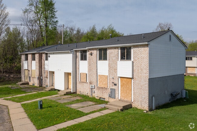
Property Record
3901 Burneway Dr, Lansing, MI 48911


Save to a Folder
{{folder.Name}}
{{folder.ListingIds.length}} Properties
{{folder.ListingIds.length}} Property
Create a New Folder
Property Detail
3901 Burneway Dr
235-040-364-760-01
LOT 225 GLENBURNE NO 4, CITY OF LANSING
Commercialnec
Eaton
DM-1 RE
Michigan
B and X Area of moderate flood hazard, usually the area between the limits of the 100-year and 500-year floods.
225
2025
9.57 AC
2026
Southern Lansing
020202
West Michigan
62,100 SF
Lansing-East Lansing, MI
NEARBY LISTINGS FOR SALE OR LEASE
DEMOGRAPHICS near 3901 Burneway Dr
1 mile
3 mile
5 mile
2025 Total Population
10,218
50,269
130,851
2030 Population
10,245
50,478
132,410
Pop Growth 2025-2030
+ 0.26%
+ 0.42%
+ 1.19%
Average Age
36
39
39
2025 Total Households
3,907
20,924
57,314
HH Growth 2025-2030
+ 0.08%
+ 0.40%
+ 1.27%
Median Household Inc
$53,407
$58,764
$58,289
Avg Household Size
2.50
2.30
2.20
2025 Avg HH Vehicles
2.00
2.00
2.00
Median Home Value
$139,337
$151,969
$162,316
Median Year Built
1970
1966
1966
Nearby Places
Map Layers
Map Styles
 Street
 Aerial
Layers
 Traffic
 Biking
Places
Listings with unknown addresses are not visible on the map
- Restaurants
- Banks
- Shops
- Fitness
- Groceries
PUBLIC TRANSPORTATION
COMMUTER RAIL
East Lansing Amtrak Station (Blue Water - Amtrak)
Drive
Walk
Distance
East Lansing Amtrak Station (Blue Water - Amtrak)
14 min
8.3 mi
AIRPORT
Capital Region International
Drive
Walk
Distance
Capital Region International
15 min
7.2 mi
Freight Ports
Port of Toledo
Drive
Walk
Distance
Port of Toledo
149 min
126.1 mi
Nearby Properties
Address
Land Use
TOTAL SIZE
Lot Size
Zoning
Address
Land Use
TOTAL SIZE
Lot Size
Zoning
1,085,633 SF
115.14 AC
NONE
Address
Land Use
TOTAL SIZE
Lot Size
Zoning
628,230 SF
38.20 AC
NONE
Address
Land Use
TOTAL SIZE
Lot Size
Zoning
286.23 AC
NONE
Address
Land Use
TOTAL SIZE
Lot Size
Zoning
1,059,295 SF
139.28 AC
NONE
Address
Land Use
TOTAL SIZE
Lot Size
Zoning
389,485 SF
30.04 AC
NONE
Address
Land Use
TOTAL SIZE
Lot Size
Zoning
217,664 SF
61.37 AC
NONE
Address
Land Use
TOTAL SIZE
Lot Size
Zoning
198,225 SF
11.54 AC
NONE
Address
Land Use
TOTAL SIZE
Lot Size
Zoning
2,276,790 SF
96.93 AC
NONE
Address
Land Use
TOTAL SIZE
Lot Size
Zoning
628,651 SF
34.29 AC
NONE
Address
Land Use
TOTAL SIZE
Lot Size
Zoning
292,918 SF
I-FAC
Address
Land Use
TOTAL SIZE
Lot Size
Zoning
111,804 SF
80 AC
NONE
Address
Land Use
TOTAL SIZE
Lot Size
Zoning
824,570 SF
47.65 AC
NONE
Address
Land Use
TOTAL SIZE
Lot Size
Zoning
219,176 SF
9.45 AC
NONE
Address
Land Use
TOTAL SIZE
Lot Size
Zoning
50,364 SF
25.57 AC
M-1
Address
Land Use
TOTAL SIZE
Lot Size
Zoning
144,630 SF
11.51 AC
M-1
Address
Land Use
TOTAL SIZE
Lot Size
Zoning
14,505 SF
90 AC
Address
Land Use
TOTAL SIZE
Lot Size
Zoning
269,800 SF
20.10 AC
NONE
Address
Land Use
TOTAL SIZE
Lot Size
Zoning
14.78 AC
F COMM
Address
Land Use
TOTAL SIZE
Lot Size
Zoning
250,100 SF
25.45 AC
NONE
Address
Land Use
TOTAL SIZE
Lot Size
Zoning
404,215 SF
40 AC
NONE
Address
Land Use
TOTAL SIZE
Lot Size
Zoning
4,602 SF
144.53 AC
Address
Land Use
TOTAL SIZE
Lot Size
Zoning
53,147 SF
15.70 AC
C
Address
Land Use
TOTAL SIZE
Lot Size
Zoning
161,686 SF
220 AC
D-1 PRO
Address
Land Use
TOTAL SIZE
Lot Size
Zoning
8,469 SF
160 AC
Address
Land Use
TOTAL SIZE
Lot Size
Zoning
166,296 SF
39.72 AC
NONE
Address
Land Use
TOTAL SIZE
Lot Size
Zoning
45,486 SF
15.93 AC
H LT IN
Address
Land Use
TOTAL SIZE
Lot Size
Zoning
53,147 SF
16.49 AC
NONE
Address
Land Use
TOTAL SIZE
Lot Size
Zoning
441,242 SF
41.27 AC
NONE
Address
Land Use
TOTAL SIZE
Lot Size
Zoning
1,496 SF
47.39 AC
RM-1
Address
Land Use
TOTAL SIZE
Lot Size
Zoning
3,006 SF
136 AC
DM-1 RE
The World's #1 Commercial Real Estate Marketplace
Connect with us
© 2026 CoStar Group
The information above has been obtained from sources believed reliable. While we do not doubt its accuracy we have not verified it and make no guarantee, warranty or representation about it. It is your responsibility to independently confirm its accuracy and completeness. Any projections, opinions, assumptions, or estimates used are for example only and do not represent the current or future performance of the property. The value of this transaction to you depends on tax and other factors which should be evaluated by your tax, financial, and legal advisors. You and your advisors should conduct a careful, independent investigation of the property to determine to your satisfaction the suitability of the property for your needs.