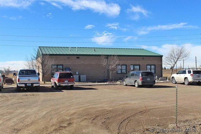
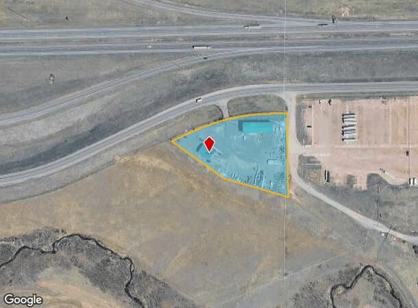
Property Record
3901 S Industrial Rd, Cheyenne, WY 82007

NEARBY LISTINGS FOR SALE OR LEASE
Property Detail
3901 S Industrial Rd
Cheyenne, WY
Strid
1-8452-0001-0001-0
STRID ADDITION: LOT 1, BLOCK 1
Commercialnec
Laramie
X
Wyoming
08123C0025E
1
2024
2.65 AC
2025
I-80 Corridor/Cheyenne
000403
Other Market Areas
7,990 SF
DEMOGRAPHICS near 3901 S Industrial Rd
1 Mile
3 Mile
5 Mile
2024 Total Population
3,300
45,908
74,607
2029 Population
3,345
46,784
76,030
Pop Growth 2024-2029
+ 1.36%
+ 1.91%
+ 1.91%
Average Age
38
38
39
2024 Total Households
1,220
19,579
31,933
HH Growth 2024-2029
+ 1.48%
+ 2.03%
+ 2.01%
Median Household Inc
$64,371
$54,173
$58,307
Avg Household Size
2.60
2.30
2.30
2024 Avg HH Vehicles
3.00
2.00
2.00
Median Home Value
$235,413
$241,896
$264,493
Median Year Built
1966
1976
1976
Nearby Places
Map Layers
Map Styles
 Street
 Aerial
- Restaurants
- Banks
- Shops
- Fitness
- Groceries
SALE & LEASE HISTORY
LISTING DATE
SALE/LEASE

Sep 23, 2016
For Sale
Oct 06, 2021
For Lease
Nov 02, 2020
For Sale
Jan 18, 2018
For Sale
Apr 28, 2022
For Lease
Nearby Properties
Address
Land Use
TOTAL SIZE
Lot Size
Zoning
Address
Land Use
TOTAL SIZE
Lot Size
Zoning
240.51 AC
A2
Address
Land Use
TOTAL SIZE
Lot Size
Zoning
639,397 SF
67.52 AC
Address
Land Use
TOTAL SIZE
Lot Size
Zoning
Address
Land Use
TOTAL SIZE
Lot Size
Zoning
243,960 SF
60.52 AC
Address
Land Use
TOTAL SIZE
Lot Size
Zoning
91,021 SF
7.40 AC
Address
Land Use
TOTAL SIZE
Lot Size
Zoning
189,952 SF
11.15 AC
HR2
Address
Land Use
TOTAL SIZE
Lot Size
Zoning
Address
Land Use
TOTAL SIZE
Lot Size
Zoning
210,717 SF
18.28 AC
Address
Land Use
TOTAL SIZE
Lot Size
Zoning
180,600 SF
13.72 AC
HI
Address
Land Use
TOTAL SIZE
Lot Size
Zoning
136,488 SF
13.38 AC
CB
Address
Land Use
TOTAL SIZE
Lot Size
Zoning
114,342 SF
59.95 AC
HI
Address
Land Use
TOTAL SIZE
Lot Size
Zoning
135,427 SF
6.61 AC
Address
Land Use
TOTAL SIZE
Lot Size
Zoning
109,096 SF
4.03 AC
MR2
Address
Land Use
TOTAL SIZE
Lot Size
Zoning
193,881 SF
21.36 AC
CB
Address
Land Use
TOTAL SIZE
Lot Size
Zoning
109,744 SF
7.04 AC
Address
Land Use
TOTAL SIZE
Lot Size
Zoning
81,948 SF
9.39 AC
CB
Address
Land Use
TOTAL SIZE
Lot Size
Zoning
37,714 SF
4.29 AC
Address
Land Use
TOTAL SIZE
Lot Size
Zoning
108,716 SF
12.45 AC
Address
Land Use
TOTAL SIZE
Lot Size
Zoning
69,941 SF
4.31 AC
LI
Address
Land Use
TOTAL SIZE
Lot Size
Zoning
88,107 SF
10.73 AC
Address
Land Use
TOTAL SIZE
Lot Size
Zoning
59,325 SF
0.85 AC
CBD
Address
Land Use
TOTAL SIZE
Lot Size
Zoning
96,088 SF
8.34 AC
Address
Land Use
TOTAL SIZE
Lot Size
Zoning
69,103 SF
17.34 AC
Address
Land Use
TOTAL SIZE
Lot Size
Zoning
73,266 SF
8.08 AC
Address
Land Use
TOTAL SIZE
Lot Size
Zoning
59,223 SF
9.91 AC
HI
Address
Land Use
TOTAL SIZE
Lot Size
Zoning
71,841 SF
8.11 AC
Address
Land Use
TOTAL SIZE
Lot Size
Zoning
55,750 SF
1.58 AC
Address
Land Use
TOTAL SIZE
Lot Size
Zoning
54,666 SF
3.69 AC
MR2
Address
Land Use
TOTAL SIZE
Lot Size
Zoning
135,125 SF
8.87 AC
Address
Land Use
TOTAL SIZE
Lot Size
Zoning
174,000 SF
11.57 AC
MR2
The World's #1 Commercial Real Estate Marketplace
Connect with us
© 2025 CoStar Group
The information above has been obtained from sources believed reliable. While we do not doubt its accuracy we have not verified it and make no guarantee, warranty or representation about it. It is your responsibility to independently confirm its accuracy and completeness. Any projections, opinions, assumptions, or estimates used are for example only and do not represent the current or future performance of the property. The value of this transaction to you depends on tax and other factors which should be evaluated by your tax, financial, and legal advisors. You and your advisors should conduct a careful, independent investigation of the property to determine to your satisfaction the suitability of the property for your needs.