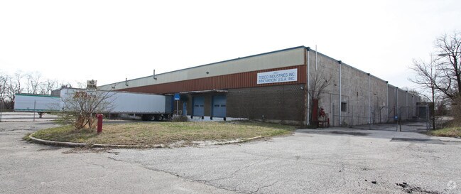
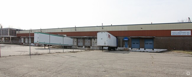
Property Record
3901 Washington Blvd, Halethorpe, MD 21227


Property Detail
3901 Washington Blvd
13-1313203290
7.5481 AC NW COR BALTO CO BELTWAY
Lightindustrial
BALTIMORE
ML-IM
Maryland
B and X Area of moderate flood hazard, usually the area between the limits of the 100-year and 500-year floods.
2
2024
7.55 AC
2025
Arbutus
430400
Baltimore
288,642 SF
Baltimore-Columbia-Towson, MD
NEARBY LISTINGS FOR SALE OR LEASE
DEMOGRAPHICS near 3901 Washington Blvd
1 mile
3 mile
5 mile
2025 Total Population
9,172
91,999
311,049
2030 Population
9,234
91,333
312,061
Pop Growth 2025-2030
+ 0.68%
(0.72%)
+ 0.33%
Average Age
37
38
39
2025 Total Households
3,241
33,820
126,254
HH Growth 2025-2030
+ 0.71%
(0.93%)
+ 0.15%
Median Household Inc
$74,121
$70,183
$67,547
Avg Household Size
2.70
2.50
2.30
2025 Avg HH Vehicles
2.00
2.00
1.00
Median Home Value
$253,216
$274,931
$280,217
Median Year Built
1957
1957
1955
Nearby Places
Map Layers
Map Styles
 Street
 Aerial
Layers
 Traffic
 Biking
Places
Listings with unknown addresses are not visible on the map
- Restaurants
- Banks
- Shops
- Fitness
- Groceries
PUBLIC TRANSPORTATION
COMMUTER RAIL
Drive
Walk
Distance
6 min
2.0 mi
Drive
Walk
Distance
6 min
2.0 mi
AIRPORT
Baltimore/Washington International Thurgood Marshall
Drive
Walk
Distance
Baltimore/Washington International Thurgood Marshall
13 min
6.5 mi
Ronald Reagan Washington Ntl
Drive
Walk
Distance
Ronald Reagan Washington Ntl
60 min
39.2 mi
Freight Ports
Port of Baltimore
Drive
Walk
Distance
Port of Baltimore
13 min
6.5 mi
Nearby Properties
Address
Land Use
TOTAL SIZE
Lot Size
Zoning
Address
Land Use
TOTAL SIZE
Lot Size
Zoning
1,396,807 SF
32.73 AC
R-6
Address
Land Use
TOTAL SIZE
Lot Size
Zoning
2,182,087 SF
95.52 AC
DR5.5
Address
Land Use
TOTAL SIZE
Lot Size
Zoning
430,940 SF
18.81 AC
MXDT
Address
Land Use
TOTAL SIZE
Lot Size
Zoning
305,483 SF
11.38 AC
MXDT
Address
Land Use
TOTAL SIZE
Lot Size
Zoning
332,190 SF
21.80 AC
W1-BW
Address
Land Use
TOTAL SIZE
Lot Size
Zoning
523,800 SF
28.02 AC
I-1
Address
Land Use
TOTAL SIZE
Lot Size
Zoning
315,055 SF
9.60 AC
ML
Address
Land Use
TOTAL SIZE
Lot Size
Zoning
231,128 SF
8.30 AC
W1-BW
Address
Land Use
TOTAL SIZE
Lot Size
Zoning
1,308,804 SF
16.24 AC
I-MU
Address
Land Use
TOTAL SIZE
Lot Size
Zoning
18.86 AC
DR16
Address
Land Use
TOTAL SIZE
Lot Size
Zoning
184,317 SF
16.23 AC
MH
Address
Land Use
TOTAL SIZE
Lot Size
Zoning
41.14 AC
W1-BW
Address
Land Use
TOTAL SIZE
Lot Size
Zoning
40.17 AC
DR16
Address
Land Use
TOTAL SIZE
Lot Size
Zoning
300,513 SF
32.53 AC
I-1
Address
Land Use
TOTAL SIZE
Lot Size
Zoning
15.05 AC
R15
Address
Land Use
TOTAL SIZE
Lot Size
Zoning
48,300 SF
30.96 AC
ML
Address
Land Use
TOTAL SIZE
Lot Size
Zoning
116,600 SF
8.97 AC
C4
Address
Land Use
TOTAL SIZE
Lot Size
Zoning
197,754 SF
12.63 AC
DR5.5
Address
Land Use
TOTAL SIZE
Lot Size
Zoning
101,220 SF
17.51 AC
DR5.5
Address
Land Use
TOTAL SIZE
Lot Size
Zoning
338,255 SF
42.87 AC
W1-BW
Address
Land Use
TOTAL SIZE
Lot Size
Zoning
194,652 SF
20.49 AC
W1-BW
Address
Land Use
TOTAL SIZE
Lot Size
Zoning
19.86 AC
DR16
Address
Land Use
TOTAL SIZE
Lot Size
Zoning
145,226 SF
9.24 AC
W1
Address
Land Use
TOTAL SIZE
Lot Size
Zoning
21.46 AC
ML
Address
Land Use
TOTAL SIZE
Lot Size
Zoning
86,587 SF
9.86 AC
W1-BW
Address
Land Use
TOTAL SIZE
Lot Size
Zoning
132,000 SF
29.26 AC
ML
Address
Land Use
TOTAL SIZE
Lot Size
Zoning
164,346 SF
6.50 AC
W1-BW
Address
Land Use
TOTAL SIZE
Lot Size
Zoning
14.91 AC
DR16
Address
Land Use
TOTAL SIZE
Lot Size
Zoning
210,000 SF
11.11 AC
MH
Address
Land Use
TOTAL SIZE
Lot Size
Zoning
656,963 SF
30.41 AC
ML
The World's #1 Commercial Real Estate Marketplace
Connect with us
© 2026 CoStar Group
The information above has been obtained from sources believed reliable. While we do not doubt its accuracy we have not verified it and make no guarantee, warranty or representation about it. It is your responsibility to independently confirm its accuracy and completeness. Any projections, opinions, assumptions, or estimates used are for example only and do not represent the current or future performance of the property. The value of this transaction to you depends on tax and other factors which should be evaluated by your tax, financial, and legal advisors. You and your advisors should conduct a careful, independent investigation of the property to determine to your satisfaction the suitability of the property for your needs.