Property Record
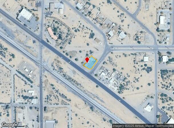
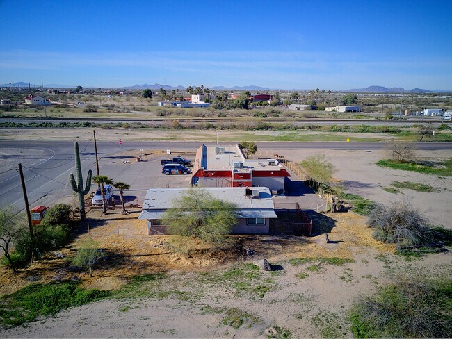
3902 W Frontier St, Eloy, AZ 85131

NEARBY LISTINGS FOR SALE OR LEASE
-
-
View all Eloy listings for sale on LoopNet.com
Property Detail
3902 W Frontier St
404-10-037B
Toltec Arizona Valley Unit 07
Storebuilding
A PRT OF NW NW OF SEC 27-7S-7E BEG E-466.90' & S-49 DEG E-112.05' FR NW COR OF SAID SEC 27; TH S-49 DEG E-100.24' TH S-36 DEG W-12 6.58' TH WLY 39.27' ALNG 90 DEG CURVE TH N-53 DEG W-75' TH N-36 D EG E-158.52' TO POB SEC 27-7S-7E .36 AC
X
Pinal
04021C1590F
Arizona
2024
0.36 AC
2025
Outlying Pinal County
002001
Phoenix
3,129 SF
Phoenix-Mesa-Chandler, AZ
DEMOGRAPHICS near 3902 W Frontier St
1 Mile
3 Mile
5 Mile
2024 Total Population
1,272
7,100
25,941
2029 Population
1,638
9,226
33,620
Pop Growth 2024-2029
+ 28.77%
+ 29.94%
+ 29.60%
Average Age
36
51
44
2024 Total Households
421
2,966
10,007
HH Growth 2024-2029
+ 28.50%
+ 29.80%
+ 29.55%
Median Household Inc
$59,999
$76,297
$52,259
Avg Household Size
3.00
2.30
2.50
2024 Avg HH Vehicles
2.00
2.00
2.00
Median Home Value
$102,232
$335,332
$191,529
Median Year Built
1997
2009
2004
Nearby Places
Map Layers
Map Styles
 Street
 Aerial
- Restaurants
- Banks
- Shops
- Fitness
- Groceries
SALE & LEASE HISTORY
LISTING DATE
SALE/LEASE

Sep 24, 2016
For Sale
Nov 20, 2017
For Sale
Nov 15, 2016
For Sale
Nov 01, 2018
For Sale
Feb 27, 2020
For Sale
Apr 05, 2021
For Sale
Nearby Properties
Address
Land Use
TOTAL SIZE
Lot Size
Zoning
Address
Land Use
TOTAL SIZE
Lot Size
Zoning
134,131 SF
44.33 AC
Address
Land Use
TOTAL SIZE
Lot Size
Zoning
37,469 SF
20.01 AC
UNDESIGNAT
Address
Land Use
TOTAL SIZE
Lot Size
Zoning
71,361 SF
15.19 AC
Address
Land Use
TOTAL SIZE
Lot Size
Zoning
107,496 SF
20 AC
UNDESIGNAT
Address
Land Use
TOTAL SIZE
Lot Size
Zoning
11,382 SF
13.33 AC
Address
Land Use
TOTAL SIZE
Lot Size
Zoning
27.14 AC
UNDESIGNAT
Address
Land Use
TOTAL SIZE
Lot Size
Zoning
Address
Land Use
TOTAL SIZE
Lot Size
Zoning
36,480 SF
18.12 AC
UNDESIGNAT
Address
Land Use
TOTAL SIZE
Lot Size
Zoning
70,027 SF
9.28 AC
Address
Land Use
TOTAL SIZE
Lot Size
Zoning
16,305 SF
43.90 AC
UNDESIGNAT
Address
Land Use
TOTAL SIZE
Lot Size
Zoning
Address
Land Use
TOTAL SIZE
Lot Size
Zoning
24,543 SF
2.28 AC
UNDESIGNAT
Address
Land Use
TOTAL SIZE
Lot Size
Zoning
46.81 AC
Address
Land Use
TOTAL SIZE
Lot Size
Zoning
53.77 AC
UNDESIGNAT
Address
Land Use
TOTAL SIZE
Lot Size
Zoning
14,400 SF
40 AC
Address
Land Use
TOTAL SIZE
Lot Size
Zoning
352 SF
22.81 AC
UNDESIGNAT
Address
Land Use
TOTAL SIZE
Lot Size
Zoning
60.31 AC
UNDESIGNAT
Address
Land Use
TOTAL SIZE
Lot Size
Zoning
16,393 SF
116.73 AC
UNDESIGNAT
Address
Land Use
TOTAL SIZE
Lot Size
Zoning
27,639 SF
2.82 AC
UNDESIGNAT
Address
Land Use
TOTAL SIZE
Lot Size
Zoning
239.09 AC
UNDESIGNAT
Address
Land Use
TOTAL SIZE
Lot Size
Zoning
28.93 AC
Address
Land Use
TOTAL SIZE
Lot Size
Zoning
8,988 SF
0.93 AC
Address
Land Use
TOTAL SIZE
Lot Size
Zoning
29,516 SF
4.09 AC
Address
Land Use
TOTAL SIZE
Lot Size
Zoning
13,442 SF
1.79 AC
UNDESIGNAT
Address
Land Use
TOTAL SIZE
Lot Size
Zoning
8,320 SF
0.90 AC
Address
Land Use
TOTAL SIZE
Lot Size
Zoning
5,624 SF
11.15 AC
UNDESIGNAT
Address
Land Use
TOTAL SIZE
Lot Size
Zoning
26,438 SF
2.92 AC
UNDESIGNAT
Address
Land Use
TOTAL SIZE
Lot Size
Zoning
10,911 SF
176.48 AC
UNDESIGNAT
Address
Land Use
TOTAL SIZE
Lot Size
Zoning
10,540 SF
3.78 AC
UNDESIGNAT
The World's #1 Commercial Real Estate Marketplace
Connect with us
© 2026 CoStar Group
The information above has been obtained from sources believed reliable. While we do not doubt its accuracy we have not verified it and make no guarantee, warranty or representation about it. It is your responsibility to independently confirm its accuracy and completeness. Any projections, opinions, assumptions, or estimates used are for example only and do not represent the current or future performance of the property. The value of this transaction to you depends on tax and other factors which should be evaluated by your tax, financial, and legal advisors. You and your advisors should conduct a careful, independent investigation of the property to determine to your satisfaction the suitability of the property for your needs.