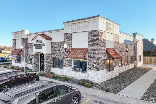
Property Record
3903 98Th St, Lubbock, TX 79423


Current Lease Availabilities
Property Detail
3903 98Th St
R334860
RAVENWOOD TR D
Officebuilding
Lubbock
B and X Area of moderate flood hazard, usually the area between the limits of the 100-year and 500-year floods.
Texas
2024
0.47 AC
2025
South Outer Lubbock
010510
Lubbock
3,776 SF
Lubbock, TX
NEARBY LISTINGS FOR SALE OR LEASE
DEMOGRAPHICS near 3903 98Th St
1 mile
3 mile
5 mile
2025 Total Population
11,327
87,901
176,383
2030 Population
11,780
91,695
184,427
Pop Growth 2025-2030
+ 4.00%
+ 4.32%
+ 4.56%
Average Age
43
39
37
2025 Total Households
4,685
35,526
70,164
HH Growth 2025-2030
+ 4.25%
+ 4.45%
+ 4.73%
Median Household Inc
$108,796
$79,274
$66,830
Avg Household Size
2.40
2.40
2.50
2025 Avg HH Vehicles
2.00
2.00
2.00
Median Home Value
$327,366
$256,667
$236,319
Median Year Built
1991
1989
1985
Nearby Places
Map Layers
Map Styles
 Street
 Aerial
Transit
 Traffic
 Biking
Places
Listings with unknown addresses are not visible on the map
- Restaurants
- Banks
- Shops
- Fitness
- Groceries
PUBLIC TRANSPORTATION
AIRPORT
Lubbock Preston Smith International
Drive
Walk
Distance
Lubbock Preston Smith International
32 min
19.5 mi
Freight Ports
Tulsa Port Of Catoosa
Drive
Walk
Distance
Tulsa Port Of Catoosa
515 min
476.4 mi
Nearby Properties
Address
Land Use
TOTAL SIZE
Lot Size
Zoning
Address
Land Use
TOTAL SIZE
Lot Size
Zoning
791,096 SF
63.76 AC
Address
Land Use
TOTAL SIZE
Lot Size
Zoning
329,448 SF
13.27 AC
Address
Land Use
TOTAL SIZE
Lot Size
Zoning
176,165 SF
36.61 AC
Address
Land Use
TOTAL SIZE
Lot Size
Zoning
418,925 SF
37.22 AC
Address
Land Use
TOTAL SIZE
Lot Size
Zoning
137,860 SF
13.89 AC
Address
Land Use
TOTAL SIZE
Lot Size
Zoning
189,540 SF
20.95 AC
Address
Land Use
TOTAL SIZE
Lot Size
Zoning
187,545 SF
11.27 AC
Address
Land Use
TOTAL SIZE
Lot Size
Zoning
138,202 SF
11.33 AC
Address
Land Use
TOTAL SIZE
Lot Size
Zoning
172,263 SF
11.01 AC
Address
Land Use
TOTAL SIZE
Lot Size
Zoning
167,208 SF
10.09 AC
Address
Land Use
TOTAL SIZE
Lot Size
Zoning
169,139 SF
12.07 AC
Address
Land Use
TOTAL SIZE
Lot Size
Zoning
157,644 SF
9.69 AC
Address
Land Use
TOTAL SIZE
Lot Size
Zoning
172,627 SF
8.12 AC
Address
Land Use
TOTAL SIZE
Lot Size
Zoning
199,854 SF
19.21 AC
Address
Land Use
TOTAL SIZE
Lot Size
Zoning
220,236 SF
13.42 AC
Address
Land Use
TOTAL SIZE
Lot Size
Zoning
198,209 SF
9.98 AC
Address
Land Use
TOTAL SIZE
Lot Size
Zoning
60,258 SF
8.99 AC
Address
Land Use
TOTAL SIZE
Lot Size
Zoning
49,538 SF
3.65 AC
Address
Land Use
TOTAL SIZE
Lot Size
Zoning
65,582 SF
3.74 AC
Address
Land Use
TOTAL SIZE
Lot Size
Zoning
57,897 SF
4.24 AC
Address
Land Use
TOTAL SIZE
Lot Size
Zoning
75,080 SF
0.04 AC
Address
Land Use
TOTAL SIZE
Lot Size
Zoning
63,341 SF
9.31 AC
Address
Land Use
TOTAL SIZE
Lot Size
Zoning
177,154 SF
8.79 AC
Address
Land Use
TOTAL SIZE
Lot Size
Zoning
83,300 SF
2.07 AC
Address
Land Use
TOTAL SIZE
Lot Size
Zoning
175,958 SF
8.13 AC
Address
Land Use
TOTAL SIZE
Lot Size
Zoning
88,998 SF
7.56 AC
Address
Land Use
TOTAL SIZE
Lot Size
Zoning
125,017 SF
6.95 AC
Address
Land Use
TOTAL SIZE
Lot Size
Zoning
66,804 SF
8.24 AC
Address
Land Use
TOTAL SIZE
Lot Size
Zoning
65,798 SF
4.11 AC
Address
Land Use
TOTAL SIZE
Lot Size
Zoning
65,986 SF
7.72 AC
The World's #1 Commercial Real Estate Marketplace
Connect with us
© 2026 CoStar Group
The information above has been obtained from sources believed reliable. While we do not doubt its accuracy we have not verified it and make no guarantee, warranty or representation about it. It is your responsibility to independently confirm its accuracy and completeness. Any projections, opinions, assumptions, or estimates used are for example only and do not represent the current or future performance of the property. The value of this transaction to you depends on tax and other factors which should be evaluated by your tax, financial, and legal advisors. You and your advisors should conduct a careful, independent investigation of the property to determine to your satisfaction the suitability of the property for your needs.