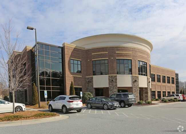
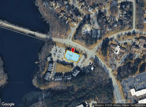
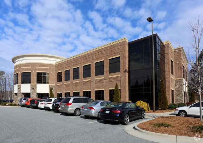
Property Record
3903 N Elm St, Greensboro, NC 27455
NEARBY LISTINGS FOR SALE OR LEASE
Property Detail
3903 N Elm St
Greensboro-High Point, NC
Brownstone Village
0216574
BROWNSTONE VILLAGE, PB177-102 LO:23 PH:1 PL:177-101
Commercialnec
Guilford
X
North Carolina
3710786700J
23
2024
0.53 AC
2025
NW Guilford County
015703
Greensboro/Winston-Salem
35,854 SF
DEMOGRAPHICS near 3903 N Elm St
1 Mile
3 Mile
5 Mile
2024 Total Population
6,586
55,662
130,803
2029 Population
6,508
55,226
130,570
Pop Growth 2024-2029
(1.18%)
(0.78%)
(0.18%)
Average Age
42
40
40
2024 Total Households
2,801
24,065
53,783
HH Growth 2024-2029
(1.21%)
(0.86%)
(0.19%)
Median Household Inc
$86,190
$63,292
$65,799
Avg Household Size
2.30
2.20
2.30
2024 Avg HH Vehicles
2.00
2.00
2.00
Median Home Value
$269,288
$216,898
$245,784
Median Year Built
1996
1987
1983
Nearby Places
Map Layers
Map Styles
 Street
 Aerial
- Restaurants
- Banks
- Shops
- Fitness
- Groceries
PUBLIC TRANSPORTATION
COMMUTER RAIL
Greensboro Station (Piedmont - North Carolina by Train (NC Train))
DRIVE
WALK
Distance
Greensboro Station (Piedmont - North Carolina by Train (NC Train))
12 min
5.5 mi
AIRPORT
Piedmont Triad International
DRIVE
WALK
Distance
Piedmont Triad International
20 min
11.1 mi
Nearby Properties
Address
Land Use
TOTAL SIZE
Lot Size
Zoning
Address
Land Use
TOTAL SIZE
Lot Size
Zoning
106,706 SF
343.57 AC
PI
Address
Land Use
TOTAL SIZE
Lot Size
Zoning
223,891 SF
10.53 AC
PUD
Address
Land Use
TOTAL SIZE
Lot Size
Zoning
281,337 SF
20.64 AC
PUD
Address
Land Use
TOTAL SIZE
Lot Size
Zoning
222,661 SF
51.39 AC
R-3
Address
Land Use
TOTAL SIZE
Lot Size
Zoning
263,148 SF
32.18 AC
RM-8
Address
Land Use
TOTAL SIZE
Lot Size
Zoning
252,109 SF
8.83 AC
PUD
Address
Land Use
TOTAL SIZE
Lot Size
Zoning
336,133 SF
23.93 AC
CU-RM-12
Address
Land Use
TOTAL SIZE
Lot Size
Zoning
171,358 SF
11.91 AC
PUD
Address
Land Use
TOTAL SIZE
Lot Size
Zoning
223,272 SF
9.91 AC
RM-26
Address
Land Use
TOTAL SIZE
Lot Size
Zoning
302,048 SF
24.45 AC
RM-12
Address
Land Use
TOTAL SIZE
Lot Size
Zoning
206,820 SF
14.59 AC
C-H
Address
Land Use
TOTAL SIZE
Lot Size
Zoning
194,064 SF
22.83 AC
RM-12
Address
Land Use
TOTAL SIZE
Lot Size
Zoning
316,644 SF
22.31 AC
RM-12
Address
Land Use
TOTAL SIZE
Lot Size
Zoning
259,434 SF
23.69 AC
RM-12
Address
Land Use
TOTAL SIZE
Lot Size
Zoning
38,940 SF
19.33 AC
R-3
Address
Land Use
TOTAL SIZE
Lot Size
Zoning
168,798 SF
15.45 AC
RM-12
Address
Land Use
TOTAL SIZE
Lot Size
Zoning
236,995 SF
14.09 AC
RM-18
Address
Land Use
TOTAL SIZE
Lot Size
Zoning
99,926 SF
8.13 AC
O
Address
Land Use
TOTAL SIZE
Lot Size
Zoning
189,979 SF
44.76 AC
PI
Address
Land Use
TOTAL SIZE
Lot Size
Zoning
191,654 SF
11.31 AC
RM-12
Address
Land Use
TOTAL SIZE
Lot Size
Zoning
275,083 SF
12.91 AC
RM-18
Address
Land Use
TOTAL SIZE
Lot Size
Zoning
119,780 SF
8.50 AC
PUD
Address
Land Use
TOTAL SIZE
Lot Size
Zoning
127,976 SF
40.04 AC
R-3
Address
Land Use
TOTAL SIZE
Lot Size
Zoning
167,490 SF
11.51 AC
C-H
Address
Land Use
TOTAL SIZE
Lot Size
Zoning
227,536 SF
20.57 AC
RM-12
Address
Land Use
TOTAL SIZE
Lot Size
Zoning
103,218 SF
11.65 AC
RM-12
Address
Land Use
TOTAL SIZE
Lot Size
Zoning
65,185 SF
26.29 AC
R-3
Address
Land Use
TOTAL SIZE
Lot Size
Zoning
88,786 SF
6.97 AC
O
Address
Land Use
TOTAL SIZE
Lot Size
Zoning
122,067 SF
10.60 AC
C-H
Address
Land Use
TOTAL SIZE
Lot Size
Zoning
110,908 SF
10.10 AC
C-H
The World's #1 Commercial Real Estate Marketplace
Connect with us
© 2026 CoStar Group
The information above has been obtained from sources believed reliable. While we do not doubt its accuracy we have not verified it and make no guarantee, warranty or representation about it. It is your responsibility to independently confirm its accuracy and completeness. Any projections, opinions, assumptions, or estimates used are for example only and do not represent the current or future performance of the property. The value of this transaction to you depends on tax and other factors which should be evaluated by your tax, financial, and legal advisors. You and your advisors should conduct a careful, independent investigation of the property to determine to your satisfaction the suitability of the property for your needs.