Property Record
3906 E Main St, Columbus, OH 43213
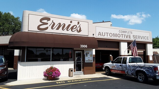

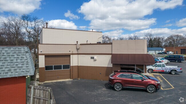
Property Detail
3906 E Main St
Columbus, OH
3906 E MAIN ST BLOWER SUB 150SE LOTS 6-8 EX SE COR
090-005884
Franklin
Parkingstructure
Ohio
2024
6-8
2025
0.51 AC
009220
East
5,535 SF
Columbus
NEARBY LISTINGS FOR SALE OR LEASE
DEMOGRAPHICS near 3906 E Main St
1 mile
3 mile
5 mile
2025 Total Population
17,769
112,502
280,004
2030 Population
18,267
116,140
290,525
Pop Growth 2025-2030
+ 2.80%
+ 3.23%
+ 3.76%
Average Age
37
38
38
2025 Total Households
6,856
47,179
116,431
HH Growth 2025-2030
+ 2.96%
+ 3.49%
+ 3.98%
Median Household Inc
$46,964
$51,545
$55,740
Avg Household Size
2.50
2.30
2.30
2025 Avg HH Vehicles
2.00
2.00
2.00
Median Home Value
$148,886
$211,039
$235,637
Median Year Built
1959
1965
1968
Nearby Places
Map Layers
Map Styles
 Street
 Aerial
Transit
 Traffic
 Biking
Places
Listings with unknown addresses are not visible on the map
- Restaurants
- Banks
- Shops
- Fitness
- Groceries
PUBLIC TRANSPORTATION
AIRPORT
John Glenn Columbus International
Drive
Walk
Distance
John Glenn Columbus International
10 min
5.3 mi
Rickenbacker International
Drive
Walk
Distance
Rickenbacker International
21 min
12.4 mi
Freight Ports
Port of Toledo
Drive
Walk
Distance
Port of Toledo
191 min
150.6 mi
SALE & LEASE HISTORY
LISTING DATE
SALE/LEASE

Sep 06, 2019
For Sale
Aug 17, 2018
For Sale
Nearby Properties
Address
Land Use
TOTAL SIZE
Lot Size
Zoning
Address
Land Use
TOTAL SIZE
Lot Size
Zoning
316,415 SF
415.78 AC
Address
Land Use
TOTAL SIZE
Lot Size
Zoning
1,256,678 SF
1,292.62 AC
Address
Land Use
TOTAL SIZE
Lot Size
Zoning
Address
Land Use
TOTAL SIZE
Lot Size
Zoning
180,383 SF
15.54 AC
Address
Land Use
TOTAL SIZE
Lot Size
Zoning
184,777 SF
3.67 AC
Address
Land Use
TOTAL SIZE
Lot Size
Zoning
573,031 SF
5.88 AC
Address
Land Use
TOTAL SIZE
Lot Size
Zoning
122,526 SF
27 AC
Address
Land Use
TOTAL SIZE
Lot Size
Zoning
514,341 SF
46.79 AC
Address
Land Use
TOTAL SIZE
Lot Size
Zoning
183,352 SF
55.41 AC
Address
Land Use
TOTAL SIZE
Lot Size
Zoning
282,035 SF
29.29 AC
Address
Land Use
TOTAL SIZE
Lot Size
Zoning
398,836 SF
14.37 AC
Address
Land Use
TOTAL SIZE
Lot Size
Zoning
143,397 SF
25.50 AC
Address
Land Use
TOTAL SIZE
Lot Size
Zoning
245,142 SF
11.56 AC
Address
Land Use
TOTAL SIZE
Lot Size
Zoning
66,177 SF
11.17 AC
Address
Land Use
TOTAL SIZE
Lot Size
Zoning
706,471 SF
41.34 AC
Address
Land Use
TOTAL SIZE
Lot Size
Zoning
217,088 SF
10.67 AC
Address
Land Use
TOTAL SIZE
Lot Size
Zoning
205,370 SF
19.82 AC
Address
Land Use
TOTAL SIZE
Lot Size
Zoning
1,264,151 SF
58.42 AC
Address
Land Use
TOTAL SIZE
Lot Size
Zoning
125,219 SF
3.49 AC
Address
Land Use
TOTAL SIZE
Lot Size
Zoning
170,209 SF
15.03 AC
Address
Land Use
TOTAL SIZE
Lot Size
Zoning
142,542 SF
6.55 AC
Address
Land Use
TOTAL SIZE
Lot Size
Zoning
188,305 SF
27.46 AC
Address
Land Use
TOTAL SIZE
Lot Size
Zoning
142,542 SF
3.95 AC
Address
Land Use
TOTAL SIZE
Lot Size
Zoning
158,325 SF
34.39 AC
Address
Land Use
TOTAL SIZE
Lot Size
Zoning
102,412 SF
11.86 AC
Address
Land Use
TOTAL SIZE
Lot Size
Zoning
267,596 SF
5.76 AC
Address
Land Use
TOTAL SIZE
Lot Size
Zoning
471,738 SF
35.43 AC
Address
Land Use
TOTAL SIZE
Lot Size
Zoning
79,472 SF
8.45 AC
Address
Land Use
TOTAL SIZE
Lot Size
Zoning
107,998 SF
14.65 AC
Address
Land Use
TOTAL SIZE
Lot Size
Zoning
175,313 SF
27.10 AC
The World's #1 Commercial Real Estate Marketplace
Connect with us
© 2026 CoStar Group
The information above has been obtained from sources believed reliable. While we do not doubt its accuracy we have not verified it and make no guarantee, warranty or representation about it. It is your responsibility to independently confirm its accuracy and completeness. Any projections, opinions, assumptions, or estimates used are for example only and do not represent the current or future performance of the property. The value of this transaction to you depends on tax and other factors which should be evaluated by your tax, financial, and legal advisors. You and your advisors should conduct a careful, independent investigation of the property to determine to your satisfaction the suitability of the property for your needs.