Property Record
3906 E Main St, Knoxville, IA 50138
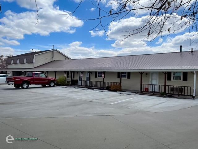

This Property Is For Sale
Property Detail
3906 E Main St
0557501500
SE NE E420'S OF HWY SE NE E420'S OF HWY ROW EXC PARCELS C&D ROW EXC PARCELS C&D
Bartavern
MARION
B and X Area of moderate flood hazard, usually the area between the limits of the 100-year and 500-year floods.
Iowa
2025
2.55 AC
2025
Iowa Southeast Area
030402
Other Market Areas
5,504 SF
Pella, IA
NEARBY LISTINGS FOR SALE OR LEASE
-
-
View all Knoxville listings for sale on LoopNet.com
DEMOGRAPHICS near 3906 E Main St
1 mile
3 mile
5 mile
2025 Total Population
418
8,586
10,442
2030 Population
418
8,745
10,623
Pop Growth 2025-2030
0.00%
+ 1.85%
+ 1.73%
Average Age
44
42
42
2025 Total Households
160
3,623
4,368
HH Growth 2025-2030
0.00%
+ 2.01%
+ 1.90%
Median Household Inc
$113,020
$70,766
$74,651
Avg Household Size
2.50
2.30
2.30
2025 Avg HH Vehicles
3.00
2.00
2.00
Median Home Value
$311,765
$179,114
$189,083
Median Year Built
1984
1970
1972
Nearby Places
Map Layers
Map Styles
 Street
 Aerial
Layers
 Traffic
 Biking
Places
Listings with unknown addresses are not visible on the map
- Restaurants
- Banks
- Shops
- Fitness
- Groceries
Nearby Properties
Address
Land Use
TOTAL SIZE
Lot Size
Zoning
Address
Land Use
TOTAL SIZE
Lot Size
Zoning
2,910 SF
13.68 AC
Address
Land Use
TOTAL SIZE
Lot Size
Zoning
2,220 SF
14.53 AC
Address
Land Use
TOTAL SIZE
Lot Size
Zoning
87,846 SF
Address
Land Use
TOTAL SIZE
Lot Size
Zoning
160 SF
64 AC
Address
Land Use
TOTAL SIZE
Lot Size
Zoning
123,863 SF
Address
Land Use
TOTAL SIZE
Lot Size
Zoning
373,990 SF
23.09 AC
Address
Land Use
TOTAL SIZE
Lot Size
Zoning
109,538 SF
13.31 AC
Address
Land Use
TOTAL SIZE
Lot Size
Zoning
87,846 SF
40 AC
Address
Land Use
TOTAL SIZE
Lot Size
Zoning
27,147 SF
21.79 AC
Address
Land Use
TOTAL SIZE
Lot Size
Zoning
2,179 SF
37 AC
Address
Land Use
TOTAL SIZE
Lot Size
Zoning
5,220 SF
3.13 AC
Address
Land Use
TOTAL SIZE
Lot Size
Zoning
42,892 SF
3.43 AC
Address
Land Use
TOTAL SIZE
Lot Size
Zoning
24,882 SF
1.41 AC
Address
Land Use
TOTAL SIZE
Lot Size
Zoning
16,130 SF
10 AC
Address
Land Use
TOTAL SIZE
Lot Size
Zoning
40,637 SF
Address
Land Use
TOTAL SIZE
Lot Size
Zoning
800 SF
2.73 AC
Address
Land Use
TOTAL SIZE
Lot Size
Zoning
15,509 SF
2.96 AC
Address
Land Use
TOTAL SIZE
Lot Size
Zoning
45,447 SF
7.20 AC
Address
Land Use
TOTAL SIZE
Lot Size
Zoning
133,833 SF
19.18 AC
Address
Land Use
TOTAL SIZE
Lot Size
Zoning
30,844 SF
6.39 AC
Address
Land Use
TOTAL SIZE
Lot Size
Zoning
7,200 SF
4.52 AC
Address
Land Use
TOTAL SIZE
Lot Size
Zoning
9,780 SF
Address
Land Use
TOTAL SIZE
Lot Size
Zoning
10,732 SF
0.66 AC
Address
Land Use
TOTAL SIZE
Lot Size
Zoning
86,200 SF
6.76 AC
Address
Land Use
TOTAL SIZE
Lot Size
Zoning
14,862 SF
1.85 AC
Address
Land Use
TOTAL SIZE
Lot Size
Zoning
20,814 SF
2.07 AC
Address
Land Use
TOTAL SIZE
Lot Size
Zoning
2,408 SF
5.08 AC
Address
Land Use
TOTAL SIZE
Lot Size
Zoning
22,538 SF
2.66 AC
Address
Land Use
TOTAL SIZE
Lot Size
Zoning
29,132 SF
55.01 AC
Address
Land Use
TOTAL SIZE
Lot Size
Zoning
28,015 SF
3.10 AC
The World's #1 Commercial Real Estate Marketplace
Connect with us
© 2026 CoStar Group
The information above has been obtained from sources believed reliable. While we do not doubt its accuracy we have not verified it and make no guarantee, warranty or representation about it. It is your responsibility to independently confirm its accuracy and completeness. Any projections, opinions, assumptions, or estimates used are for example only and do not represent the current or future performance of the property. The value of this transaction to you depends on tax and other factors which should be evaluated by your tax, financial, and legal advisors. You and your advisors should conduct a careful, independent investigation of the property to determine to your satisfaction the suitability of the property for your needs.