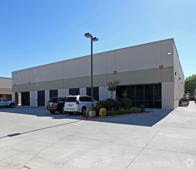
Property Record
3906 Kristi Ct, Sacramento, CA 95827
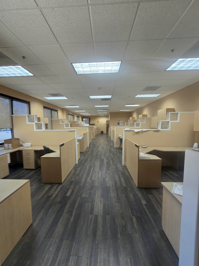

Current Lease Availabilities
NEARBY LISTINGS FOR SALE OR LEASE
Property Detail
3906 Kristi Ct
Sacramento--Roseville--Arden-Arcade, CA
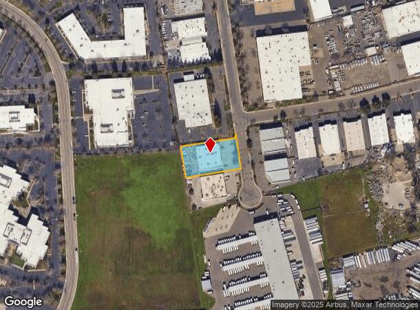
Parcel Map
067-0160-076
PARCEL MAP, LOT 1
Warehouse
Sacramento
X
California
06067C0215H
1
2024
0.82 AC
2025
Mather
009005
Sacramento
10,588 SF
DEMOGRAPHICS near 3906 Kristi Ct
1 Mile
3 Mile
5 Mile
2024 Total Population
8,495
78,723
201,252
2029 Population
8,510
79,207
202,801
Pop Growth 2024-2029
+ 0.18%
+ 0.61%
+ 0.77%
Average Age
38
38
39
2024 Total Households
2,995
29,182
76,908
HH Growth 2024-2029
+ 0.17%
+ 0.62%
+ 0.79%
Median Household Inc
$75,359
$80,010
$79,649
Avg Household Size
2.80
2.60
2.50
2024 Avg HH Vehicles
2.00
2.00
2.00
Median Home Value
$348,214
$411,761
$457,163
Median Year Built
1976
1975
1973
Nearby Places
Map Layers
Map Styles
 Street
 Aerial
- Restaurants
- Banks
- Shops
- Fitness
- Groceries
PUBLIC TRANSPORTATION
AIRPORT
Sacramento International
DRIVE
WALK
Distance
Sacramento International
33 min
23.4 mi
Freight Ports
Port of Stockton
DRIVE
WALK
Distance
Port of Stockton
66 min
49.2 mi
Nearby Properties
Address
Land Use
TOTAL SIZE
Lot Size
Zoning
Address
Land Use
TOTAL SIZE
Lot Size
Zoning
266,841 SF
47.29 AC
RD-5
Address
Land Use
TOTAL SIZE
Lot Size
Zoning
223,046 SF
10.99 AC
RD 20
Address
Land Use
TOTAL SIZE
Lot Size
Zoning
109,805 SF
20.04 AC
OPMU
Address
Land Use
TOTAL SIZE
Lot Size
Zoning
181,573 SF
12.10 AC
SPA (MFSPA
Address
Land Use
TOTAL SIZE
Lot Size
Zoning
168,846 SF
7.58 AC
RD-30 (PC)
Address
Land Use
TOTAL SIZE
Lot Size
Zoning
139,500 SF
5.21 AC
MP
Address
Land Use
TOTAL SIZE
Lot Size
Zoning
162,023 SF
8.96 AC
OIMU
Address
Land Use
TOTAL SIZE
Lot Size
Zoning
119,824 SF
7.64 AC
RD-30 (PC)
Address
Land Use
TOTAL SIZE
Lot Size
Zoning
0.21 AC
RD-5
Address
Land Use
TOTAL SIZE
Lot Size
Zoning
6.31 AC
RC (ZSPA)
Address
Land Use
TOTAL SIZE
Lot Size
Zoning
135,375 SF
7.40 AC
RD-30
Address
Land Use
TOTAL SIZE
Lot Size
Zoning
221,337 SF
12.19 AC
RD 25
Address
Land Use
TOTAL SIZE
Lot Size
Zoning
132,149 SF
8.29 AC
OPMU
Address
Land Use
TOTAL SIZE
Lot Size
Zoning
95,174 SF
5.29 AC
SPA (MFSPA
Address
Land Use
TOTAL SIZE
Lot Size
Zoning
198,131 SF
13.36 AC
BP
Address
Land Use
TOTAL SIZE
Lot Size
Zoning
156,032 SF
9.31 AC
OPMU
Address
Land Use
TOTAL SIZE
Lot Size
Zoning
169,618 SF
10.44 AC
RD-4
Address
Land Use
TOTAL SIZE
Lot Size
Zoning
198,413 SF
9.24 AC
RD 30
Address
Land Use
TOTAL SIZE
Lot Size
Zoning
12.47 AC
RD 30
Address
Land Use
TOTAL SIZE
Lot Size
Zoning
457,088 SF
12.50 AC
RD 30
Address
Land Use
TOTAL SIZE
Lot Size
Zoning
98,767 SF
6.43 AC
BP (ZSPA)
Address
Land Use
TOTAL SIZE
Lot Size
Zoning
302,966 SF
15.94 AC
RD 30
Address
Land Use
TOTAL SIZE
Lot Size
Zoning
258,819 SF
13.47 AC
RD 30
Address
Land Use
TOTAL SIZE
Lot Size
Zoning
8,724 SF
101.84 AC
M-2 (SM)
Address
Land Use
TOTAL SIZE
Lot Size
Zoning
110,960 SF
6.62 AC
SPA (MFSPA
Address
Land Use
TOTAL SIZE
Lot Size
Zoning
184,249 SF
10.72 AC
OIMU (FBSP
Address
Land Use
TOTAL SIZE
Lot Size
Zoning
100,000 SF
7.03 AC
SPA (MFSPA
Address
Land Use
TOTAL SIZE
Lot Size
Zoning
203,374 SF
12 AC
RD-20
Address
Land Use
TOTAL SIZE
Lot Size
Zoning
85,131 SF
4.90 AC
RD 20
Address
Land Use
TOTAL SIZE
Lot Size
Zoning
124,604 SF
8.50 AC
OPMU
The World's #1 Commercial Real Estate Marketplace
Connect with us
© 2025 CoStar Group
The information above has been obtained from sources believed reliable. While we do not doubt its accuracy we have not verified it and make no guarantee, warranty or representation about it. It is your responsibility to independently confirm its accuracy and completeness. Any projections, opinions, assumptions, or estimates used are for example only and do not represent the current or future performance of the property. The value of this transaction to you depends on tax and other factors which should be evaluated by your tax, financial, and legal advisors. You and your advisors should conduct a careful, independent investigation of the property to determine to your satisfaction the suitability of the property for your needs.