No Photo
Property Record
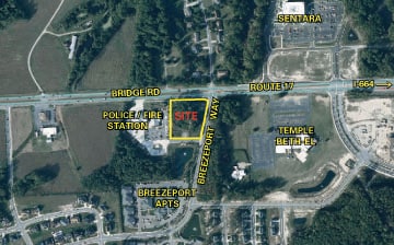
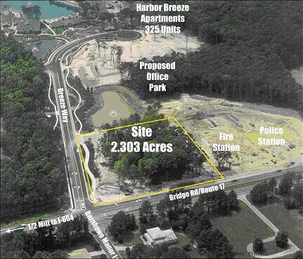
3907 Bridge Rd, Suffolk, VA 23435


Property Detail
3907 Bridge Rd
306000453
PAR.A3,REPLAT PAR.A2, HARBOUR BREEZE
Commercialnec
Suffolk City
GENERAL CO
Virginia
B and X Area of moderate flood hazard, usually the area between the limits of the 100-year and 500-year floods.
2.30 AC
2025
Harbourview/N Suffolk
2025
Hampton Roads
075205
Virginia Beach-Chesapeake-Norfolk, VA-NC
26,040 SF
NEARBY LISTINGS FOR SALE OR LEASE
-
-
-
-
Harbour View Boulevard at Harbour Pointe Dr
Suffolk, VA 23435
$942,500 - $6,771,500
1.30 - 6.96 AC Lot
Land
-
-
-
-
View all Suffolk listings for sale on LoopNet.com
DEMOGRAPHICS near 3907 Bridge Rd
1 mile
3 mile
5 mile
2025 Total Population
6,913
49,727
95,347
2030 Population
7,562
52,405
98,394
Pop Growth 2025-2030
+ 9.39%
+ 5.39%
+ 3.20%
Average Age
41
38
40
2025 Total Households
2,906
19,061
36,389
HH Growth 2025-2030
+ 9.29%
+ 5.50%
+ 3.26%
Median Household Inc
$73,320
$89,739
$96,592
Avg Household Size
2.30
2.60
2.60
2025 Avg HH Vehicles
2.00
2.00
2.00
Median Home Value
$424,731
$361,914
$361,040
Median Year Built
2006
1997
1988
Nearby Places
Map Layers
Map Styles
 Street
 Aerial
Layers
 Traffic
 Biking
Places
Listings with unknown addresses are not visible on the map
- Restaurants
- Banks
- Shops
- Fitness
- Groceries
PUBLIC TRANSPORTATION
AIRPORT
Norfolk International
Drive
Walk
Distance
Norfolk International
29 min
16.8 mi
Newport News/Williamsburg International
Drive
Walk
Distance
Newport News/Williamsburg International
36 min
26.1 mi
Freight Ports
Virginia Port Authority - Portsmouth
Drive
Walk
Distance
Virginia Port Authority - Portsmouth
16 min
8.8 mi
Nearby Properties
Address
Land Use
TOTAL SIZE
Lot Size
Zoning
Address
Land Use
TOTAL SIZE
Lot Size
Zoning
2,400 SF
125.24 AC
HEAVY INDU
Address
Land Use
TOTAL SIZE
Lot Size
Zoning
285,162 SF
101.91 AC
R10S: RESI
Address
Land Use
TOTAL SIZE
Lot Size
Zoning
13.52 AC
MIXED USE
Address
Land Use
TOTAL SIZE
Lot Size
Zoning
359,146 SF
16.95 AC
RMF1: MULT
Address
Land Use
TOTAL SIZE
Lot Size
Zoning
4,080 SF
41.46 AC
LIGHT INDU
Address
Land Use
TOTAL SIZE
Lot Size
Zoning
30.85 AC
PLANNED DE
Address
Land Use
TOTAL SIZE
Lot Size
Zoning
31,635 SF
10.36 AC
MIXED USE
Address
Land Use
TOTAL SIZE
Lot Size
Zoning
6,446 SF
8.76 AC
MIXED USE
Address
Land Use
TOTAL SIZE
Lot Size
Zoning
681,685 SF
52.59 AC
LIGHT INDU
Address
Land Use
TOTAL SIZE
Lot Size
Zoning
278,978 SF
26.63 AC
LIGHT INDU
Address
Land Use
TOTAL SIZE
Lot Size
Zoning
97,411 SF
17.90 AC
GENERAL CO
Address
Land Use
TOTAL SIZE
Lot Size
Zoning
46.66 AC
LIGHT INDU
Address
Land Use
TOTAL SIZE
Lot Size
Zoning
22,723 SF
10.97 AC
GENERAL CO
Address
Land Use
TOTAL SIZE
Lot Size
Zoning
166,481 SF
11.15 AC
OFFICE-INS
Address
Land Use
TOTAL SIZE
Lot Size
Zoning
43,917 SF
5.72 AC
MIXED USE
Address
Land Use
TOTAL SIZE
Lot Size
Zoning
15,746 SF
24.70 AC
GENERAL CO
Address
Land Use
TOTAL SIZE
Lot Size
Zoning
101,959 SF
12.65 AC
LIGHT INDU
Address
Land Use
TOTAL SIZE
Lot Size
Zoning
11.83 AC
OFFICE-INS
Address
Land Use
TOTAL SIZE
Lot Size
Zoning
126,000 SF
21.51 AC
LIGHT INDU
Address
Land Use
TOTAL SIZE
Lot Size
Zoning
41,440 SF
6.60 AC
LIGHT INDU
Address
Land Use
TOTAL SIZE
Lot Size
Zoning
235,968 SF
13.25 AC
RMF1: MULT
Address
Land Use
TOTAL SIZE
Lot Size
Zoning
222,810 SF
42.16 AC
MULTI: MUL
Address
Land Use
TOTAL SIZE
Lot Size
Zoning
165,034 SF
13.12 AC
URM
Address
Land Use
TOTAL SIZE
Lot Size
Zoning
224,077 SF
27.30 AC
B2: GENERA
Address
Land Use
TOTAL SIZE
Lot Size
Zoning
6,788 SF
19.93 AC
GENERAL CO
The World's #1 Commercial Real Estate Marketplace
Connect with us
© 2026 CoStar Group
The information above has been obtained from sources believed reliable. While we do not doubt its accuracy we have not verified it and make no guarantee, warranty or representation about it. It is your responsibility to independently confirm its accuracy and completeness. Any projections, opinions, assumptions, or estimates used are for example only and do not represent the current or future performance of the property. The value of this transaction to you depends on tax and other factors which should be evaluated by your tax, financial, and legal advisors. You and your advisors should conduct a careful, independent investigation of the property to determine to your satisfaction the suitability of the property for your needs.