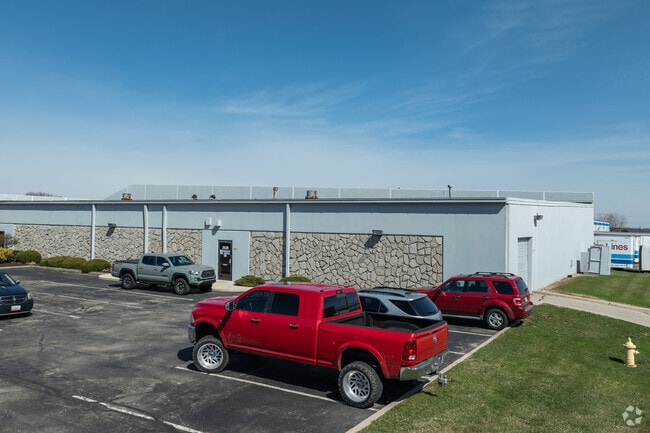
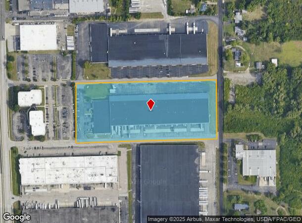
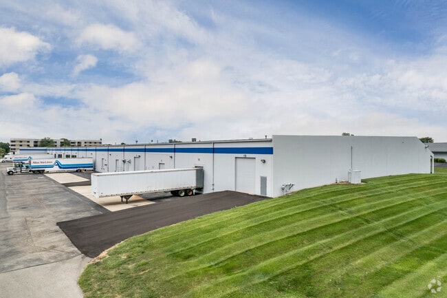
Property Record
3904 Image Dr, Vandalia, OH 45377

Current Lease Availabilities
NEARBY LISTINGS FOR SALE OR LEASE
Property Detail
3904 Image Dr
Dayton, OH
Corporate Center
B02-01213-0002
2 70/75 CORPORATE CENTER
Warehouse
Montgomery
X
Ohio
39113C0156E
2
2023
7.03 AC
2024
North Dayton
115011
Cincinnati/Dayton
125,000 SF
DEMOGRAPHICS near 3904 Image Dr
1 Mile
3 Mile
5 Mile
2024 Total Population
1,722
35,813
134,196
2029 Population
1,696
35,114
133,256
Pop Growth 2024-2029
(1.51%)
(1.95%)
(0.70%)
Average Age
43
42
40
2024 Total Households
702
15,473
56,193
HH Growth 2024-2029
(1.71%)
(1.99%)
(0.78%)
Median Household Inc
$70,535
$59,016
$55,739
Avg Household Size
2.30
2.20
2.30
2024 Avg HH Vehicles
2.00
2.00
2.00
Median Home Value
$186,781
$160,703
$146,338
Median Year Built
1969
1970
1967
Nearby Places
- Restaurants
- Banks
- Shops
- Fitness
- Groceries
PUBLIC TRANSPORTATION
AIRPORT
James M Cox Dayton International
DRIVE
WALK
Distance
James M Cox Dayton International
14 min
7.3 mi
Freight Ports
Port of Toledo
DRIVE
WALK
Distance
Port of Toledo
170 min
147.5 mi
Nearby Properties
Address
Land Use
TOTAL SIZE
Lot Size
Zoning
Address
Land Use
TOTAL SIZE
Lot Size
Zoning
923.52 AC
Address
Land Use
TOTAL SIZE
Lot Size
Zoning
30.29 AC
Address
Land Use
TOTAL SIZE
Lot Size
Zoning
22,133 SF
47.58 AC
Address
Land Use
TOTAL SIZE
Lot Size
Zoning
573,962 SF
1,128.84 AC
Address
Land Use
TOTAL SIZE
Lot Size
Zoning
5.92 AC
Address
Land Use
TOTAL SIZE
Lot Size
Zoning
144,340 SF
91.38 AC
Address
Land Use
TOTAL SIZE
Lot Size
Zoning
37.86 AC
Address
Land Use
TOTAL SIZE
Lot Size
Zoning
54,740 SF
8.01 AC
Address
Land Use
TOTAL SIZE
Lot Size
Zoning
12,660 SF
20.22 AC
Address
Land Use
TOTAL SIZE
Lot Size
Zoning
505,736 SF
45.42 AC
Address
Land Use
TOTAL SIZE
Lot Size
Zoning
313,421 SF
19.55 AC
Address
Land Use
TOTAL SIZE
Lot Size
Zoning
Address
Land Use
TOTAL SIZE
Lot Size
Zoning
51.78 AC
Address
Land Use
TOTAL SIZE
Lot Size
Zoning
183,333 SF
5.12 AC
Address
Land Use
TOTAL SIZE
Lot Size
Zoning
10.87 AC
Address
Land Use
TOTAL SIZE
Lot Size
Zoning
220,548 SF
23.11 AC
Address
Land Use
TOTAL SIZE
Lot Size
Zoning
1,080 SF
30 AC
Address
Land Use
TOTAL SIZE
Lot Size
Zoning
509,060 SF
31.03 AC
Address
Land Use
TOTAL SIZE
Lot Size
Zoning
239,750 SF
9.12 AC
Address
Land Use
TOTAL SIZE
Lot Size
Zoning
94,671 SF
6.42 AC
Address
Land Use
TOTAL SIZE
Lot Size
Zoning
93,360 SF
694.57 AC
Address
Land Use
TOTAL SIZE
Lot Size
Zoning
106,375 SF
2.26 AC
Address
Land Use
TOTAL SIZE
Lot Size
Zoning
10.25 AC
Address
Land Use
TOTAL SIZE
Lot Size
Zoning
193,311 SF
9.37 AC
Address
Land Use
TOTAL SIZE
Lot Size
Zoning
76,156 SF
97.13 AC
Address
Land Use
TOTAL SIZE
Lot Size
Zoning
92,615 SF
2.68 AC
Address
Land Use
TOTAL SIZE
Lot Size
Zoning
126,038 SF
13.78 AC
Address
Land Use
TOTAL SIZE
Lot Size
Zoning
17.54 AC
Address
Land Use
TOTAL SIZE
Lot Size
Zoning
263,022 SF
19.33 AC
Address
Land Use
TOTAL SIZE
Lot Size
Zoning
68,196 SF
3.55 AC
The World's #1 Commercial Real Estate Marketplace
Connect with us
© 2025 CoStar Group
The information above has been obtained from sources believed reliable. While we do not doubt its accuracy we have not verified it and make no guarantee, warranty or representation about it. It is your responsibility to independently confirm its accuracy and completeness. Any projections, opinions, assumptions, or estimates used are for example only and do not represent the current or future performance of the property. The value of this transaction to you depends on tax and other factors which should be evaluated by your tax, financial, and legal advisors. You and your advisors should conduct a careful, independent investigation of the property to determine to your satisfaction the suitability of the property for your needs.