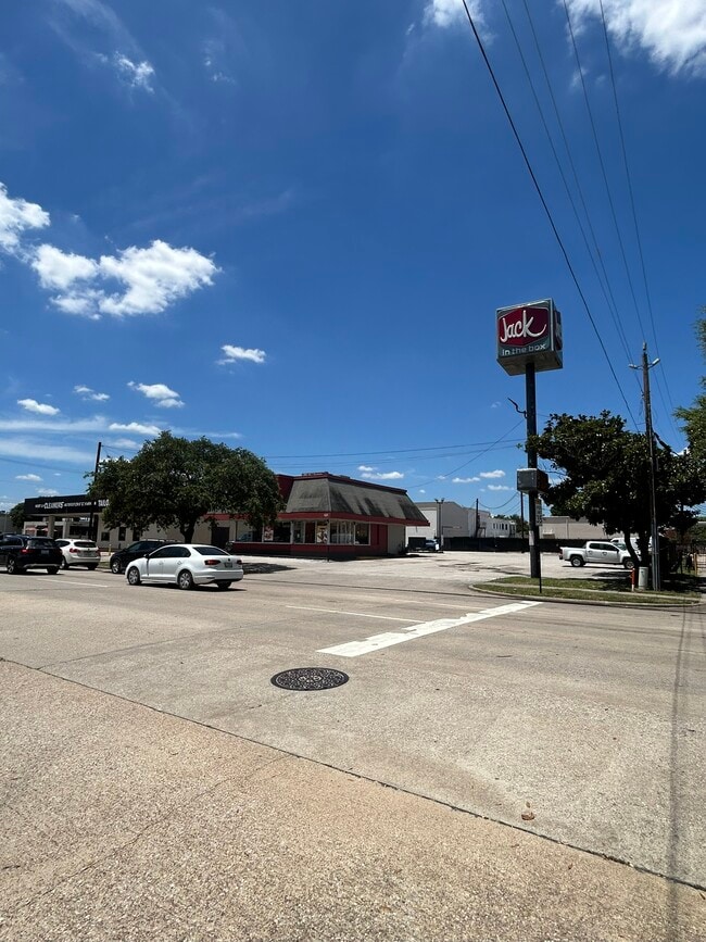
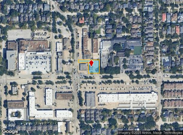
Property Record
3908 Bellaire Blvd, Houston, TX 77025

Current Lease Availabilities
NEARBY LISTINGS FOR SALE OR LEASE
Property Detail
3908 Bellaire Blvd
0090240000026
Cambridge Place
Restaurantdrivein
TRS 26A & 26C & TRS 1B & 2B BLK 7 CUNNINGHAM TERRACE CAMBRIDGE PLACE
X
Harris
48201C0855L
Texas
2024
0.50 AC
2025
Inner Loop University
412400
Houston
1,804 SF
Houston-The Woodlands-Sugar Land, TX
DEMOGRAPHICS near 3908 Bellaire Blvd
1 Mile
3 Mile
5 Mile
2024 Total Population
22,278
209,016
542,236
2029 Population
23,876
225,451
585,388
Pop Growth 2024-2029
+ 7.17%
+ 7.86%
+ 7.96%
Average Age
40
38
38
2024 Total Households
8,149
96,238
249,964
HH Growth 2024-2029
+ 7.49%
+ 8.19%
+ 8.30%
Median Household Inc
$196,422
$87,013
$79,458
Avg Household Size
2.70
2.10
2.10
2024 Avg HH Vehicles
2.00
2.00
1.00
Median Home Value
$1,055,556
$807,346
$508,251
Median Year Built
1995
1992
1988
Nearby Places
- Restaurants
- Banks
- Shops
- Fitness
- Groceries
PUBLIC TRANSPORTATION
COMMUTER RAIL
Houston (Sunset Limited - Amtrak)
DRIVE
WALK
Distance
Houston (Sunset Limited - Amtrak)
15 min
7.8 mi
AIRPORT
William P Hobby
DRIVE
WALK
Distance
William P Hobby
29 min
15.7 mi
George Bush Intcntl/Houston
DRIVE
WALK
Distance
George Bush Intcntl/Houston
36 min
26.2 mi
Freight Ports
Port of Houston
DRIVE
WALK
Distance
Port of Houston
26 min
16.0 mi
Nearby Properties
Address
Land Use
TOTAL SIZE
Lot Size
Zoning
Address
Land Use
TOTAL SIZE
Lot Size
Zoning
519,409 SF
1.52 AC
Address
Land Use
TOTAL SIZE
Lot Size
Zoning
576,253 SF
5.91 AC
Address
Land Use
TOTAL SIZE
Lot Size
Zoning
1,252,274 SF
2.02 AC
Address
Land Use
TOTAL SIZE
Lot Size
Zoning
716,631 SF
7.04 AC
Address
Land Use
TOTAL SIZE
Lot Size
Zoning
2,626,393 SF
6.70 AC
Address
Land Use
TOTAL SIZE
Lot Size
Zoning
1,880,742 SF
20.77 AC
Address
Land Use
TOTAL SIZE
Lot Size
Zoning
329,832 SF
1.75 AC
Address
Land Use
TOTAL SIZE
Lot Size
Zoning
704,249 SF
2.34 AC
Address
Land Use
TOTAL SIZE
Lot Size
Zoning
1,062,592 SF
7.41 AC
Address
Land Use
TOTAL SIZE
Lot Size
Zoning
1,044,305 SF
3.16 AC
Address
Land Use
TOTAL SIZE
Lot Size
Zoning
1,359,194 SF
Address
Land Use
TOTAL SIZE
Lot Size
Zoning
565,276 SF
1.35 AC
Address
Land Use
TOTAL SIZE
Lot Size
Zoning
402,467 SF
28.30 AC
Address
Land Use
TOTAL SIZE
Lot Size
Zoning
1,009,859 SF
28.73 AC
Address
Land Use
TOTAL SIZE
Lot Size
Zoning
771,702 SF
2.51 AC
Address
Land Use
TOTAL SIZE
Lot Size
Zoning
743,548 SF
3.40 AC
Address
Land Use
TOTAL SIZE
Lot Size
Zoning
464,134 SF
3.57 AC
Address
Land Use
TOTAL SIZE
Lot Size
Zoning
576,200 SF
2.65 AC
Address
Land Use
TOTAL SIZE
Lot Size
Zoning
701,043 SF
4.69 AC
Address
Land Use
TOTAL SIZE
Lot Size
Zoning
777,791 SF
47.90 AC
Address
Land Use
TOTAL SIZE
Lot Size
Zoning
549,506 SF
2.05 AC
Address
Land Use
TOTAL SIZE
Lot Size
Zoning
958,147 SF
16.60 AC
Address
Land Use
TOTAL SIZE
Lot Size
Zoning
957,961 SF
4.56 AC
Address
Land Use
TOTAL SIZE
Lot Size
Zoning
507,499 SF
7.66 AC
Address
Land Use
TOTAL SIZE
Lot Size
Zoning
616,387 SF
2.58 AC
Address
Land Use
TOTAL SIZE
Lot Size
Zoning
310,967 SF
1.38 AC
Address
Land Use
TOTAL SIZE
Lot Size
Zoning
305,760 SF
2.22 AC
Address
Land Use
TOTAL SIZE
Lot Size
Zoning
444,589 SF
11 AC
Address
Land Use
TOTAL SIZE
Lot Size
Zoning
577,327 SF
28.80 AC
Address
Land Use
TOTAL SIZE
Lot Size
Zoning
828,746 SF
7.76 AC
The World's #1 Commercial Real Estate Marketplace
Connect with us
© 2025 CoStar Group
The information above has been obtained from sources believed reliable. While we do not doubt its accuracy we have not verified it and make no guarantee, warranty or representation about it. It is your responsibility to independently confirm its accuracy and completeness. Any projections, opinions, assumptions, or estimates used are for example only and do not represent the current or future performance of the property. The value of this transaction to you depends on tax and other factors which should be evaluated by your tax, financial, and legal advisors. You and your advisors should conduct a careful, independent investigation of the property to determine to your satisfaction the suitability of the property for your needs.