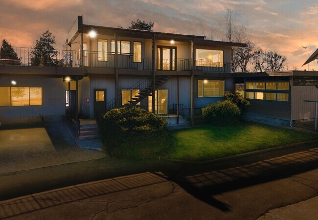
Property Record
Address Unknown, Dexter, OR 97431
Property Detail
Address Unknown
Eugene-Springfield, OR
TL 00300-401
1413614
LANE
Multifamilydwelling
Oregon
RC
300
B and X Area of moderate flood hazard, usually the area between the limits of the 100-year and 500-year floods.
0.43 AC
2025
East Lane County
2025
Portland
0030001005
NEARBY LISTINGS FOR SALE OR LEASE
-
-
View all Dexter listings for sale on LoopNet.com
DEMOGRAPHICS near Address Unknown
1 mile
3 mile
5 mile
2025 Total Population
1,254
4,312
5,867
2030 Population
1,275
4,357
5,889
Pop Growth 2025-2030
+ 1.67%
+ 1.04%
+ 0.37%
Average Age
46
44
45
2025 Total Households
466
1,593
2,179
HH Growth 2025-2030
+ 1.93%
+ 1.13%
+ 0.46%
Median Household Inc
$57,589
$81,550
$84,894
Avg Household Size
2.50
2.60
2.60
2025 Avg HH Vehicles
3.00
3.00
3.00
Median Home Value
$313,861
$391,176
$450,694
Median Year Built
1975
1977
1976
Nearby Places
Map Layers
Map Styles
 Street
 Aerial
Transit
 Traffic
 Biking
Places
Listings with unknown addresses are not visible on the map
- Restaurants
- Banks
- Shops
- Fitness
- Groceries
PUBLIC TRANSPORTATION
AIRPORT
Mahlon Sweet Field
Drive
Walk
Distance
Mahlon Sweet Field
40 min
28.3 mi
SALE & LEASE HISTORY
LISTING DATE
SALE/LEASE

Jun 06, 2023
For Sale
Jun 01, 2023
For Sale
Apr 07, 2023
For Sale
Nearby Properties
Address
Land Use
TOTAL SIZE
Lot Size
Zoning
Address
Land Use
TOTAL SIZE
Lot Size
Zoning
8 AC
PL
Address
Land Use
TOTAL SIZE
Lot Size
Zoning
4.67 AC
PL
Address
Land Use
TOTAL SIZE
Lot Size
Zoning
2,216 SF
21.28 AC
F1
Address
Land Use
TOTAL SIZE
Lot Size
Zoning
Address
Land Use
TOTAL SIZE
Lot Size
Zoning
1.84 AC
PL
Address
Land Use
TOTAL SIZE
Lot Size
Zoning
8,735 SF
5 AC
F1
Address
Land Use
TOTAL SIZE
Lot Size
Zoning
6,311 SF
6.42 AC
F1
Address
Land Use
TOTAL SIZE
Lot Size
Zoning
0.62 AC
RC
Address
Land Use
TOTAL SIZE
Lot Size
Zoning
5,496 SF
4.70 AC
RR5
Address
Land Use
TOTAL SIZE
Lot Size
Zoning
2.05 AC
F1
Address
Land Use
TOTAL SIZE
Lot Size
Zoning
5 AC
F2
Address
Land Use
TOTAL SIZE
Lot Size
Zoning
1.35 AC
RR5
Address
Land Use
TOTAL SIZE
Lot Size
Zoning
1.94 AC
PL
Address
Land Use
TOTAL SIZE
Lot Size
Zoning
6,852 SF
5 AC
F2
Address
Land Use
TOTAL SIZE
Lot Size
Zoning
1.11 AC
RC
Address
Land Use
TOTAL SIZE
Lot Size
Zoning
5,426 SF
5 AC
E40
Address
Land Use
TOTAL SIZE
Lot Size
Zoning
4,512 SF
5 AC
F1
Address
Land Use
TOTAL SIZE
Lot Size
Zoning
4,488 SF
5 AC
F2
Address
Land Use
TOTAL SIZE
Lot Size
Zoning
0.88 AC
PL
Address
Land Use
TOTAL SIZE
Lot Size
Zoning
3,975 SF
6 AC
E40
Address
Land Use
TOTAL SIZE
Lot Size
Zoning
3,987 SF
5 AC
E40
Address
Land Use
TOTAL SIZE
Lot Size
Zoning
7,546 SF
5 AC
Address
Land Use
TOTAL SIZE
Lot Size
Zoning
1.73 AC
F2
Address
Land Use
TOTAL SIZE
Lot Size
Zoning
1.60 AC
PL
Address
Land Use
TOTAL SIZE
Lot Size
Zoning
3,901 SF
5 AC
F1
Address
Land Use
TOTAL SIZE
Lot Size
Zoning
1.16 AC
F1
Address
Land Use
TOTAL SIZE
Lot Size
Zoning
3,741 SF
5 AC
E40
Address
Land Use
TOTAL SIZE
Lot Size
Zoning
197.54 AC
E30
Address
Land Use
TOTAL SIZE
Lot Size
Zoning
4,552 SF
32.93 AC
E40
Address
Land Use
TOTAL SIZE
Lot Size
Zoning
1 AC
RC
The World's #1 Commercial Real Estate Marketplace
Connect with us
© 2026 CoStar Group
The information above has been obtained from sources believed reliable. While we do not doubt its accuracy we have not verified it and make no guarantee, warranty or representation about it. It is your responsibility to independently confirm its accuracy and completeness. Any projections, opinions, assumptions, or estimates used are for example only and do not represent the current or future performance of the property. The value of this transaction to you depends on tax and other factors which should be evaluated by your tax, financial, and legal advisors. You and your advisors should conduct a careful, independent investigation of the property to determine to your satisfaction the suitability of the property for your needs.