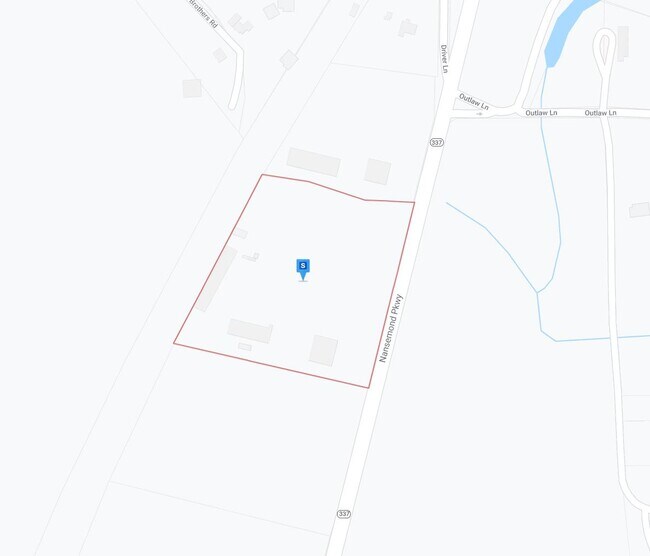
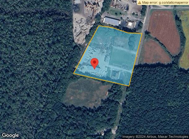
Property Record
3909 Nansemond Pky, Suffolk, VA 23435
NEARBY LISTINGS FOR SALE OR LEASE
Property Detail
3909 Nansemond Pky
304362900
Sleepy Hole Borough
Commercialnec
L 3 RICHARD BENNET TRUST
X
Suffolk City
51093C0300E
Virginia
2025
6.01 AC
2025
North Suffolk
075502
Hampton Roads
4,100 SF
Virginia Beach-Norfolk-Newport News, VA-NC
DEMOGRAPHICS near 3909 Nansemond Pky
1 Mile
3 Mile
5 Mile
2024 Total Population
1,204
12,880
45,689
2029 Population
1,327
14,249
50,134
Pop Growth 2024-2029
+ 10.22%
+ 10.63%
+ 9.73%
Average Age
40
38
38
2024 Total Households
410
4,355
16,497
HH Growth 2024-2029
+ 10.49%
+ 10.91%
+ 9.99%
Median Household Inc
$113,319
$122,015
$109,311
Avg Household Size
2.90
2.90
2.70
2024 Avg HH Vehicles
3.00
3.00
2.00
Median Home Value
$356,481
$341,691
$331,682
Median Year Built
2000
2002
2002
Nearby Places
Map Layers
Map Styles
 Street
 Aerial
- Restaurants
- Banks
- Shops
- Fitness
- Groceries
PUBLIC TRANSPORTATION
AIRPORT
Norfolk International
DRIVE
WALK
Distance
Norfolk International
37 min
22.8 mi
Newport News/Williamsburg International
DRIVE
WALK
Distance
Newport News/Williamsburg International
45 min
31.6 mi
Freight Ports
Virginia Port Authority - Portsmouth
DRIVE
WALK
Distance
Virginia Port Authority - Portsmouth
26 min
14.5 mi
Nearby Properties
Address
Land Use
TOTAL SIZE
Lot Size
Zoning
Address
Land Use
TOTAL SIZE
Lot Size
Zoning
3,817,119 SF
87.24 AC
HEAVY INDU
Address
Land Use
TOTAL SIZE
Lot Size
Zoning
637,266 SF
73.24 AC
PUD: PLANN
Address
Land Use
TOTAL SIZE
Lot Size
Zoning
359,146 SF
16.95 AC
RMF1: MULT
Address
Land Use
TOTAL SIZE
Lot Size
Zoning
88,346 SF
31.49 AC
HEAVY INDU
Address
Land Use
TOTAL SIZE
Lot Size
Zoning
77 SF
49.11 AC
RES LOW-ME
Address
Land Use
TOTAL SIZE
Lot Size
Zoning
71,769 SF
20.80 AC
RES LOW-ME
Address
Land Use
TOTAL SIZE
Lot Size
Zoning
150,000 SF
21.52 AC
HEAVY INDU
Address
Land Use
TOTAL SIZE
Lot Size
Zoning
85,824 SF
3.18 AC
LIGHT INDU
Address
Land Use
TOTAL SIZE
Lot Size
Zoning
1,050 SF
10.33 AC
LIGHT INDU
Address
Land Use
TOTAL SIZE
Lot Size
Zoning
101,286 SF
136.57 AC
CONSERVATI
Address
Land Use
TOTAL SIZE
Lot Size
Zoning
64,192 SF
15.67 AC
HEAVY INDU
Address
Land Use
TOTAL SIZE
Lot Size
Zoning
271.20 AC
RURAL RESI
Address
Land Use
TOTAL SIZE
Lot Size
Zoning
58,439 SF
14.86 AC
RURAL ESTA
Address
Land Use
TOTAL SIZE
Lot Size
Zoning
912 SF
28.50 AC
RES LOW-ME
Address
Land Use
TOTAL SIZE
Lot Size
Zoning
20,973 SF
6.87 AC
LIGHT INDU
Address
Land Use
TOTAL SIZE
Lot Size
Zoning
51,420 SF
9.59 AC
HEAVY INDU
Address
Land Use
TOTAL SIZE
Lot Size
Zoning
6,338 SF
192.62 AC
CONSERVATI
Address
Land Use
TOTAL SIZE
Lot Size
Zoning
136 AC
CONSERVATI
Address
Land Use
TOTAL SIZE
Lot Size
Zoning
59,804 SF
9.70 AC
RES LOW-ME
Address
Land Use
TOTAL SIZE
Lot Size
Zoning
30.31 AC
HEAVY INDU
Address
Land Use
TOTAL SIZE
Lot Size
Zoning
23,376 SF
6.47 AC
HEAVY INDU
Address
Land Use
TOTAL SIZE
Lot Size
Zoning
28,200 SF
6.54 AC
HEAVY INDU
The World's #1 Commercial Real Estate Marketplace
Connect with us
© 2026 CoStar Group
The information above has been obtained from sources believed reliable. While we do not doubt its accuracy we have not verified it and make no guarantee, warranty or representation about it. It is your responsibility to independently confirm its accuracy and completeness. Any projections, opinions, assumptions, or estimates used are for example only and do not represent the current or future performance of the property. The value of this transaction to you depends on tax and other factors which should be evaluated by your tax, financial, and legal advisors. You and your advisors should conduct a careful, independent investigation of the property to determine to your satisfaction the suitability of the property for your needs.