Property Record
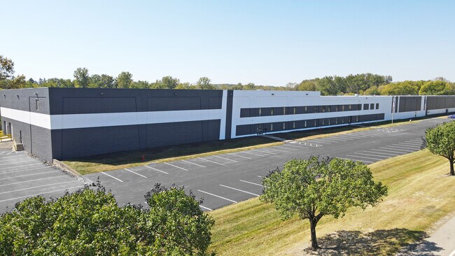
3909 Research Blvd, Beavercreek, OH 45430

Current Lease Availabilities
NEARBY LISTINGS FOR SALE OR LEASE
Property Detail
3909 Research Blvd
B42-0002-0013-0-0064-00
7/2/2002 DP&L EASEMENT GRANGE HALL RD
Industrialgeneral
Greene
AE
Ohio
39057C0102E
6.47 AC
2024
East Dayton
2024
Cincinnati/Dayton
210300
Dayton, OH
68,145 SF
DEMOGRAPHICS near 3909 Research Blvd
1 Mile
3 Mile
5 Mile
2024 Total Population
3,254
60,684
179,776
2029 Population
3,294
61,021
181,004
Pop Growth 2024-2029
+ 1.23%
+ 0.56%
+ 0.68%
Average Age
41
42
39
2024 Total Households
1,228
25,577
75,525
HH Growth 2024-2029
+ 1.14%
+ 0.42%
+ 0.62%
Median Household Inc
$95,662
$81,139
$65,521
Avg Household Size
2.60
2.30
2.30
2024 Avg HH Vehicles
2.00
2.00
2.00
Median Home Value
$174,324
$180,026
$170,812
Median Year Built
1957
1966
1962
Nearby Places
Map Layers
Map Styles
 Street
 Aerial
- Restaurants
- Banks
- Shops
- Fitness
- Groceries
PUBLIC TRANSPORTATION
AIRPORT
James M Cox Dayton International
DRIVE
WALK
Distance
James M Cox Dayton International
33 min
19.3 mi
Freight Ports
Port of Toledo
DRIVE
WALK
Distance
Port of Toledo
189 min
159.5 mi
Nearby Properties
Address
Land Use
TOTAL SIZE
Lot Size
Zoning
Address
Land Use
TOTAL SIZE
Lot Size
Zoning
552,803 SF
29.77 AC
CPUD882
Address
Land Use
TOTAL SIZE
Lot Size
Zoning
752,874 SF
74.85 AC
Address
Land Use
TOTAL SIZE
Lot Size
Zoning
175,938 SF
49.33 AC
Address
Land Use
TOTAL SIZE
Lot Size
Zoning
53.48 AC
RP1
Address
Land Use
TOTAL SIZE
Lot Size
Zoning
1,951 SF
56.54 AC
Address
Land Use
TOTAL SIZE
Lot Size
Zoning
240,090 SF
1.93 AC
MXPUD02
Address
Land Use
TOTAL SIZE
Lot Size
Zoning
49,316 SF
30.39 AC
CPUD933
Address
Land Use
TOTAL SIZE
Lot Size
Zoning
130,247 SF
14.12 AC
Address
Land Use
TOTAL SIZE
Lot Size
Zoning
Address
Land Use
TOTAL SIZE
Lot Size
Zoning
3,243 SF
22.88 AC
R-PUD 97-3
Address
Land Use
TOTAL SIZE
Lot Size
Zoning
88,522 SF
12.96 AC
Address
Land Use
TOTAL SIZE
Lot Size
Zoning
145,500 SF
32.62 AC
A1
Address
Land Use
TOTAL SIZE
Lot Size
Zoning
46,796 SF
53.05 AC
RPUD038
Address
Land Use
TOTAL SIZE
Lot Size
Zoning
32.30 AC
Address
Land Use
TOTAL SIZE
Lot Size
Zoning
47,424 SF
22.77 AC
RPUD917
Address
Land Use
TOTAL SIZE
Lot Size
Zoning
1,008 SF
7 AC
R1A
Address
Land Use
TOTAL SIZE
Lot Size
Zoning
109,680 SF
32.24 AC
R4
Address
Land Use
TOTAL SIZE
Lot Size
Zoning
45,522 SF
10.22 AC
Address
Land Use
TOTAL SIZE
Lot Size
Zoning
94,608 SF
7.44 AC
Address
Land Use
TOTAL SIZE
Lot Size
Zoning
130,766 SF
1.68 AC
Address
Land Use
TOTAL SIZE
Lot Size
Zoning
152,844 SF
14.80 AC
Address
Land Use
TOTAL SIZE
Lot Size
Zoning
121,392 SF
12.47 AC
Address
Land Use
TOTAL SIZE
Lot Size
Zoning
76,038 SF
12.59 AC
CPUD971
Address
Land Use
TOTAL SIZE
Lot Size
Zoning
89,176 SF
17.52 AC
Address
Land Use
TOTAL SIZE
Lot Size
Zoning
108,274 SF
25.09 AC
RPUD427
Address
Land Use
TOTAL SIZE
Lot Size
Zoning
100,450 SF
1.66 AC
MXPUD02
Address
Land Use
TOTAL SIZE
Lot Size
Zoning
45,954 SF
9.46 AC
Address
Land Use
TOTAL SIZE
Lot Size
Zoning
148,309 SF
1.50 AC
MXPUD02
Address
Land Use
TOTAL SIZE
Lot Size
Zoning
309,331 SF
36 AC
Address
Land Use
TOTAL SIZE
Lot Size
Zoning
9,216 SF
16.77 AC
RPUD891
The World's #1 Commercial Real Estate Marketplace
Connect with us
© 2025 CoStar Group
The information above has been obtained from sources believed reliable. While we do not doubt its accuracy we have not verified it and make no guarantee, warranty or representation about it. It is your responsibility to independently confirm its accuracy and completeness. Any projections, opinions, assumptions, or estimates used are for example only and do not represent the current or future performance of the property. The value of this transaction to you depends on tax and other factors which should be evaluated by your tax, financial, and legal advisors. You and your advisors should conduct a careful, independent investigation of the property to determine to your satisfaction the suitability of the property for your needs.