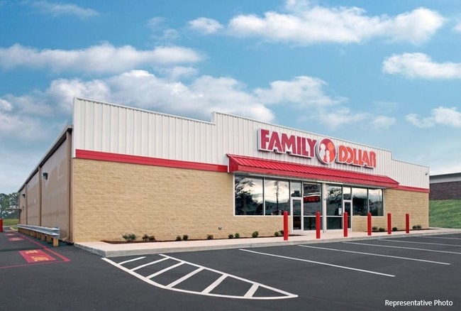
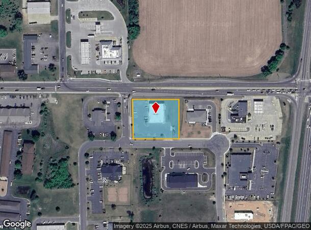
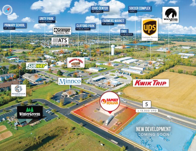
Property Record
391 Cherrywood St Ne, Isanti, MN 55040
NEARBY LISTINGS FOR SALE OR LEASE
-
-
View all Isanti listings for sale on LoopNet.com
Property Detail
391 Cherrywood St Ne
Minneapolis-St. Paul-Bloomington, MN-WI
Anlauf Commercial Park
16.126.0010
SUBDIVISIONNAME ANLAUF COMMERCIAL PARK LOT 001 BLOCK 001 SUBDIVISIONCD 16126
Multipleuses
Isanti
X
Minnesota
27003C0100E
1
2025
1.20 AC
2025
Isanti County
130502
Minneapolis/St Paul
8,320 SF
DEMOGRAPHICS near 391 Cherrywood St Ne
1 Mile
3 Mile
5 Mile
2024 Total Population
4,960
9,952
19,847
2029 Population
5,572
11,162
22,261
Pop Growth 2024-2029
+ 12.34%
+ 12.16%
+ 12.16%
Average Age
35
36
38
2024 Total Households
1,794
3,579
7,373
HH Growth 2024-2029
+ 12.26%
+ 12.13%
+ 12.15%
Median Household Inc
$78,846
$78,350
$81,349
Avg Household Size
2.80
2.80
2.70
2024 Avg HH Vehicles
2.00
2.00
2.00
Median Home Value
$227,975
$232,925
$243,157
Median Year Built
2001
2001
1997
Nearby Places
Map Layers
Map Styles
 Street
 Aerial
- Restaurants
- Banks
- Shops
- Fitness
- Groceries
SALE & LEASE HISTORY
LISTING DATE
SALE/LEASE

Sep 23, 2016
For Sale
Sep 23, 2016
For Sale
Nov 03, 2021
For Sale
Mar 23, 2017
For Sale
Nearby Properties
Address
Land Use
TOTAL SIZE
Lot Size
Zoning
Address
Land Use
TOTAL SIZE
Lot Size
Zoning
102,242 SF
34.18 AC
SR
Address
Land Use
TOTAL SIZE
Lot Size
Zoning
95,878 SF
20 AC
Address
Land Use
TOTAL SIZE
Lot Size
Zoning
32,323 SF
28.95 AC
Address
Land Use
TOTAL SIZE
Lot Size
Zoning
11,100 SF
5.16 AC
Address
Land Use
TOTAL SIZE
Lot Size
Zoning
53,320 SF
5.93 AC
Address
Land Use
TOTAL SIZE
Lot Size
Zoning
16,264 SF
7.95 AC
Address
Land Use
TOTAL SIZE
Lot Size
Zoning
21,120 SF
10.90 AC
Address
Land Use
TOTAL SIZE
Lot Size
Zoning
11,010 SF
1.91 AC
Address
Land Use
TOTAL SIZE
Lot Size
Zoning
80,761 SF
0.91 AC
Address
Land Use
TOTAL SIZE
Lot Size
Zoning
71,400 SF
3.62 AC
Address
Land Use
TOTAL SIZE
Lot Size
Zoning
13,616 SF
1.71 AC
Address
Land Use
TOTAL SIZE
Lot Size
Zoning
13,616 SF
1.72 AC
Address
Land Use
TOTAL SIZE
Lot Size
Zoning
12,090 SF
1.37 AC
Address
Land Use
TOTAL SIZE
Lot Size
Zoning
18,416 SF
2 AC
Address
Land Use
TOTAL SIZE
Lot Size
Zoning
7,176 SF
4.02 AC
Address
Land Use
TOTAL SIZE
Lot Size
Zoning
6,137 SF
2.16 AC
Address
Land Use
TOTAL SIZE
Lot Size
Zoning
25,200 SF
5.72 AC
B
Address
Land Use
TOTAL SIZE
Lot Size
Zoning
22,080 SF
1.74 AC
Address
Land Use
TOTAL SIZE
Lot Size
Zoning
18,300 SF
3 AC
Address
Land Use
TOTAL SIZE
Lot Size
Zoning
4,800 SF
4.54 AC
G
Address
Land Use
TOTAL SIZE
Lot Size
Zoning
45,500 SF
4 AC
Address
Land Use
TOTAL SIZE
Lot Size
Zoning
11,200 SF
5.72 AC
B
Address
Land Use
TOTAL SIZE
Lot Size
Zoning
17,920 SF
3.63 AC
Address
Land Use
TOTAL SIZE
Lot Size
Zoning
16,640 SF
1 AC
Address
Land Use
TOTAL SIZE
Lot Size
Zoning
2,912 SF
2.64 AC
Address
Land Use
TOTAL SIZE
Lot Size
Zoning
10,066 SF
8.40 AC
Address
Land Use
TOTAL SIZE
Lot Size
Zoning
11,676 SF
11.80 AC
Address
Land Use
TOTAL SIZE
Lot Size
Zoning
10,976 SF
1.82 AC
The World's #1 Commercial Real Estate Marketplace
Connect with us
© 2025 CoStar Group
The information above has been obtained from sources believed reliable. While we do not doubt its accuracy we have not verified it and make no guarantee, warranty or representation about it. It is your responsibility to independently confirm its accuracy and completeness. Any projections, opinions, assumptions, or estimates used are for example only and do not represent the current or future performance of the property. The value of this transaction to you depends on tax and other factors which should be evaluated by your tax, financial, and legal advisors. You and your advisors should conduct a careful, independent investigation of the property to determine to your satisfaction the suitability of the property for your needs.