Property Record
391 E Main St, Andover, OH 44003
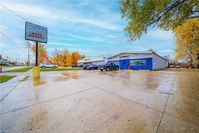

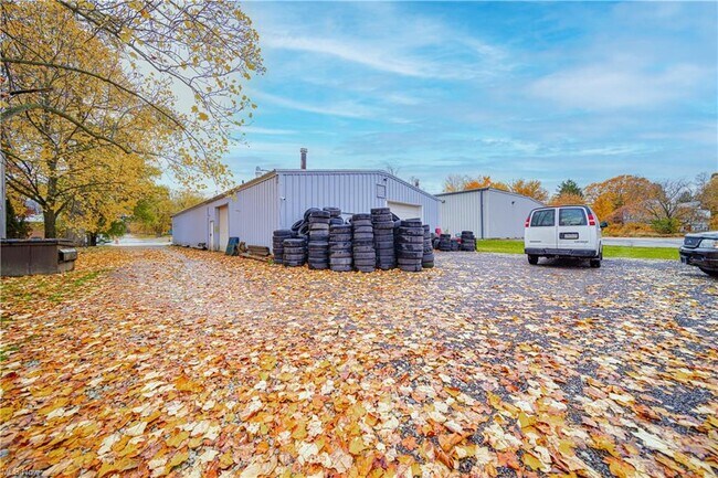
Property Detail
391 E Main St
Cleveland-Elyria, OH
25 S M
020132012900
Ashtabula
Storebuilding
Ohio
B and X Area of moderate flood hazard, usually the area between the limits of the 100-year and 500-year floods.
25
2024
0.50 AC
2024
Ashtabula County
001304
Cleveland
4,000 SF
NEARBY LISTINGS FOR SALE OR LEASE
-
-
View all Andover listings for sale on LoopNet.com
DEMOGRAPHICS near 391 E Main St
1 mile
3 mile
5 mile
2025 Total Population
1,052
2,135
5,619
2030 Population
999
2,039
5,678
Pop Growth 2025-2030
(5.04%)
(4.50%)
+ 1.05%
Average Age
45
46
48
2025 Total Households
421
877
2,497
HH Growth 2025-2030
(5.46%)
(4.79%)
+ 1.44%
Median Household Inc
$56,249
$57,095
$57,690
Avg Household Size
2.30
2.30
2.20
2025 Avg HH Vehicles
2.00
2.00
2.00
Median Home Value
$125,704
$135,370
$144,512
Median Year Built
1973
1975
1976
Nearby Places
Map Layers
Map Styles
 Street
 Aerial
Transit
 Traffic
 Biking
Places
Listings with unknown addresses are not visible on the map
- Restaurants
- Banks
- Shops
- Fitness
- Groceries
SALE & LEASE HISTORY
LISTING DATE
SALE/LEASE

Nov 07, 2022
For Sale
Dec 21, 2023
For Sale
Aug 23, 2022
For Sale
Nearby Properties
Address
Land Use
TOTAL SIZE
Lot Size
Zoning
Address
Land Use
TOTAL SIZE
Lot Size
Zoning
291,039 SF
51.97 AC
Address
Land Use
TOTAL SIZE
Lot Size
Zoning
Address
Land Use
TOTAL SIZE
Lot Size
Zoning
Address
Land Use
TOTAL SIZE
Lot Size
Zoning
Address
Land Use
TOTAL SIZE
Lot Size
Zoning
747.20 AC
Address
Land Use
TOTAL SIZE
Lot Size
Zoning
725.25 AC
Address
Land Use
TOTAL SIZE
Lot Size
Zoning
712.28 AC
Address
Land Use
TOTAL SIZE
Lot Size
Zoning
Address
Land Use
TOTAL SIZE
Lot Size
Zoning
36,821 SF
3.37 AC
Address
Land Use
TOTAL SIZE
Lot Size
Zoning
Address
Land Use
TOTAL SIZE
Lot Size
Zoning
Address
Land Use
TOTAL SIZE
Lot Size
Zoning
24,714 SF
0.31 AC
Address
Land Use
TOTAL SIZE
Lot Size
Zoning
27,360 SF
3.37 AC
Address
Land Use
TOTAL SIZE
Lot Size
Zoning
15,139 SF
5.47 AC
Address
Land Use
TOTAL SIZE
Lot Size
Zoning
49.49 AC
Address
Land Use
TOTAL SIZE
Lot Size
Zoning
68,025 SF
15.74 AC
Address
Land Use
TOTAL SIZE
Lot Size
Zoning
1.81 AC
Address
Land Use
TOTAL SIZE
Lot Size
Zoning
23,136 SF
2.66 AC
Address
Land Use
TOTAL SIZE
Lot Size
Zoning
27,037 SF
1.87 AC
Address
Land Use
TOTAL SIZE
Lot Size
Zoning
79,300 SF
7.02 AC
Address
Land Use
TOTAL SIZE
Lot Size
Zoning
24,900 SF
7.23 AC
Address
Land Use
TOTAL SIZE
Lot Size
Zoning
3,274 SF
153.07 AC
Address
Land Use
TOTAL SIZE
Lot Size
Zoning
8,092 SF
82.49 AC
Address
Land Use
TOTAL SIZE
Lot Size
Zoning
5,137 SF
26.49 AC
Address
Land Use
TOTAL SIZE
Lot Size
Zoning
19,188 SF
2.07 AC
Address
Land Use
TOTAL SIZE
Lot Size
Zoning
3,824 SF
49.56 AC
Address
Land Use
TOTAL SIZE
Lot Size
Zoning
3,240 SF
121.65 AC
Address
Land Use
TOTAL SIZE
Lot Size
Zoning
1,400 SF
1.72 AC
Address
Land Use
TOTAL SIZE
Lot Size
Zoning
9,078 SF
0.34 AC
Address
Land Use
TOTAL SIZE
Lot Size
Zoning
5,786 SF
46 AC
The World's #1 Commercial Real Estate Marketplace
Connect with us
© 2026 CoStar Group
The information above has been obtained from sources believed reliable. While we do not doubt its accuracy we have not verified it and make no guarantee, warranty or representation about it. It is your responsibility to independently confirm its accuracy and completeness. Any projections, opinions, assumptions, or estimates used are for example only and do not represent the current or future performance of the property. The value of this transaction to you depends on tax and other factors which should be evaluated by your tax, financial, and legal advisors. You and your advisors should conduct a careful, independent investigation of the property to determine to your satisfaction the suitability of the property for your needs.