Property Record
3910-3920 Oakwood Ave, Los Angeles, CA 90004

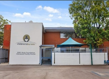

This Property Is For Sale
Current Lease Availabilities
NEARBY LISTINGS FOR SALE OR LEASE
Property Detail
3910-3920 Oakwood Ave
Los Angeles-Long Beach-Glendale, CA
Barrows Addition
5520-019-005
BARROWS ADD TO THE CITY OF LOS ANGELES E 70 FT OF LOT 7 BLK A
Residentialacreage
Los Angeles
X
California
06037C1610F
7
2024
0.10 AC
2025
East Hollywood/Silver Lake
192620
Los Angeles
DEMOGRAPHICS near 3910-3920 Oakwood Ave
1 Mile
3 Mile
5 Mile
2024 Total Population
95,775
570,291
1,105,268
2029 Population
93,497
558,792
1,077,338
Pop Growth 2024-2029
(2.38%)
(2.02%)
(2.53%)
Average Age
38
39
39
2024 Total Households
38,392
242,462
457,227
HH Growth 2024-2029
(2.68%)
(2.02%)
(2.49%)
Median Household Inc
$53,659
$55,744
$59,868
Avg Household Size
2.40
2.20
2.30
2024 Avg HH Vehicles
1.00
1.00
1.00
Median Home Value
$902,808
$1,039,293
$974,801
Median Year Built
1963
1963
1960
Nearby Places
Map Layers
Map Styles
 Street
 Aerial
- Restaurants
- Banks
- Shops
- Fitness
- Groceries
PUBLIC TRANSPORTATION
TRANSIT/SUBWAY
Vermont/Beverly Station (Red Line - Los Angeles County Metropolitan Transportation Authority (Metro))
DRIVE
WALK
Distance
Vermont/Beverly Station (Red Line - Los Angeles County Metropolitan Transportation Authority (Metro))
0 min
2 min
0.1 mi
Vermont/Santa Monica Station (Red Line - Los Angeles County Metropolitan Transportation Authority (Metro))
DRIVE
WALK
Distance
Vermont/Santa Monica Station (Red Line - Los Angeles County Metropolitan Transportation Authority (Metro))
1 min
17 min
0.9 mi
COMMUTER RAIL
Los Angeles (Coast Starlight - Amtrak, Pacific Surfliner - Amtrak, Southwest Chief - Amtrak, Texas Eagle - Amtrak)
DRIVE
WALK
Distance
Los Angeles (Coast Starlight - Amtrak, Pacific Surfliner - Amtrak, Southwest Chief - Amtrak, Texas Eagle - Amtrak)
6 min
3.8 mi
Union Station (91 Line - Southern California Regional Rail Authority (Metrolink), Antelope Valley Line - Southern California Regional Rail Authority (Metrolink), Orange County Line - Southern California Regional Rail Authority (Metrolink), Riverside Line - Southern California Regional Rail Authority (Metrolink), San Bernardino Line - Southern California Regional Rail Authority (Metrolink), Ventura County Line - Southern California Regional Rail Authority (Metrolink))
DRIVE
WALK
Distance
Union Station (91 Line - Southern California Regional Rail Authority (Metrolink), Antelope Valley Line - Southern California Regional Rail Authority (Metrolink), Orange County Line - Southern California Regional Rail Authority (Metrolink), Riverside Line - Southern California Regional Rail Authority (Metrolink), San Bernardino Line - Southern California Regional Rail Authority (Metrolink), Ventura County Line - Southern California Regional Rail Authority (Metrolink))
8 min
4.0 mi
AIRPORT
Bob Hope
DRIVE
WALK
Distance
Bob Hope
19 min
11.4 mi
Los Angeles International
DRIVE
WALK
Distance
Los Angeles International
26 min
15.0 mi
Long Beach (Daugherty Field)
DRIVE
WALK
Distance
Long Beach (Daugherty Field)
34 min
24.9 mi
Freight Ports
Port of Long Beach
DRIVE
WALK
Distance
Port of Long Beach
37 min
26.7 mi
Nearby Properties
Address
Land Use
TOTAL SIZE
Lot Size
Zoning
Address
Land Use
TOTAL SIZE
Lot Size
Zoning
2,832,748 SF
4.20 AC
LAC2
Address
Land Use
TOTAL SIZE
Lot Size
Zoning
930,249 SF
7.39 AC
LAC2
Address
Land Use
TOTAL SIZE
Lot Size
Zoning
1,392,719 SF
4.22 AC
LAC4
Address
Land Use
TOTAL SIZE
Lot Size
Zoning
2,001,034 SF
2.71 AC
LAC2
Address
Land Use
TOTAL SIZE
Lot Size
Zoning
108,464 SF
9.17 AC
LALASED
Address
Land Use
TOTAL SIZE
Lot Size
Zoning
969,264 SF
0.94 AC
LAC2
Address
Land Use
TOTAL SIZE
Lot Size
Zoning
717,065 SF
0.99 AC
LAC2
Address
Land Use
TOTAL SIZE
Lot Size
Zoning
1,039,642 SF
2.84 AC
LAC2
Address
Land Use
TOTAL SIZE
Lot Size
Zoning
1,486,375 SF
3.77 AC
LAR5
Address
Land Use
TOTAL SIZE
Lot Size
Zoning
1,457,208 SF
1.39 AC
LAC2
Address
Land Use
TOTAL SIZE
Lot Size
Zoning
949,529 SF
1.50 AC
LAC2
Address
Land Use
TOTAL SIZE
Lot Size
Zoning
200,811 SF
4.59 AC
LALASED
Address
Land Use
TOTAL SIZE
Lot Size
Zoning
764,804 SF
1.48 AC
Address
Land Use
TOTAL SIZE
Lot Size
Zoning
634,863 SF
2.97 AC
LAC2-4D
Address
Land Use
TOTAL SIZE
Lot Size
Zoning
709,584 SF
1.80 AC
LAPB
Address
Land Use
TOTAL SIZE
Lot Size
Zoning
1,346,113 SF
1.17 AC
LAC5
Address
Land Use
TOTAL SIZE
Lot Size
Zoning
738,975 SF
2.71 AC
LAC2
Address
Land Use
TOTAL SIZE
Lot Size
Zoning
1,094,768 SF
0.73 AC
LAC2
Address
Land Use
TOTAL SIZE
Lot Size
Zoning
161,046 SF
6.88 AC
LAM1
Address
Land Use
TOTAL SIZE
Lot Size
Zoning
705,234 SF
1.83 AC
LAC2
Address
Land Use
TOTAL SIZE
Lot Size
Zoning
966,466 SF
3.99 AC
LAC2
Address
Land Use
TOTAL SIZE
Lot Size
Zoning
773,409 SF
1.39 AC
LAC4
Address
Land Use
TOTAL SIZE
Lot Size
Zoning
1,005,477 SF
1.36 AC
LAC4
Address
Land Use
TOTAL SIZE
Lot Size
Zoning
67,126 SF
48.09 AC
LAM1
Address
Land Use
TOTAL SIZE
Lot Size
Zoning
641,453 SF
2.93 AC
LAC4
Address
Land Use
TOTAL SIZE
Lot Size
Zoning
497,377 SF
3.29 AC
LAC4
Address
Land Use
TOTAL SIZE
Lot Size
Zoning
1,207,589 SF
1.01 AC
LAC2
Address
Land Use
TOTAL SIZE
Lot Size
Zoning
651,289 SF
3.79 AC
LACW
Address
Land Use
TOTAL SIZE
Lot Size
Zoning
1.28 AC
LAC2
Address
Land Use
TOTAL SIZE
Lot Size
Zoning
724,958 SF
5.88 AC
LAC2
The World's #1 Commercial Real Estate Marketplace
Connect with us
© 2026 CoStar Group
The information above has been obtained from sources believed reliable. While we do not doubt its accuracy we have not verified it and make no guarantee, warranty or representation about it. It is your responsibility to independently confirm its accuracy and completeness. Any projections, opinions, assumptions, or estimates used are for example only and do not represent the current or future performance of the property. The value of this transaction to you depends on tax and other factors which should be evaluated by your tax, financial, and legal advisors. You and your advisors should conduct a careful, independent investigation of the property to determine to your satisfaction the suitability of the property for your needs.