Property Record
3910 Gattis School Rd, Round Rock, TX 78664

NEARBY LISTINGS FOR SALE OR LEASE
Property Detail
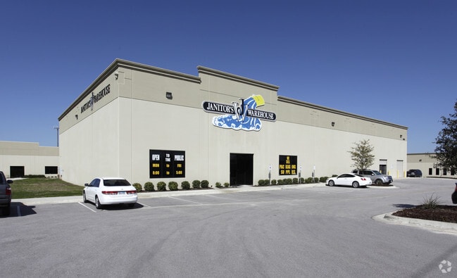
3910 Gattis School Rd
Austin-Round Rock-San Marcos, TX
Forest Commons Business Park
R491983
S9568 - FOREST COMMONS BUSINESS PARK, LOT 2, ACRES 1.2979
Commercialnec
Williamson
X
Texas
48491C0675F
2
2024
1.30 AC
2025
Round Rock
020814
Austin
17,000 SF
DEMOGRAPHICS near 3910 Gattis School Rd
1 Mile
3 Mile
5 Mile
2024 Total Population
13,381
92,234
241,313
2029 Population
16,143
109,773
288,370
Pop Growth 2024-2029
+ 20.64%
+ 19.02%
+ 19.50%
Average Age
37
36
36
2024 Total Households
4,198
32,087
85,023
HH Growth 2024-2029
+ 21.06%
+ 19.76%
+ 20.26%
Median Household Inc
$117,846
$105,131
$96,504
Avg Household Size
3.10
2.80
2.80
2024 Avg HH Vehicles
2.00
2.00
2.00
Median Home Value
$398,911
$348,431
$329,209
Median Year Built
2004
2007
2006
Nearby Places
Map Layers
Map Styles
 Street
 Aerial
- Restaurants
- Banks
- Shops
- Fitness
- Groceries
PUBLIC TRANSPORTATION
AIRPORT
Austin-Bergstrom International
DRIVE
WALK
Distance
Austin-Bergstrom International
39 min
29.6 mi
SALE & LEASE HISTORY
LISTING DATE
SALE/LEASE

May 02, 2024
For Lease
Nearby Properties
Address
Land Use
TOTAL SIZE
Lot Size
Zoning
Address
Land Use
TOTAL SIZE
Lot Size
Zoning
1,240,638 SF
171.60 AC
Address
Land Use
TOTAL SIZE
Lot Size
Zoning
422,682 SF
95.18 AC
Address
Land Use
TOTAL SIZE
Lot Size
Zoning
475,624 SF
64.73 AC
Address
Land Use
TOTAL SIZE
Lot Size
Zoning
445,321 SF
12.52 AC
Address
Land Use
TOTAL SIZE
Lot Size
Zoning
400,695 SF
21.02 AC
Address
Land Use
TOTAL SIZE
Lot Size
Zoning
273,462 SF
47.12 AC
Address
Land Use
TOTAL SIZE
Lot Size
Zoning
541,124 SF
60.17 AC
Address
Land Use
TOTAL SIZE
Lot Size
Zoning
425,891 SF
20.85 AC
Address
Land Use
TOTAL SIZE
Lot Size
Zoning
361,440 SF
19.35 AC
Address
Land Use
TOTAL SIZE
Lot Size
Zoning
377,239 SF
16.95 AC
Address
Land Use
TOTAL SIZE
Lot Size
Zoning
618,605 SF
14.11 AC
PUD
Address
Land Use
TOTAL SIZE
Lot Size
Zoning
326,015 SF
11.11 AC
Address
Land Use
TOTAL SIZE
Lot Size
Zoning
201,200 SF
9.48 AC
Address
Land Use
TOTAL SIZE
Lot Size
Zoning
275,550 SF
10.50 AC
Address
Land Use
TOTAL SIZE
Lot Size
Zoning
409,416 SF
22.65 AC
Address
Land Use
TOTAL SIZE
Lot Size
Zoning
344,341 SF
19.19 AC
PUD
Address
Land Use
TOTAL SIZE
Lot Size
Zoning
252,482 SF
17.43 AC
Address
Land Use
TOTAL SIZE
Lot Size
Zoning
336,672 SF
15.09 AC
Address
Land Use
TOTAL SIZE
Lot Size
Zoning
252,984 SF
16.62 AC
Address
Land Use
TOTAL SIZE
Lot Size
Zoning
220,792 SF
11.31 AC
Address
Land Use
TOTAL SIZE
Lot Size
Zoning
276,364 SF
12.33 AC
PUD
Address
Land Use
TOTAL SIZE
Lot Size
Zoning
212,850 SF
11.26 AC
Address
Land Use
TOTAL SIZE
Lot Size
Zoning
217,260 SF
15.27 AC
Address
Land Use
TOTAL SIZE
Lot Size
Zoning
183,074 SF
21.48 AC
Address
Land Use
TOTAL SIZE
Lot Size
Zoning
200,126 SF
18.41 AC
PUD
Address
Land Use
TOTAL SIZE
Lot Size
Zoning
308,759 SF
13.93 AC
Address
Land Use
TOTAL SIZE
Lot Size
Zoning
205,584 SF
14.70 AC
Address
Land Use
TOTAL SIZE
Lot Size
Zoning
165,534 SF
26.91 AC
Address
Land Use
TOTAL SIZE
Lot Size
Zoning
192,814 SF
13.22 AC
PUD
Address
Land Use
TOTAL SIZE
Lot Size
Zoning
160,875 SF
10 AC
The World's #1 Commercial Real Estate Marketplace
Connect with us
© 2026 CoStar Group
The information above has been obtained from sources believed reliable. While we do not doubt its accuracy we have not verified it and make no guarantee, warranty or representation about it. It is your responsibility to independently confirm its accuracy and completeness. Any projections, opinions, assumptions, or estimates used are for example only and do not represent the current or future performance of the property. The value of this transaction to you depends on tax and other factors which should be evaluated by your tax, financial, and legal advisors. You and your advisors should conduct a careful, independent investigation of the property to determine to your satisfaction the suitability of the property for your needs.