Property Record
3910 Groves Rd, Columbus, OH 43232
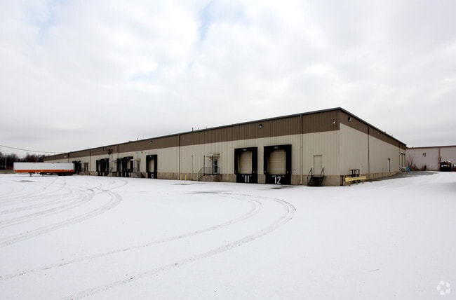

Property Detail
3910 Groves Rd
Columbus, OH
COURTRIGHT RD R21 T12 S20 4.038 ACRES
010-057211
Franklin
Warehouse
Ohio
2024
4.04 AC
2025
I-70 East Corridor
009325
Columbus
74,400 SF
NEARBY LISTINGS FOR SALE OR LEASE
DEMOGRAPHICS near 3910 Groves Rd
1 mile
3 mile
5 mile
2025 Total Population
17,717
118,362
260,406
2030 Population
18,137
122,170
270,230
Pop Growth 2025-2030
+ 2.37%
+ 3.22%
+ 3.77%
Average Age
37
38
38
2025 Total Households
7,359
48,422
107,966
HH Growth 2025-2030
+ 2.58%
+ 3.50%
+ 3.97%
Median Household Inc
$38,166
$52,843
$56,009
Avg Household Size
2.40
2.30
2.30
2025 Avg HH Vehicles
1.00
2.00
2.00
Median Home Value
$143,336
$185,728
$228,344
Median Year Built
1969
1966
1968
Nearby Places
Map Layers
Map Styles
 Street
 Aerial
Layers
 Traffic
 Biking
Places
Listings with unknown addresses are not visible on the map
- Restaurants
- Banks
- Shops
- Fitness
- Groceries
PUBLIC TRANSPORTATION
AIRPORT
John Glenn Columbus International
Drive
Walk
Distance
John Glenn Columbus International
14 min
7.1 mi
Rickenbacker International
Drive
Walk
Distance
Rickenbacker International
20 min
11.1 mi
Freight Ports
Port of Toledo
Drive
Walk
Distance
Port of Toledo
195 min
152.4 mi
SALE & LEASE HISTORY
LISTING DATE
SALE/LEASE

May 29, 2020
For Lease
Feb 28, 2017
For Lease
Dec 15, 2017
For Lease
Dec 11, 2025
For Lease
Nearby Properties
Address
Land Use
TOTAL SIZE
Lot Size
Zoning
Address
Land Use
TOTAL SIZE
Lot Size
Zoning
180,383 SF
15.54 AC
Address
Land Use
TOTAL SIZE
Lot Size
Zoning
573,031 SF
5.88 AC
Address
Land Use
TOTAL SIZE
Lot Size
Zoning
360,962 SF
33.91 AC
Address
Land Use
TOTAL SIZE
Lot Size
Zoning
398,836 SF
14.37 AC
Address
Land Use
TOTAL SIZE
Lot Size
Zoning
143,397 SF
25.50 AC
Address
Land Use
TOTAL SIZE
Lot Size
Zoning
245,142 SF
11.56 AC
Address
Land Use
TOTAL SIZE
Lot Size
Zoning
462,840 SF
27.07 AC
Address
Land Use
TOTAL SIZE
Lot Size
Zoning
66,177 SF
11.17 AC
Address
Land Use
TOTAL SIZE
Lot Size
Zoning
107,200 SF
24.72 AC
Address
Land Use
TOTAL SIZE
Lot Size
Zoning
217,088 SF
10.67 AC
Address
Land Use
TOTAL SIZE
Lot Size
Zoning
125,219 SF
3.49 AC
Address
Land Use
TOTAL SIZE
Lot Size
Zoning
2,117,753 SF
117.95 AC
Address
Land Use
TOTAL SIZE
Lot Size
Zoning
188,305 SF
27.46 AC
Address
Land Use
TOTAL SIZE
Lot Size
Zoning
158,325 SF
34.39 AC
Address
Land Use
TOTAL SIZE
Lot Size
Zoning
102,412 SF
11.86 AC
Address
Land Use
TOTAL SIZE
Lot Size
Zoning
604,078 SF
50.18 AC
Address
Land Use
TOTAL SIZE
Lot Size
Zoning
159,719 SF
36.24 AC
Address
Land Use
TOTAL SIZE
Lot Size
Zoning
79,472 SF
8.45 AC
Address
Land Use
TOTAL SIZE
Lot Size
Zoning
175,313 SF
27.10 AC
Address
Land Use
TOTAL SIZE
Lot Size
Zoning
115,095 SF
14.02 AC
Address
Land Use
TOTAL SIZE
Lot Size
Zoning
58,272 SF
7.86 AC
Address
Land Use
TOTAL SIZE
Lot Size
Zoning
132,772 SF
0.62 AC
Address
Land Use
TOTAL SIZE
Lot Size
Zoning
57,613 SF
10.08 AC
Address
Land Use
TOTAL SIZE
Lot Size
Zoning
113,547 SF
5.71 AC
Address
Land Use
TOTAL SIZE
Lot Size
Zoning
47,064 SF
32.95 AC
Address
Land Use
TOTAL SIZE
Lot Size
Zoning
32,864 SF
2.82 AC
Address
Land Use
TOTAL SIZE
Lot Size
Zoning
70,192 SF
20.22 AC
Address
Land Use
TOTAL SIZE
Lot Size
Zoning
172,822 SF
48.21 AC
Address
Land Use
TOTAL SIZE
Lot Size
Zoning
144,161 SF
16.50 AC
Address
Land Use
TOTAL SIZE
Lot Size
Zoning
96,720 SF
5.96 AC
The World's #1 Commercial Real Estate Marketplace
Connect with us
© 2026 CoStar Group
The information above has been obtained from sources believed reliable. While we do not doubt its accuracy we have not verified it and make no guarantee, warranty or representation about it. It is your responsibility to independently confirm its accuracy and completeness. Any projections, opinions, assumptions, or estimates used are for example only and do not represent the current or future performance of the property. The value of this transaction to you depends on tax and other factors which should be evaluated by your tax, financial, and legal advisors. You and your advisors should conduct a careful, independent investigation of the property to determine to your satisfaction the suitability of the property for your needs.