Property Record
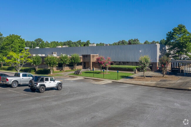
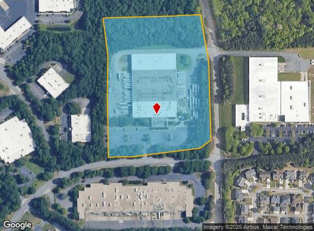
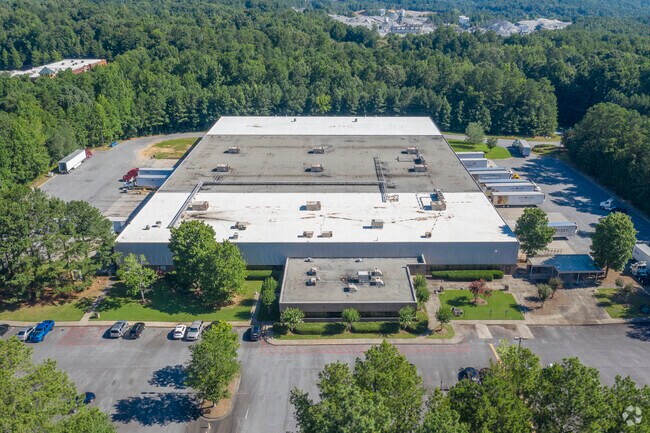
3910 Lakefield Dr, Suwanee, GA 30024

NEARBY LISTINGS FOR SALE OR LEASE
Property Detail
3910 Lakefield Dr
Atlanta-Sandy Springs-Roswell, GA
Johns Creek Comm Ind
140-017
1-1 422
Industrialgeneral
Forsyth
X
Georgia
13117C0234F
422
2024
13.27 AC
2025
N Fulton/Forsyth Cnty
130608
Atlanta
104,653 SF
DEMOGRAPHICS near 3910 Lakefield Dr
1 Mile
3 Mile
5 Mile
2024 Total Population
5,853
61,724
184,152
2029 Population
6,442
66,561
196,790
Pop Growth 2024-2029
+ 10.06%
+ 7.84%
+ 6.86%
Average Age
39
39
39
2024 Total Households
1,813
19,641
61,190
HH Growth 2024-2029
+ 9.93%
+ 7.83%
+ 6.79%
Median Household Inc
$151,873
$156,390
$135,487
Avg Household Size
3.20
3.10
3.00
2024 Avg HH Vehicles
2.00
2.00
2.00
Median Home Value
$600,342
$538,244
$470,401
Median Year Built
2006
1997
1997
Nearby Places
Map Layers
Map Styles
 Street
 Aerial
- Restaurants
- Banks
- Shops
- Fitness
- Groceries
Nearby Properties
Address
Land Use
TOTAL SIZE
Lot Size
Zoning
Address
Land Use
TOTAL SIZE
Lot Size
Zoning
321,541 SF
63.16 AC
OI
Address
Land Use
TOTAL SIZE
Lot Size
Zoning
489,097 SF
34 AC
R3
Address
Land Use
TOTAL SIZE
Lot Size
Zoning
559,910 SF
74.65 AC
Address
Land Use
TOTAL SIZE
Lot Size
Zoning
299,952 SF
23.49 AC
MIAC
Address
Land Use
TOTAL SIZE
Lot Size
Zoning
321,116 SF
17.06 AC
CBD
Address
Land Use
TOTAL SIZE
Lot Size
Zoning
47,721 SF
12.99 AC
CBD
Address
Land Use
TOTAL SIZE
Lot Size
Zoning
244,177 SF
8.96 AC
MIXU
Address
Land Use
TOTAL SIZE
Lot Size
Zoning
214,626 SF
6.29 AC
Address
Land Use
TOTAL SIZE
Lot Size
Zoning
1,650 SF
74.37 AC
AG1
Address
Land Use
TOTAL SIZE
Lot Size
Zoning
289,676 SF
4.03 AC
C1
Address
Land Use
TOTAL SIZE
Lot Size
Zoning
291,232 SF
71.66 AC
RES3
Address
Land Use
TOTAL SIZE
Lot Size
Zoning
343,180 SF
17.29 AC
OI
Address
Land Use
TOTAL SIZE
Lot Size
Zoning
163,592 SF
17.60 AC
OI
Address
Land Use
TOTAL SIZE
Lot Size
Zoning
1,845 SF
56.22 AC
AG1
Address
Land Use
TOTAL SIZE
Lot Size
Zoning
1,682 SF
303.40 AC
A1
Address
Land Use
TOTAL SIZE
Lot Size
Zoning
107,255 SF
6.12 AC
OI
Address
Land Use
TOTAL SIZE
Lot Size
Zoning
133,800 SF
5.20 AC
C1
Address
Land Use
TOTAL SIZE
Lot Size
Zoning
21.36 AC
MIXU
Address
Land Use
TOTAL SIZE
Lot Size
Zoning
14,880 SF
16.51 AC
CBD
Address
Land Use
TOTAL SIZE
Lot Size
Zoning
102,784 SF
9.16 AC
MIAC
Address
Land Use
TOTAL SIZE
Lot Size
Zoning
45,603 SF
8.36 AC
CBD
Address
Land Use
TOTAL SIZE
Lot Size
Zoning
117,036 SF
13.62 AC
CBD
Address
Land Use
TOTAL SIZE
Lot Size
Zoning
73,022 SF
6.57 AC
CBD
Address
Land Use
TOTAL SIZE
Lot Size
Zoning
1,436 SF
22.93 AC
AG1
Address
Land Use
TOTAL SIZE
Lot Size
Zoning
88,288 SF
7.76 AC
C1
Address
Land Use
TOTAL SIZE
Lot Size
Zoning
126,920 SF
12.25 AC
M1
Address
Land Use
TOTAL SIZE
Lot Size
Zoning
131.01 AC
AG1
Address
Land Use
TOTAL SIZE
Lot Size
Zoning
88,218 SF
13.36 AC
C1
Address
Land Use
TOTAL SIZE
Lot Size
Zoning
99,972 SF
5.61 AC
CBD
Address
Land Use
TOTAL SIZE
Lot Size
Zoning
98,633 SF
13.20 AC
MIAC
The World's #1 Commercial Real Estate Marketplace
Connect with us
© 2026 CoStar Group
The information above has been obtained from sources believed reliable. While we do not doubt its accuracy we have not verified it and make no guarantee, warranty or representation about it. It is your responsibility to independently confirm its accuracy and completeness. Any projections, opinions, assumptions, or estimates used are for example only and do not represent the current or future performance of the property. The value of this transaction to you depends on tax and other factors which should be evaluated by your tax, financial, and legal advisors. You and your advisors should conduct a careful, independent investigation of the property to determine to your satisfaction the suitability of the property for your needs.