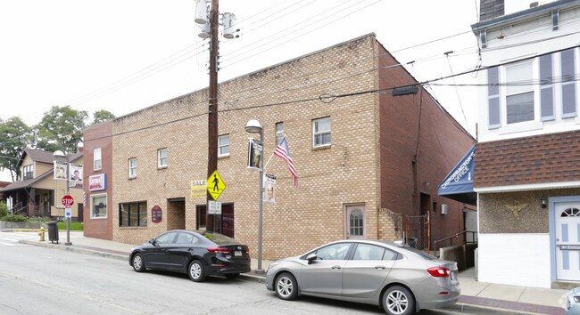
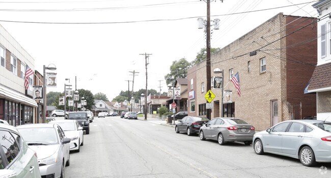
Property Record
3910 Main St, Homestead, PA 15120

Property Detail
3910 Main St
Pittsburgh, PA
HOMESTEAD PK PLAN PTS 3320-3321-3322 LOT 62.95X100 MAIN ST BRK & TILE BLDG #3910
0133-C-00053-0000-00
Allegheny
Commercialofficeresidentialmixeduse
Pennsylvania
B and X Area of moderate flood hazard, usually the area between the limits of the 100-year and 500-year floods.
53
2026
0.14 AC
2026
South Pittsburgh/Rte 51
484500
Pittsburgh
NEARBY LISTINGS FOR SALE OR LEASE
DEMOGRAPHICS near 3910 Main St
1 mile
3 mile
5 mile
2025 Total Population
11,560
68,928
270,387
2030 Population
11,371
68,777
268,969
Pop Growth 2025-2030
(1.63%)
(0.22%)
(0.52%)
Average Age
45
43
41
2025 Total Households
5,401
31,716
121,450
HH Growth 2025-2030
(1.65%)
(0.23%)
(0.61%)
Median Household Inc
$63,987
$59,587
$59,207
Avg Household Size
2.10
2.10
2.10
2025 Avg HH Vehicles
2.00
1.00
1.00
Median Home Value
$145,683
$142,824
$168,325
Median Year Built
1952
1952
1950
Nearby Places
Map Layers
Map Styles
 Street
 Aerial
Layers
 Traffic
 Biking
Places
Listings with unknown addresses are not visible on the map
- Restaurants
- Banks
- Shops
- Fitness
- Groceries
PUBLIC TRANSPORTATION
COMMUTER RAIL
Drive
Walk
Distance
19 min
8.6 mi
AIRPORT
Pittsburgh International
Drive
Walk
Distance
Pittsburgh International
44 min
25.0 mi
Arnold Palmer Regional
Drive
Walk
Distance
Arnold Palmer Regional
62 min
33.7 mi
SALE & LEASE HISTORY
LISTING DATE
SALE/LEASE

Jan 16, 2019
For Sale
Nearby Properties
Address
Land Use
TOTAL SIZE
Lot Size
Zoning
Address
Land Use
TOTAL SIZE
Lot Size
Zoning
Address
Land Use
TOTAL SIZE
Lot Size
Zoning
Address
Land Use
TOTAL SIZE
Lot Size
Zoning
18.66 AC
Address
Land Use
TOTAL SIZE
Lot Size
Zoning
Address
Land Use
TOTAL SIZE
Lot Size
Zoning
15.90 AC
Address
Land Use
TOTAL SIZE
Lot Size
Zoning
9.69 AC
Address
Land Use
TOTAL SIZE
Lot Size
Zoning
23.87 AC
Address
Land Use
TOTAL SIZE
Lot Size
Zoning
1.39 AC
Address
Land Use
TOTAL SIZE
Lot Size
Zoning
162.82 AC
Address
Land Use
TOTAL SIZE
Lot Size
Zoning
2.92 AC
Address
Land Use
TOTAL SIZE
Lot Size
Zoning
10.86 AC
Address
Land Use
TOTAL SIZE
Lot Size
Zoning
19.85 AC
Address
Land Use
TOTAL SIZE
Lot Size
Zoning
121.64 AC
Address
Land Use
TOTAL SIZE
Lot Size
Zoning
Address
Land Use
TOTAL SIZE
Lot Size
Zoning
12.51 AC
Address
Land Use
TOTAL SIZE
Lot Size
Zoning
Address
Land Use
TOTAL SIZE
Lot Size
Zoning
17.52 AC
Address
Land Use
TOTAL SIZE
Lot Size
Zoning
19.54 AC
Address
Land Use
TOTAL SIZE
Lot Size
Zoning
48.07 AC
Address
Land Use
TOTAL SIZE
Lot Size
Zoning
Address
Land Use
TOTAL SIZE
Lot Size
Zoning
Address
Land Use
TOTAL SIZE
Lot Size
Zoning
Address
Land Use
TOTAL SIZE
Lot Size
Zoning
18.09 AC
Address
Land Use
TOTAL SIZE
Lot Size
Zoning
38.94 AC
Address
Land Use
TOTAL SIZE
Lot Size
Zoning
1.51 AC
Address
Land Use
TOTAL SIZE
Lot Size
Zoning
0.92 AC
Address
Land Use
TOTAL SIZE
Lot Size
Zoning
1.65 AC
Address
Land Use
TOTAL SIZE
Lot Size
Zoning
Address
Land Use
TOTAL SIZE
Lot Size
Zoning
Address
Land Use
TOTAL SIZE
Lot Size
Zoning
The World's #1 Commercial Real Estate Marketplace
Connect with us
© 2026 CoStar Group
The information above has been obtained from sources believed reliable. While we do not doubt its accuracy we have not verified it and make no guarantee, warranty or representation about it. It is your responsibility to independently confirm its accuracy and completeness. Any projections, opinions, assumptions, or estimates used are for example only and do not represent the current or future performance of the property. The value of this transaction to you depends on tax and other factors which should be evaluated by your tax, financial, and legal advisors. You and your advisors should conduct a careful, independent investigation of the property to determine to your satisfaction the suitability of the property for your needs.