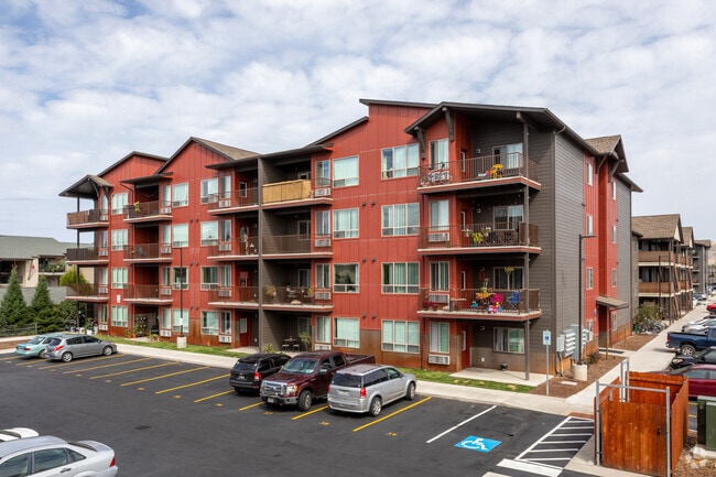
Property Record
3910 Mullan Rd, Missoula, MT 59808

NEARBY LISTINGS FOR SALE OR LEASE
Property Detail
3910 Mullan Rd
Missoula, MT
Halling Farms
04-2200-18-2-02-10-0000
HALLING FARMS, S18, T13 N, R19 W, LOT 2, ACRES 8.634, LESS CITY ROW (1.346AC)
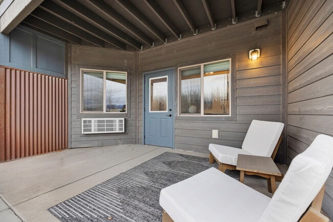
Multifamilydwelling
Missoula
X
Montana
30063C1195E
2
2024
5.01 AC
2025
Missoula
000205
Other Market Areas
175,964 SF
DEMOGRAPHICS near 3910 Mullan Rd
1 Mile
3 Mile
5 Mile
2024 Total Population
6,854
50,290
90,306
2029 Population
7,571
54,612
97,795
Pop Growth 2024-2029
+ 10.46%
+ 8.59%
+ 8.29%
Average Age
40
38
39
2024 Total Households
3,519
23,954
40,055
HH Growth 2024-2029
+ 10.63%
+ 8.75%
+ 8.48%
Median Household Inc
$48,908
$55,110
$63,685
Avg Household Size
1.80
2.00
2.10
2024 Avg HH Vehicles
1.00
2.00
2.00
Median Home Value
$337,847
$336,013
$376,004
Median Year Built
2010
1992
1984
Nearby Places
Map Layers
Map Styles
 Street
 Aerial
- Restaurants
- Banks
- Shops
- Fitness
- Groceries
PUBLIC TRANSPORTATION
AIRPORT
Missoula Montana
DRIVE
WALK
Distance
Missoula Montana
10 min
4.5 mi
Freight Ports
Port of Everett
DRIVE
WALK
Distance
Port of Everett
549 min
497.5 mi
SALE & LEASE HISTORY
LISTING DATE
SALE/LEASE

Apr 13, 2022
For Sale
Nearby Properties
Address
Land Use
TOTAL SIZE
Lot Size
Zoning
Address
Land Use
TOTAL SIZE
Lot Size
Zoning
227,454 SF
2.89 AC
2
Address
Land Use
TOTAL SIZE
Lot Size
Zoning
243,789 SF
11.95 AC
Address
Land Use
TOTAL SIZE
Lot Size
Zoning
321,769 SF
6.14 AC
1
Address
Land Use
TOTAL SIZE
Lot Size
Zoning
352,710 SF
Address
Land Use
TOTAL SIZE
Lot Size
Zoning
130,966 SF
1.06 AC
6
Address
Land Use
TOTAL SIZE
Lot Size
Zoning
252,171 SF
8.63 AC
Address
Land Use
TOTAL SIZE
Lot Size
Zoning
157,658 SF
2.04 AC
Address
Land Use
TOTAL SIZE
Lot Size
Zoning
187,680 SF
10.06 AC
Address
Land Use
TOTAL SIZE
Lot Size
Zoning
61,762 SF
8.48 AC
Address
Land Use
TOTAL SIZE
Lot Size
Zoning
179,712 SF
7.60 AC
Address
Land Use
TOTAL SIZE
Lot Size
Zoning
50,795 SF
18.10 AC
Address
Land Use
TOTAL SIZE
Lot Size
Zoning
28,161 SF
0.31 AC
6
Address
Land Use
TOTAL SIZE
Lot Size
Zoning
138,544 SF
5.28 AC
Address
Land Use
TOTAL SIZE
Lot Size
Zoning
61,800 SF
6.11 AC
Address
Land Use
TOTAL SIZE
Lot Size
Zoning
35,884 SF
7.40 AC
6
Address
Land Use
TOTAL SIZE
Lot Size
Zoning
125,976 SF
10.64 AC
1
Address
Land Use
TOTAL SIZE
Lot Size
Zoning
73,710 SF
12.42 AC
Address
Land Use
TOTAL SIZE
Lot Size
Zoning
128,120 SF
1.15 AC
5
Address
Land Use
TOTAL SIZE
Lot Size
Zoning
104,592 SF
3.36 AC
6
Address
Land Use
TOTAL SIZE
Lot Size
Zoning
73,710 SF
12.42 AC
Address
Land Use
TOTAL SIZE
Lot Size
Zoning
55,528 SF
36.48 AC
Address
Land Use
TOTAL SIZE
Lot Size
Zoning
205,960 SF
18.52 AC
Address
Land Use
TOTAL SIZE
Lot Size
Zoning
105,004 SF
3.45 AC
Address
Land Use
TOTAL SIZE
Lot Size
Zoning
73,143 SF
6.54 AC
7
Address
Land Use
TOTAL SIZE
Lot Size
Zoning
133,210 SF
11.25 AC
Address
Land Use
TOTAL SIZE
Lot Size
Zoning
73,411 SF
0.68 AC
6
Address
Land Use
TOTAL SIZE
Lot Size
Zoning
55,280 SF
3.12 AC
Address
Land Use
TOTAL SIZE
Lot Size
Zoning
31,523 SF
5 AC
Address
Land Use
TOTAL SIZE
Lot Size
Zoning
66,900 SF
0.25 AC
6
The World's #1 Commercial Real Estate Marketplace
Connect with us
© 2026 CoStar Group
The information above has been obtained from sources believed reliable. While we do not doubt its accuracy we have not verified it and make no guarantee, warranty or representation about it. It is your responsibility to independently confirm its accuracy and completeness. Any projections, opinions, assumptions, or estimates used are for example only and do not represent the current or future performance of the property. The value of this transaction to you depends on tax and other factors which should be evaluated by your tax, financial, and legal advisors. You and your advisors should conduct a careful, independent investigation of the property to determine to your satisfaction the suitability of the property for your needs.