Property Record
3910 S Teller St, Denver, CO 80235
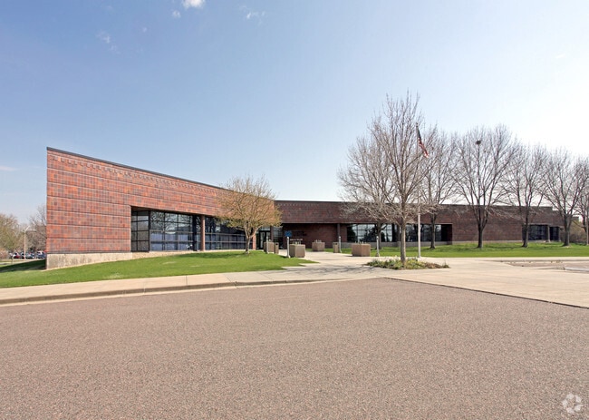


Property Detail
3910 S Teller St
Denver-Aurora-Centennial, CO
SECTION 02 TOWNSHIP 05 RANGE 69 SUBDIVISIONCD 759311 SUBDIVISIONNAME TRAVELERS EXPRESS FLG NO 1 LL ADJ NO 1 BLOCK 001 LOT 0001 SIZE: 266332 VALUE: 6.114
59-024-01-013
JEFFERSON
Commercialnec
Colorado
B and X Area of moderate flood hazard, usually the area between the limits of the 100-year and 500-year floods.
1
2025
6.11 AC
2025
Southwest Denver
011904
Denver
34,304 SF
NEARBY LISTINGS FOR SALE OR LEASE
DEMOGRAPHICS near 3910 S Teller St
1 mile
3 mile
5 mile
2025 Total Population
12,768
108,312
315,884
2030 Population
12,881
108,877
316,600
Pop Growth 2025-2030
+ 0.89%
+ 0.52%
+ 0.23%
Average Age
40
41
41
2025 Total Households
6,073
44,121
125,601
HH Growth 2025-2030
+ 0.86%
+ 0.55%
+ 0.28%
Median Household Inc
$70,488
$93,016
$93,972
Avg Household Size
2.10
2.40
2.40
2025 Avg HH Vehicles
2.00
2.00
2.00
Median Home Value
$443,774
$611,055
$616,429
Median Year Built
1987
1980
1976
Nearby Places
Map Layers
Map Styles
 Street
 Aerial
Layers
 Traffic
 Biking
Places
Listings with unknown addresses are not visible on the map
- Restaurants
- Banks
- Shops
- Fitness
- Groceries
PUBLIC TRANSPORTATION
AIRPORT
Denver International
Drive
Walk
Distance
Denver International
50 min
36.4 mi
Freight Ports
Tulsa Port Of Catoosa
Drive
Walk
Distance
Tulsa Port Of Catoosa
746 min
719.1 mi
Nearby Properties
Address
Land Use
TOTAL SIZE
Lot Size
Zoning
Address
Land Use
TOTAL SIZE
Lot Size
Zoning
117,535 SF
4.76 AC
Address
Land Use
TOTAL SIZE
Lot Size
Zoning
172,644 SF
8.77 AC
Address
Land Use
TOTAL SIZE
Lot Size
Zoning
665,722 SF
615.85 AC
OS-B
Address
Land Use
TOTAL SIZE
Lot Size
Zoning
330,776 SF
48.11 AC
CMP-H2
Address
Land Use
TOTAL SIZE
Lot Size
Zoning
248,291 SF
128.77 AC
CMP-H2
Address
Land Use
TOTAL SIZE
Lot Size
Zoning
381,135 SF
35.02 AC
Address
Land Use
TOTAL SIZE
Lot Size
Zoning
255,381 SF
16.52 AC
Address
Land Use
TOTAL SIZE
Lot Size
Zoning
304,560 SF
23.94 AC
S-SU-F
Address
Land Use
TOTAL SIZE
Lot Size
Zoning
298,752 SF
73.96 AC
Address
Land Use
TOTAL SIZE
Lot Size
Zoning
208,529 SF
34.81 AC
R-5
Address
Land Use
TOTAL SIZE
Lot Size
Zoning
600,847 SF
35.87 AC
PD
Address
Land Use
TOTAL SIZE
Lot Size
Zoning
600,847 SF
32.41 AC
PD
Address
Land Use
TOTAL SIZE
Lot Size
Zoning
221,025 SF
8.45 AC
PUD
Address
Land Use
TOTAL SIZE
Lot Size
Zoning
178,421 SF
12.31 AC
PD
Address
Land Use
TOTAL SIZE
Lot Size
Zoning
501,310 SF
12.56 AC
Address
Land Use
TOTAL SIZE
Lot Size
Zoning
272,775 SF
27.94 AC
Address
Land Use
TOTAL SIZE
Lot Size
Zoning
107,159 SF
26.40 AC
Address
Land Use
TOTAL SIZE
Lot Size
Zoning
304,475 SF
22.32 AC
Address
Land Use
TOTAL SIZE
Lot Size
Zoning
68,082 SF
3.09 AC
S-MU
Address
Land Use
TOTAL SIZE
Lot Size
Zoning
35,901 SF
2.81 AC
Address
Land Use
TOTAL SIZE
Lot Size
Zoning
446,582 SF
19.24 AC
Address
Land Use
TOTAL SIZE
Lot Size
Zoning
10,260 SF
49.33 AC
CMP-H2
Address
Land Use
TOTAL SIZE
Lot Size
Zoning
205,949 SF
16.46 AC
S-SU-F
Address
Land Use
TOTAL SIZE
Lot Size
Zoning
133,594 SF
25.03 AC
Address
Land Use
TOTAL SIZE
Lot Size
Zoning
94,367 SF
10.02 AC
R-2
Address
Land Use
TOTAL SIZE
Lot Size
Zoning
63,347 SF
20.70 AC
Address
Land Use
TOTAL SIZE
Lot Size
Zoning
115,056 SF
6.17 AC
CMP-EI2
Address
Land Use
TOTAL SIZE
Lot Size
Zoning
123,843 SF
6.03 AC
Address
Land Use
TOTAL SIZE
Lot Size
Zoning
189,672 SF
16.74 AC
PD
Address
Land Use
TOTAL SIZE
Lot Size
Zoning
329,538 SF
14.64 AC
B-4
The World's #1 Commercial Real Estate Marketplace
Connect with us
© 2026 CoStar Group
The information above has been obtained from sources believed reliable. While we do not doubt its accuracy we have not verified it and make no guarantee, warranty or representation about it. It is your responsibility to independently confirm its accuracy and completeness. Any projections, opinions, assumptions, or estimates used are for example only and do not represent the current or future performance of the property. The value of this transaction to you depends on tax and other factors which should be evaluated by your tax, financial, and legal advisors. You and your advisors should conduct a careful, independent investigation of the property to determine to your satisfaction the suitability of the property for your needs.