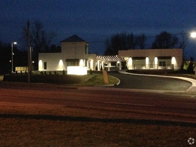
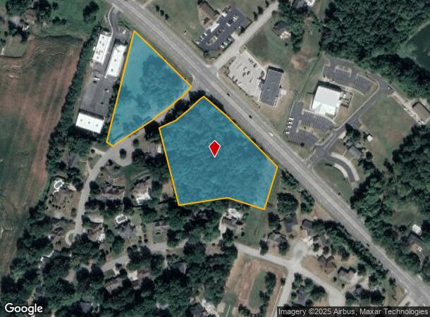
Property Record
3910 State Route 54, Owensboro, KY 42303
NEARBY LISTINGS FOR SALE OR LEASE
Property Detail
3910 State Route 54
Commercialnec
75-23910 HWY 545.478 ACRES
X
Daviess
21059C0281E
Kentucky
2025
5.47 AC
2025
Other Market Areas
000401
Owensboro, KY
1,247 SF
075-00-00-002-00-000
DEMOGRAPHICS near 3910 State Route 54
1 Mile
3 Mile
5 Mile
2024 Total Population
5,701
28,992
63,935
2029 Population
5,684
29,174
64,379
Pop Growth 2024-2029
(0.30%)
+ 0.63%
+ 0.69%
Average Age
42
40
40
2024 Total Households
2,220
11,452
25,762
HH Growth 2024-2029
(0.32%)
+ 0.63%
+ 0.71%
Median Household Inc
$95,688
$65,068
$58,689
Avg Household Size
2.60
2.40
2.40
2024 Avg HH Vehicles
2.00
2.00
2.00
Median Home Value
$247,550
$195,577
$173,570
Median Year Built
1997
1983
1973
Nearby Places
Map Layers
Map Styles
 Street
 Aerial
- Restaurants
- Banks
- Shops
- Fitness
- Groceries
SALE & LEASE HISTORY
LISTING DATE
SALE/LEASE

Feb 27, 2017
For Lease
Nearby Properties
Address
Land Use
TOTAL SIZE
Lot Size
Zoning
Address
Land Use
TOTAL SIZE
Lot Size
Zoning
975,956 SF
143.98 AC
Address
Land Use
TOTAL SIZE
Lot Size
Zoning
4,361 SF
17.09 AC
Address
Land Use
TOTAL SIZE
Lot Size
Zoning
270,464 SF
100.67 AC
Address
Land Use
TOTAL SIZE
Lot Size
Zoning
28,032 SF
18.13 AC
Address
Land Use
TOTAL SIZE
Lot Size
Zoning
227,450 SF
30.70 AC
Address
Land Use
TOTAL SIZE
Lot Size
Zoning
187,364 SF
18.64 AC
Address
Land Use
TOTAL SIZE
Lot Size
Zoning
4.73 AC
Address
Land Use
TOTAL SIZE
Lot Size
Zoning
214,489 SF
22.72 AC
Address
Land Use
TOTAL SIZE
Lot Size
Zoning
7.63 AC
Address
Land Use
TOTAL SIZE
Lot Size
Zoning
Address
Land Use
TOTAL SIZE
Lot Size
Zoning
9,725 SF
22.36 AC
Address
Land Use
TOTAL SIZE
Lot Size
Zoning
655,471 SF
31.03 AC
Address
Land Use
TOTAL SIZE
Lot Size
Zoning
67,431 SF
3.53 AC
Address
Land Use
TOTAL SIZE
Lot Size
Zoning
Address
Land Use
TOTAL SIZE
Lot Size
Zoning
207,292 SF
17.74 AC
Address
Land Use
TOTAL SIZE
Lot Size
Zoning
22,478 SF
19.59 AC
Address
Land Use
TOTAL SIZE
Lot Size
Zoning
69,912 SF
20.30 AC
Address
Land Use
TOTAL SIZE
Lot Size
Zoning
2.92 AC
Address
Land Use
TOTAL SIZE
Lot Size
Zoning
17,920 SF
10.60 AC
Address
Land Use
TOTAL SIZE
Lot Size
Zoning
9.53 AC
Address
Land Use
TOTAL SIZE
Lot Size
Zoning
39,729 SF
3.44 AC
Address
Land Use
TOTAL SIZE
Lot Size
Zoning
101,268 SF
49.13 AC
Address
Land Use
TOTAL SIZE
Lot Size
Zoning
91,284 SF
9.99 AC
Address
Land Use
TOTAL SIZE
Lot Size
Zoning
9,000 SF
25 AC
Address
Land Use
TOTAL SIZE
Lot Size
Zoning
Address
Land Use
TOTAL SIZE
Lot Size
Zoning
58,573 SF
5.93 AC
Address
Land Use
TOTAL SIZE
Lot Size
Zoning
60,902 SF
24.82 AC
Address
Land Use
TOTAL SIZE
Lot Size
Zoning
16,373 SF
20.90 AC
Address
Land Use
TOTAL SIZE
Lot Size
Zoning
69,732 SF
14.74 AC
Address
Land Use
TOTAL SIZE
Lot Size
Zoning
46,646 SF
3.53 AC
The World's #1 Commercial Real Estate Marketplace
Connect with us
© 2025 CoStar Group
The information above has been obtained from sources believed reliable. While we do not doubt its accuracy we have not verified it and make no guarantee, warranty or representation about it. It is your responsibility to independently confirm its accuracy and completeness. Any projections, opinions, assumptions, or estimates used are for example only and do not represent the current or future performance of the property. The value of this transaction to you depends on tax and other factors which should be evaluated by your tax, financial, and legal advisors. You and your advisors should conduct a careful, independent investigation of the property to determine to your satisfaction the suitability of the property for your needs.