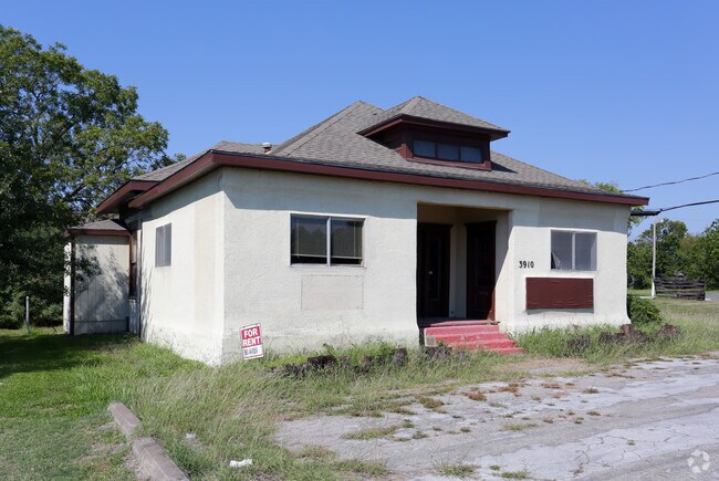
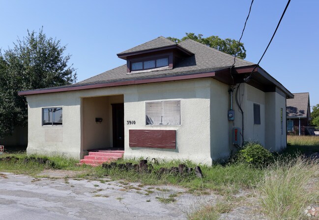
Property Record
3910 Wesley St, Greenville, TX 75401

Property Detail
3910 Wesley St
71654
S4385 ORIG TOWN OF GREENVILLE BLK 194 LOT 2B ACRES .1899
Commercialnec
Hunt
GR
Texas
B and X Area of moderate flood hazard, usually the area between the limits of the 100-year and 500-year floods.
2b
2024
0.19 AC
2025
Hunt County
960900
Dallas/Ft Worth
1,518 SF
Dallas-Fort Worth-Arlington, TX
NEARBY LISTINGS FOR SALE OR LEASE
DEMOGRAPHICS near 3910 Wesley St
1 mile
3 mile
5 mile
2025 Total Population
10,056
31,015
37,079
2030 Population
11,677
36,193
43,265
Pop Growth 2025-2030
+ 16.12%
+ 16.70%
+ 16.68%
Average Age
36
37
38
2025 Total Households
3,595
11,717
13,946
HH Growth 2025-2030
+ 16.44%
+ 17.00%
+ 16.99%
Median Household Inc
$60,478
$64,100
$67,300
Avg Household Size
2.70
2.50
2.60
2025 Avg HH Vehicles
2.00
2.00
2.00
Median Home Value
$177,292
$222,114
$235,097
Median Year Built
1974
1980
1983
Nearby Places
Map Layers
Map Styles
 Street
 Aerial
Layers
 Traffic
 Biking
Places
Listings with unknown addresses are not visible on the map
- Restaurants
- Banks
- Shops
- Fitness
- Groceries
SALE & LEASE HISTORY
LISTING DATE
SALE/LEASE

Oct 04, 2016
For Lease
Nearby Properties
Address
Land Use
TOTAL SIZE
Lot Size
Zoning
Address
Land Use
TOTAL SIZE
Lot Size
Zoning
243,495 SF
18.01 AC
Address
Land Use
TOTAL SIZE
Lot Size
Zoning
Address
Land Use
TOTAL SIZE
Lot Size
Zoning
333,000 SF
1.14 AC
Address
Land Use
TOTAL SIZE
Lot Size
Zoning
311,060 SF
92.32 AC
Address
Land Use
TOTAL SIZE
Lot Size
Zoning
144,437 SF
4.96 AC
Address
Land Use
TOTAL SIZE
Lot Size
Zoning
188,688 SF
13.47 AC
Address
Land Use
TOTAL SIZE
Lot Size
Zoning
144,327 SF
24.79 AC
Address
Land Use
TOTAL SIZE
Lot Size
Zoning
1,040,000 SF
93.75 AC
Address
Land Use
TOTAL SIZE
Lot Size
Zoning
346,383 SF
27.64 AC
C
Address
Land Use
TOTAL SIZE
Lot Size
Zoning
246,730 SF
21.80 AC
C
Address
Land Use
TOTAL SIZE
Lot Size
Zoning
278,577 SF
19.62 AC
Address
Land Use
TOTAL SIZE
Lot Size
Zoning
43,516 SF
108.86 AC
Address
Land Use
TOTAL SIZE
Lot Size
Zoning
81,021 SF
1.07 AC
Address
Land Use
TOTAL SIZE
Lot Size
Zoning
91,672 SF
44.64 AC
Address
Land Use
TOTAL SIZE
Lot Size
Zoning
136,151 SF
6.50 AC
Address
Land Use
TOTAL SIZE
Lot Size
Zoning
201,245 SF
28.42 AC
Address
Land Use
TOTAL SIZE
Lot Size
Zoning
155,301 SF
8.01 AC
C
Address
Land Use
TOTAL SIZE
Lot Size
Zoning
316,991 SF
49.61 AC
I
Address
Land Use
TOTAL SIZE
Lot Size
Zoning
284,091 SF
29.47 AC
I
Address
Land Use
TOTAL SIZE
Lot Size
Zoning
79,118 SF
9.70 AC
Address
Land Use
TOTAL SIZE
Lot Size
Zoning
119,765 SF
5.30 AC
2F
Address
Land Use
TOTAL SIZE
Lot Size
Zoning
135,300 SF
17.50 AC
Address
Land Use
TOTAL SIZE
Lot Size
Zoning
52,693 SF
12.86 AC
Address
Land Use
TOTAL SIZE
Lot Size
Zoning
91,384 SF
14.61 AC
MF
Address
Land Use
TOTAL SIZE
Lot Size
Zoning
115,908 SF
12.80 AC
Address
Land Use
TOTAL SIZE
Lot Size
Zoning
129,700 SF
12.69 AC
Address
Land Use
TOTAL SIZE
Lot Size
Zoning
46,858 SF
3.96 AC
Address
Land Use
TOTAL SIZE
Lot Size
Zoning
138,858 SF
49.30 AC
Address
Land Use
TOTAL SIZE
Lot Size
Zoning
92,176 SF
5.26 AC
Address
Land Use
TOTAL SIZE
Lot Size
Zoning
99,850 SF
10.62 AC
The World's #1 Commercial Real Estate Marketplace
Connect with us
© 2026 CoStar Group
The information above has been obtained from sources believed reliable. While we do not doubt its accuracy we have not verified it and make no guarantee, warranty or representation about it. It is your responsibility to independently confirm its accuracy and completeness. Any projections, opinions, assumptions, or estimates used are for example only and do not represent the current or future performance of the property. The value of this transaction to you depends on tax and other factors which should be evaluated by your tax, financial, and legal advisors. You and your advisors should conduct a careful, independent investigation of the property to determine to your satisfaction the suitability of the property for your needs.