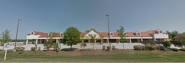
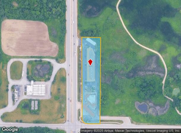
Property Record
39105 N Us Highway 41, Wadsworth, IL 60083
Current Lease Availabilities
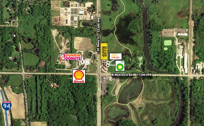
NEARBY LISTINGS FOR SALE OR LEASE
-
-
View all Wadsworth listings for lease on LoopNet.com
Property Detail
39105 N Us Highway 41
03-27-300-024
Pt Se1/4
Commercialbuilding
PT SE1/4 SW1/4, BEG AT PT ON SLN 307.5 EOF SW COR, N290, C ONT N 603.06, W TO WLN SW 1/4, S 603.06, CONT S 290 TO S W COR, E 307.5 TO POB (EX PT TKN FOR RD) SECTION 27 TOWNSHI
X
Lake
17097C0066L
Illinois
2023
3.48 AC
2024
Far North
866000
Chicago
55,868 SF
Chicago-Naperville-Elgin, IL-IN-WI
DEMOGRAPHICS near 39105 N Us Highway 41
1 Mile
3 Mile
5 Mile
2024 Total Population
480
13,468
83,290
2029 Population
461
13,144
82,070
Pop Growth 2024-2029
(3.96%)
(2.41%)
(1.46%)
Average Age
46
41
39
2024 Total Households
178
4,929
29,627
HH Growth 2024-2029
(4.49%)
(2.52%)
(1.60%)
Median Household Inc
$105,092
$98,141
$89,121
Avg Household Size
2.60
2.70
2.80
2024 Avg HH Vehicles
2.00
2.00
2.00
Median Home Value
$379,786
$270,817
$233,262
Median Year Built
1981
1994
1986
Nearby Places
- Restaurants
- Banks
- Shops
- Fitness
- Groceries
PUBLIC TRANSPORTATION
COMMUTER RAIL
Zion Station (Union Pacific North Line - Northeast Illinois Regional Commuter Railroad (Metra))
DRIVE
WALK
Distance
Zion Station (Union Pacific North Line - Northeast Illinois Regional Commuter Railroad (Metra))
16 min
7.5 mi
Freight Ports
Port Milwaukee
DRIVE
WALK
Distance
Port Milwaukee
48 min
41.6 mi
Nearby Properties
Address
Land Use
TOTAL SIZE
Lot Size
Zoning
Address
Land Use
TOTAL SIZE
Lot Size
Zoning
914,522 SF
7.81 AC
Address
Land Use
TOTAL SIZE
Lot Size
Zoning
218,500 SF
9.86 AC
Address
Land Use
TOTAL SIZE
Lot Size
Zoning
79,458 SF
6.79 AC
Address
Land Use
TOTAL SIZE
Lot Size
Zoning
122,314 SF
5.95 AC
Address
Land Use
TOTAL SIZE
Lot Size
Zoning
1,148,346 SF
7.90 AC
Address
Land Use
TOTAL SIZE
Lot Size
Zoning
218,500 SF
10.46 AC
Address
Land Use
TOTAL SIZE
Lot Size
Zoning
84,976 SF
2.41 AC
Address
Land Use
TOTAL SIZE
Lot Size
Zoning
83,996 SF
4.80 AC
Address
Land Use
TOTAL SIZE
Lot Size
Zoning
64,860 SF
7.59 AC
Address
Land Use
TOTAL SIZE
Lot Size
Zoning
112,836 SF
5.85 AC
Address
Land Use
TOTAL SIZE
Lot Size
Zoning
66,501 SF
3.19 AC
Address
Land Use
TOTAL SIZE
Lot Size
Zoning
7,450 SF
21.35 AC
Address
Land Use
TOTAL SIZE
Lot Size
Zoning
66,522 SF
5.15 AC
Address
Land Use
TOTAL SIZE
Lot Size
Zoning
34,060 SF
11.41 AC
Address
Land Use
TOTAL SIZE
Lot Size
Zoning
41,760 SF
1.78 AC
Address
Land Use
TOTAL SIZE
Lot Size
Zoning
41,760 SF
1.37 AC
Address
Land Use
TOTAL SIZE
Lot Size
Zoning
67,400 SF
5.78 AC
Address
Land Use
TOTAL SIZE
Lot Size
Zoning
41,161 SF
608.77 AC
Address
Land Use
TOTAL SIZE
Lot Size
Zoning
30,615 SF
5.71 AC
Address
Land Use
TOTAL SIZE
Lot Size
Zoning
34,106 SF
0.88 AC
Address
Land Use
TOTAL SIZE
Lot Size
Zoning
31,344 SF
2.13 AC
Address
Land Use
TOTAL SIZE
Lot Size
Zoning
7,940 SF
10 AC
Address
Land Use
TOTAL SIZE
Lot Size
Zoning
32,202 SF
1.01 AC
Address
Land Use
TOTAL SIZE
Lot Size
Zoning
32,202 SF
0.95 AC
Address
Land Use
TOTAL SIZE
Lot Size
Zoning
36,913 SF
1.47 AC
Address
Land Use
TOTAL SIZE
Lot Size
Zoning
41,078 SF
12.08 AC
Address
Land Use
TOTAL SIZE
Lot Size
Zoning
29,274 SF
0.48 AC
Address
Land Use
TOTAL SIZE
Lot Size
Zoning
29,274 SF
0.43 AC
Address
Land Use
TOTAL SIZE
Lot Size
Zoning
29,752 SF
27.92 AC
The World's #1 Commercial Real Estate Marketplace
Connect with us
© 2025 CoStar Group
The information above has been obtained from sources believed reliable. While we do not doubt its accuracy we have not verified it and make no guarantee, warranty or representation about it. It is your responsibility to independently confirm its accuracy and completeness. Any projections, opinions, assumptions, or estimates used are for example only and do not represent the current or future performance of the property. The value of this transaction to you depends on tax and other factors which should be evaluated by your tax, financial, and legal advisors. You and your advisors should conduct a careful, independent investigation of the property to determine to your satisfaction the suitability of the property for your needs.