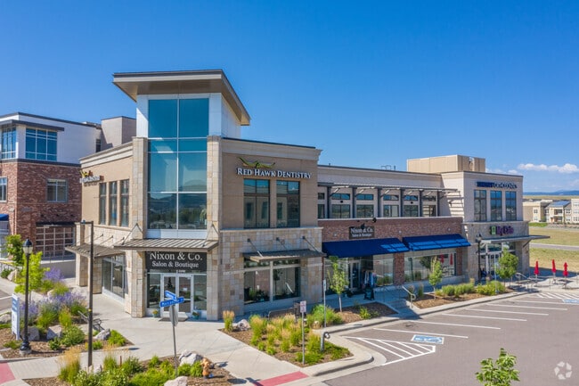
Property Record
3911 Ambrosia St, Castle Rock, CO 80109
NEARBY LISTINGS FOR SALE OR LEASE
Property Detail
3911 Ambrosia St
Denver-Aurora-Lakewood, CO
Meadows The
2351-342-10-001
LOT 1A BLOCK 3 MEADOWS 20 PHASE 1 AMD 2 0.255 AM/L
Commercialnec
Douglas
X
Colorado
08035C0169G
1a
2024
0.46 AC
2025
Parker/Castle Rock
014410
Denver
27,637 SF
DEMOGRAPHICS near 3911 Ambrosia St
1 Mile
3 Mile
5 Mile
2024 Total Population
11,801
46,979
84,086
2029 Population
13,634
53,556
96,112
Pop Growth 2024-2029
+ 15.53%
+ 14.00%
+ 14.30%
Average Age
36
38
39
2024 Total Households
4,075
16,641
29,572
HH Growth 2024-2029
+ 15.68%
+ 14.15%
+ 14.41%
Median Household Inc
$135,056
$127,465
$131,906
Avg Household Size
2.80
2.70
2.80
2024 Avg HH Vehicles
2.00
2.00
2.00
Median Home Value
$592,360
$638,461
$633,293
Median Year Built
2010
2004
2003
Nearby Places
Map Layers
Map Styles
 Street
 Aerial
- Restaurants
- Banks
- Shops
- Fitness
- Groceries
PUBLIC TRANSPORTATION
AIRPORT
Denver International
DRIVE
WALK
Distance
Denver International
49 min
45.1 mi
SALE & LEASE HISTORY
LISTING DATE
SALE/LEASE

Oct 27, 2021
For Lease
Mar 15, 2023
For Lease
Nearby Properties
Address
Land Use
TOTAL SIZE
Lot Size
Zoning
Address
Land Use
TOTAL SIZE
Lot Size
Zoning
836,412 SF
29.20 AC
Address
Land Use
TOTAL SIZE
Lot Size
Zoning
297,865 SF
39.95 AC
Address
Land Use
TOTAL SIZE
Lot Size
Zoning
467,796 SF
55.80 AC
Address
Land Use
TOTAL SIZE
Lot Size
Zoning
463,911 SF
55.80 AC
Address
Land Use
TOTAL SIZE
Lot Size
Zoning
218,106 SF
35.19 AC
Address
Land Use
TOTAL SIZE
Lot Size
Zoning
117,447 SF
9.99 AC
Address
Land Use
TOTAL SIZE
Lot Size
Zoning
128,680 SF
21.86 AC
Address
Land Use
TOTAL SIZE
Lot Size
Zoning
345,078 SF
10.16 AC
Address
Land Use
TOTAL SIZE
Lot Size
Zoning
112,044 SF
7.85 AC
PDU
Address
Land Use
TOTAL SIZE
Lot Size
Zoning
115,552 SF
14.04 AC
Address
Land Use
TOTAL SIZE
Lot Size
Zoning
464,037 SF
18.90 AC
Address
Land Use
TOTAL SIZE
Lot Size
Zoning
392,610 SF
15.21 AC
Address
Land Use
TOTAL SIZE
Lot Size
Zoning
53,560 SF
32.09 AC
Address
Land Use
TOTAL SIZE
Lot Size
Zoning
150,896 SF
1.38 AC
Address
Land Use
TOTAL SIZE
Lot Size
Zoning
62,718 SF
3.47 AC
Address
Land Use
TOTAL SIZE
Lot Size
Zoning
122,581 SF
13.81 AC
Address
Land Use
TOTAL SIZE
Lot Size
Zoning
105,496 SF
10.22 AC
Address
Land Use
TOTAL SIZE
Lot Size
Zoning
227,703 SF
48.20 AC
A1
Address
Land Use
TOTAL SIZE
Lot Size
Zoning
178,877 SF
1.34 AC
Address
Land Use
TOTAL SIZE
Lot Size
Zoning
73,146 SF
10.25 AC
Address
Land Use
TOTAL SIZE
Lot Size
Zoning
407,977 SF
15.04 AC
Address
Land Use
TOTAL SIZE
Lot Size
Zoning
59,843 SF
39.95 AC
Address
Land Use
TOTAL SIZE
Lot Size
Zoning
47,354 SF
14.93 AC
Address
Land Use
TOTAL SIZE
Lot Size
Zoning
136,674 SF
16.43 AC
Address
Land Use
TOTAL SIZE
Lot Size
Zoning
250,910 SF
12.06 AC
Address
Land Use
TOTAL SIZE
Lot Size
Zoning
256,820 SF
11.02 AC
A1
Address
Land Use
TOTAL SIZE
Lot Size
Zoning
115,466 SF
1.05 AC
Address
Land Use
TOTAL SIZE
Lot Size
Zoning
115,324 SF
7.44 AC
Address
Land Use
TOTAL SIZE
Lot Size
Zoning
253,264 SF
12.79 AC
Address
Land Use
TOTAL SIZE
Lot Size
Zoning
56,822 SF
10.01 AC
The World's #1 Commercial Real Estate Marketplace
Connect with us
© 2026 CoStar Group
The information above has been obtained from sources believed reliable. While we do not doubt its accuracy we have not verified it and make no guarantee, warranty or representation about it. It is your responsibility to independently confirm its accuracy and completeness. Any projections, opinions, assumptions, or estimates used are for example only and do not represent the current or future performance of the property. The value of this transaction to you depends on tax and other factors which should be evaluated by your tax, financial, and legal advisors. You and your advisors should conduct a careful, independent investigation of the property to determine to your satisfaction the suitability of the property for your needs.