Property Record
3911 E 19Th St, Texarkana, AR 71854

Property Detail
3911 E 19Th St
00288902
PT NE
Autorepair
MILLER
B and X Area of moderate flood hazard, usually the area between the limits of the 100-year and 500-year floods.
Arkansas
2025
2 AC
2025
Arkansas South Area
980000
Other Market Areas
5,246 SF
Texarkana, TX-AR
NEARBY LISTINGS FOR SALE OR LEASE
DEMOGRAPHICS near 3911 E 19Th St
1 mile
3 mile
5 mile
2024 Total Population
1,157
27,977
52,089
2029 Population
1,141
27,638
51,707
Pop Growth 2024-2029
(1.38%)
(1.21%)
(0.73%)
Average Age
40
39
39
2024 Total Households
511
11,010
20,904
HH Growth 2024-2029
(1.37%)
(1.30%)
(0.77%)
Median Household Inc
$53,587
$42,535
$43,704
Avg Household Size
2.20
2.30
2.30
2024 Avg HH Vehicles
2.00
2.00
2.00
Median Home Value
$202,577
$141,026
$140,000
Median Year Built
1977
1975
1976
Nearby Places
Map Layers
Map Styles
 Street
 Aerial
Transit
 Traffic
 Biking
Places
Listings with unknown addresses are not visible on the map
- Restaurants
- Banks
- Shops
- Fitness
- Groceries
PUBLIC TRANSPORTATION
COMMUTER RAIL
Texarkana Amtrak Station (Texas Eagle - Amtrak)
Drive
Walk
Distance
Texarkana Amtrak Station (Texas Eagle - Amtrak)
7 min
3.5 mi
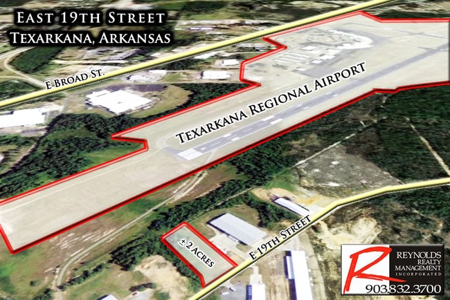
AIRPORT
Texarkana Regional-Webb Field
Drive
Walk
Distance
Texarkana Regional-Webb Field
5 min
1.3 mi
Freight Ports
Port of Shreveport
Drive
Walk
Distance
Port of Shreveport
106 min
93.4 mi
Nearby Properties
Address
Land Use
TOTAL SIZE
Lot Size
Zoning
Address
Land Use
TOTAL SIZE
Lot Size
Zoning
1,896,910 SF
46.19 AC
Address
Land Use
TOTAL SIZE
Lot Size
Zoning
Address
Land Use
TOTAL SIZE
Lot Size
Zoning
1,896,910 SF
Address
Land Use
TOTAL SIZE
Lot Size
Zoning
102,614 SF
0.89 AC
Address
Land Use
TOTAL SIZE
Lot Size
Zoning
100,000 SF
5.92 AC
Address
Land Use
TOTAL SIZE
Lot Size
Zoning
74,246 SF
1.34 AC
Address
Land Use
TOTAL SIZE
Lot Size
Zoning
128,150 SF
11.57 AC
Address
Land Use
TOTAL SIZE
Lot Size
Zoning
55,033 SF
Address
Land Use
TOTAL SIZE
Lot Size
Zoning
4.43 AC
Address
Land Use
TOTAL SIZE
Lot Size
Zoning
219,618 SF
17.61 AC
Address
Land Use
TOTAL SIZE
Lot Size
Zoning
68,006 SF
4.86 AC
Address
Land Use
TOTAL SIZE
Lot Size
Zoning
101,440 SF
4 AC
Address
Land Use
TOTAL SIZE
Lot Size
Zoning
67,944 SF
13.78 AC
Address
Land Use
TOTAL SIZE
Lot Size
Zoning
270,796 SF
33.10 AC
Address
Land Use
TOTAL SIZE
Lot Size
Zoning
185,060 SF
Address
Land Use
TOTAL SIZE
Lot Size
Zoning
15,048 SF
1.61 AC
Address
Land Use
TOTAL SIZE
Lot Size
Zoning
96,550 SF
3.38 AC
Address
Land Use
TOTAL SIZE
Lot Size
Zoning
2.55 AC
Address
Land Use
TOTAL SIZE
Lot Size
Zoning
17,152 SF
3.15 AC
Address
Land Use
TOTAL SIZE
Lot Size
Zoning
28,480 SF
0.96 AC
Address
Land Use
TOTAL SIZE
Lot Size
Zoning
179,723 SF
36.84 AC
Address
Land Use
TOTAL SIZE
Lot Size
Zoning
26,696 SF
1.29 AC
Address
Land Use
TOTAL SIZE
Lot Size
Zoning
21,296 SF
1.82 AC
Address
Land Use
TOTAL SIZE
Lot Size
Zoning
22,840 SF
1.43 AC
Address
Land Use
TOTAL SIZE
Lot Size
Zoning
47,776 SF
8 AC
Address
Land Use
TOTAL SIZE
Lot Size
Zoning
54,136 SF
7.45 AC
Address
Land Use
TOTAL SIZE
Lot Size
Zoning
36,320 SF
2.98 AC
Address
Land Use
TOTAL SIZE
Lot Size
Zoning
5,052 SF
8.73 AC
Address
Land Use
TOTAL SIZE
Lot Size
Zoning
26,721 SF
0.32 AC
Address
Land Use
TOTAL SIZE
Lot Size
Zoning
29,678 SF
1.52 AC
The World's #1 Commercial Real Estate Marketplace
Connect with us
© 2026 CoStar Group
The information above has been obtained from sources believed reliable. While we do not doubt its accuracy we have not verified it and make no guarantee, warranty or representation about it. It is your responsibility to independently confirm its accuracy and completeness. Any projections, opinions, assumptions, or estimates used are for example only and do not represent the current or future performance of the property. The value of this transaction to you depends on tax and other factors which should be evaluated by your tax, financial, and legal advisors. You and your advisors should conduct a careful, independent investigation of the property to determine to your satisfaction the suitability of the property for your needs.