Property Record
3914 Cornell Pl, Frederick, MD 21703

Save to a Folder
{{folder.Name}}
{{folder.ListingIds.length}} Properties
{{folder.ListingIds.length}} Property
Create a New Folder
Property Detail
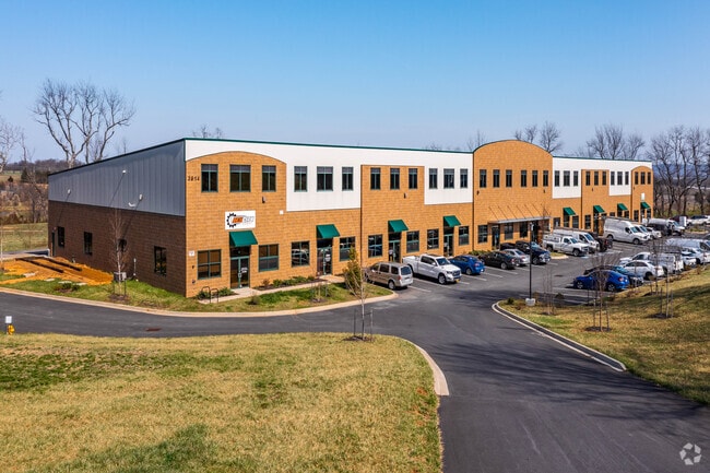
3914 Cornell Pl
01-037196
LOT 11 PLAT 4 SECTION 3-4.31 ACRES STANFORD INDUSTRIAL PARK
Industrialgeneral
Frederick
LI
Maryland
B and X Area of moderate flood hazard, usually the area between the limits of the 100-year and 500-year floods.
11
2024
4.31 AC
2025
Frederick County
752303
Washington, DC
31,475 SF
Washington-Arlington-Alexandria, DC-VA-MD-WV
NEARBY LISTINGS FOR SALE OR LEASE
DEMOGRAPHICS near 3914 Cornell Pl
1 mile
3 mile
5 mile
2025 Total Population
395
7,587
39,369
2030 Population
418
8,146
42,534
Pop Growth 2025-2030
+ 5.82%
+ 7.37%
+ 8.04%
Average Age
44
42
39
2025 Total Households
146
2,731
14,471
HH Growth 2025-2030
+ 6.16%
+ 7.51%
+ 8.20%
Median Household Inc
$155,645
$138,745
$120,471
Avg Household Size
2.70
2.70
2.70
2025 Avg HH Vehicles
3.00
3.00
2.00
Median Home Value
$594,937
$543,572
$450,141
Median Year Built
1982
1991
1995
Nearby Places
Map Layers
Map Styles
 Street
 Aerial
Layers
 Traffic
 Biking
Places
Listings with unknown addresses are not visible on the map
- Restaurants
- Banks
- Shops
- Fitness
- Groceries
PUBLIC TRANSPORTATION
COMMUTER RAIL
Point Of Rocks Marc Eb (BRUNSWICK - WASHINGTON - Maryland Transit Administration)
Drive
Walk
Distance
Point Of Rocks Marc Eb (BRUNSWICK - WASHINGTON - Maryland Transit Administration)
12 min
6.2 mi
AIRPORT
Washington Dulles International
Drive
Walk
Distance
Washington Dulles International
58 min
35.4 mi
Hagerstown Regional/Richard A Henson Field
Drive
Walk
Distance
Hagerstown Regional/Richard A Henson Field
51 min
37.3 mi
Freight Ports
Port of Baltimore
Drive
Walk
Distance
Port of Baltimore
72 min
57.3 mi
SALE & LEASE HISTORY
LISTING DATE
SALE/LEASE

Sep 03, 2024
For Lease
Jun 11, 2018
For Lease
Nearby Properties
Address
Land Use
TOTAL SIZE
Lot Size
Zoning
Address
Land Use
TOTAL SIZE
Lot Size
Zoning
3,478 SF
571.39 AC
GI
Address
Land Use
TOTAL SIZE
Lot Size
Zoning
151.16 AC
GI
Address
Land Use
TOTAL SIZE
Lot Size
Zoning
108.96 AC
I
Address
Land Use
TOTAL SIZE
Lot Size
Zoning
38,428 SF
74.89 AC
GI
Address
Land Use
TOTAL SIZE
Lot Size
Zoning
2,925 SF
423.90 AC
GI
Address
Land Use
TOTAL SIZE
Lot Size
Zoning
89,904 SF
18.90 AC
IE
Address
Land Use
TOTAL SIZE
Lot Size
Zoning
35.64 AC
GI
Address
Land Use
TOTAL SIZE
Lot Size
Zoning
3,478 SF
235.16 AC
GI
Address
Land Use
TOTAL SIZE
Lot Size
Zoning
68,880 SF
6.50 AC
LI
Address
Land Use
TOTAL SIZE
Lot Size
Zoning
51,559 SF
31.71 AC
R3
Address
Land Use
TOTAL SIZE
Lot Size
Zoning
122,742 SF
5.11 AC
LI
Address
Land Use
TOTAL SIZE
Lot Size
Zoning
60,525 SF
25.16 AC
GI
Address
Land Use
TOTAL SIZE
Lot Size
Zoning
36,518 SF
38.47 AC
A
Address
Land Use
TOTAL SIZE
Lot Size
Zoning
67,344 SF
10 AC
LI
Address
Land Use
TOTAL SIZE
Lot Size
Zoning
24,563 SF
21.87 AC
A
Address
Land Use
TOTAL SIZE
Lot Size
Zoning
37,720 SF
5.80 AC
LI
Address
Land Use
TOTAL SIZE
Lot Size
Zoning
64.38 AC
GI
Address
Land Use
TOTAL SIZE
Lot Size
Zoning
39,928 SF
6.67 AC
LI
Address
Land Use
TOTAL SIZE
Lot Size
Zoning
39,600 SF
6.46 AC
LI
Address
Land Use
TOTAL SIZE
Lot Size
Zoning
28,437 SF
4.65 AC
GC
Address
Land Use
TOTAL SIZE
Lot Size
Zoning
52,400 SF
6.57 AC
LI
Address
Land Use
TOTAL SIZE
Lot Size
Zoning
50,805 SF
4.11 AC
GC
Address
Land Use
TOTAL SIZE
Lot Size
Zoning
50,795 SF
20.27 AC
LI
Address
Land Use
TOTAL SIZE
Lot Size
Zoning
35,750 SF
8.61 AC
LI
Address
Land Use
TOTAL SIZE
Lot Size
Zoning
20,000 SF
3.35 AC
LI
Address
Land Use
TOTAL SIZE
Lot Size
Zoning
29,654 SF
6.34 AC
LI
Address
Land Use
TOTAL SIZE
Lot Size
Zoning
24,000 SF
3.29 AC
GC
Address
Land Use
TOTAL SIZE
Lot Size
Zoning
33,000 SF
3.53 AC
LI
Address
Land Use
TOTAL SIZE
Lot Size
Zoning
24,694 SF
5.33 AC
VC
Address
Land Use
TOTAL SIZE
Lot Size
Zoning
10,872 SF
6.86 AC
A
The World's #1 Commercial Real Estate Marketplace
Connect with us
© 2026 CoStar Group
The information above has been obtained from sources believed reliable. While we do not doubt its accuracy we have not verified it and make no guarantee, warranty or representation about it. It is your responsibility to independently confirm its accuracy and completeness. Any projections, opinions, assumptions, or estimates used are for example only and do not represent the current or future performance of the property. The value of this transaction to you depends on tax and other factors which should be evaluated by your tax, financial, and legal advisors. You and your advisors should conduct a careful, independent investigation of the property to determine to your satisfaction the suitability of the property for your needs.