Property Record
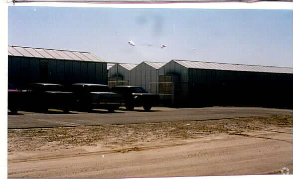
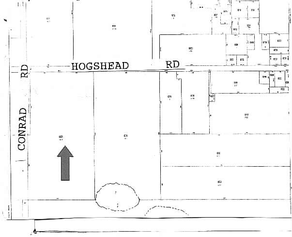
3914 Hogshead Rd, Apopka, FL 32703

Property Detail
3914 Hogshead Rd
01-2127-0000-00-067
W1/2 OF SW1/4 OF NW1/4 (LESS RD R/W ON N PER DB663/390 & W P ER DB 918/212) OF SEC 01-21-27
Horticulturegrowinghousesagricultural
ORANGE
I-L
Florida
A Areas with a 1% annual chance of flooding and a 26% chance of flooding over the life of a 30-year mortgage.
67
2025
18.55 AC
2025
NW Orange Outlying
017901
Orlando
12,320 SF
Orlando-Kissimmee-Sanford, FL
NEARBY LISTINGS FOR SALE OR LEASE
-
-
View all Apopka listings for sale on LoopNet.com
DEMOGRAPHICS near 3914 Hogshead Rd
1 mile
3 mile
5 mile
2025 Total Population
632
23,718
71,898
2030 Population
705
26,184
79,583
Pop Growth 2025-2030
+ 11.55%
+ 10.40%
+ 10.69%
Average Age
41
43
40
2025 Total Households
218
8,687
24,425
HH Growth 2025-2030
+ 11.93%
+ 10.73%
+ 11.06%
Median Household Inc
$102,155
$106,175
$97,417
Avg Household Size
2.90
2.70
2.90
2025 Avg HH Vehicles
2.00
2.00
2.00
Median Home Value
$432,520
$415,235
$420,837
Median Year Built
1997
2001
2001
Nearby Places
Map Layers
Map Styles
 Street
 Aerial
Transit
 Traffic
 Biking
Places
Listings with unknown addresses are not visible on the map
- Restaurants
- Banks
- Shops
- Fitness
- Groceries
PUBLIC TRANSPORTATION
AIRPORT
Orlando Sanford International
Drive
Walk
Distance
Orlando Sanford International
48 min
32.6 mi
Orlando International
Drive
Walk
Distance
Orlando International
46 min
34.2 mi
Freight Ports
Port Canaveral
Drive
Walk
Distance
Port Canaveral
94 min
76.7 mi
Nearby Properties
Address
Land Use
TOTAL SIZE
Lot Size
Zoning
Address
Land Use
TOTAL SIZE
Lot Size
Zoning
1,245,060 SF
90.98 AC
PD
Address
Land Use
TOTAL SIZE
Lot Size
Zoning
1,208,378 SF
57.24 AC
PD
Address
Land Use
TOTAL SIZE
Lot Size
Zoning
722,019 SF
35.47 AC
PD
Address
Land Use
TOTAL SIZE
Lot Size
Zoning
588,076 SF
38.89 AC
PD
Address
Land Use
TOTAL SIZE
Lot Size
Zoning
299,743 SF
PD
Address
Land Use
TOTAL SIZE
Lot Size
Zoning
323,161 SF
43.61 AC
PD
Address
Land Use
TOTAL SIZE
Lot Size
Zoning
347,706 SF
40.19 AC
PD
Address
Land Use
TOTAL SIZE
Lot Size
Zoning
293,305 SF
21.60 AC
PD
Address
Land Use
TOTAL SIZE
Lot Size
Zoning
278,981 SF
51.18 AC
I-L
Address
Land Use
TOTAL SIZE
Lot Size
Zoning
589,600 SF
19.60 AC
I-L
Address
Land Use
TOTAL SIZE
Lot Size
Zoning
255,880 SF
15.73 AC
PD
Address
Land Use
TOTAL SIZE
Lot Size
Zoning
133,960 SF
17.21 AC
PD
Address
Land Use
TOTAL SIZE
Lot Size
Zoning
685,777 SF
19.32 AC
I-L
Address
Land Use
TOTAL SIZE
Lot Size
Zoning
275,446 SF
12.81 AC
I-L
Address
Land Use
TOTAL SIZE
Lot Size
Zoning
503,677 SF
27.63 AC
I-L
Address
Land Use
TOTAL SIZE
Lot Size
Zoning
75.90 AC
MU-KPI
Address
Land Use
TOTAL SIZE
Lot Size
Zoning
3,688 SF
71.90 AC
MU-KPI
Address
Land Use
TOTAL SIZE
Lot Size
Zoning
144,713 SF
9.92 AC
D-APK-I-L
Address
Land Use
TOTAL SIZE
Lot Size
Zoning
178,662 SF
17.71 AC
PUD
Address
Land Use
TOTAL SIZE
Lot Size
Zoning
361,926 SF
12.79 AC
I-L
Address
Land Use
TOTAL SIZE
Lot Size
Zoning
136,824 SF
11.66 AC
C-C
Address
Land Use
TOTAL SIZE
Lot Size
Zoning
23 AC
U-ORG-P-D
Address
Land Use
TOTAL SIZE
Lot Size
Zoning
74,762 SF
4.50 AC
I-L
Address
Land Use
TOTAL SIZE
Lot Size
Zoning
14.64 AC
AG
Address
Land Use
TOTAL SIZE
Lot Size
Zoning
92,579 SF
5.86 AC
RSTD IND-2
Address
Land Use
TOTAL SIZE
Lot Size
Zoning
121,723 SF
8.41 AC
T
Address
Land Use
TOTAL SIZE
Lot Size
Zoning
98,625 SF
4.71 AC
C-C
Address
Land Use
TOTAL SIZE
Lot Size
Zoning
12,445 SF
29.23 AC
I-L
Address
Land Use
TOTAL SIZE
Lot Size
Zoning
86,011 SF
7.94 AC
C-C
Address
Land Use
TOTAL SIZE
Lot Size
Zoning
52,695 SF
57.69 AC
I-L
The World's #1 Commercial Real Estate Marketplace
Connect with us
© 2026 CoStar Group
The information above has been obtained from sources believed reliable. While we do not doubt its accuracy we have not verified it and make no guarantee, warranty or representation about it. It is your responsibility to independently confirm its accuracy and completeness. Any projections, opinions, assumptions, or estimates used are for example only and do not represent the current or future performance of the property. The value of this transaction to you depends on tax and other factors which should be evaluated by your tax, financial, and legal advisors. You and your advisors should conduct a careful, independent investigation of the property to determine to your satisfaction the suitability of the property for your needs.